METAR & TAF 26R
26R does not publish a METAR.
Showing the nearest reporting station: KVCT (VICTORIA RGNL) · 19.8 NM away. Conditions at 26R may differ.
METAR · KVCT
Observed 11:51Z
KVCT 241151Z 09003KT 3SM BR OVC020 24/24 A3008 RMK AO2 SLP183 T02390239 10256 20239 51014
- Wind
- 090° @ 3 kt
- Visibility
- 3 SM
- Temp / Dew
- 24°C / 24°C
- Altimeter
- 30.08 inHg
- Clouds
- OVC
- Density alt
- 958 ft
- Ceiling
- 2,000 ft AGL
- Rules
- MVFR
Airport info & contacts
Manager on record, flight service, ARTCC, attendance schedule and pattern altitude — published by the FAA and refreshed every 28 days.
Location
- From city
- 3 NM NE
- VFR sectional
- HOUSTON
- ARTCC
- ZHU · HOUSTON
- NOTAM facility
- CXO (NOTAM-D)
Airport manager
- Name
- RICK MCCLURE
- Phone
- 361-652-4163
- Address
- 303 MAGNOLIA, VICTORIA TX 77901
Flight service · Hours
- FSS CXO
- MONTGOMERY COUNTY1-800-WX-BRIEF
- Attendance
- Unattended
Frequencies
Tap any row to copy the frequency to your clipboard.
Runways & pattern
Full pagePattern entry · RWY 15
LEFT TRAFFICRunway end performance
| End | TORA | TODA | ASDA | LDA | VGSI | Approach lights | Obstruction |
|---|---|---|---|---|---|---|---|
| 15 | — | — | — | — | — | — | 30', pline, 1560' from thr, 0' R of cntrln, slope 45 |
Declared distances in feet. TORA = takeoff run available, TODA = takeoff distance, ASDA = accelerate-stop, LDA = landing distance.
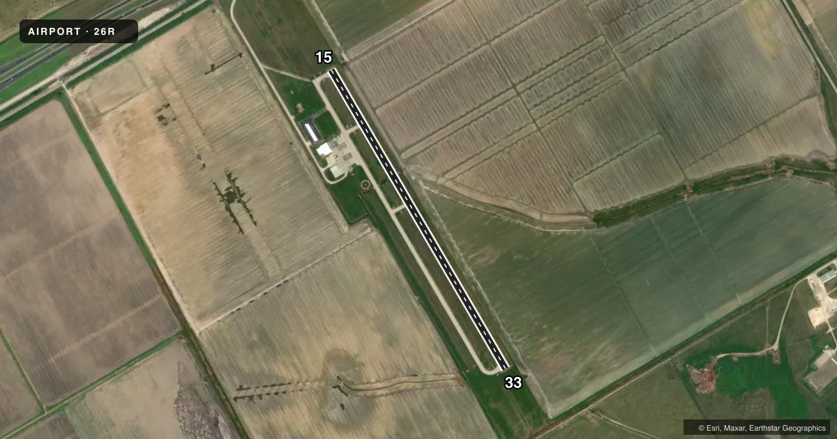
Airport sketch
Runways drawn to scale from FAA survey coordinates, rendered over satellite imagery. Not for navigation.
Approaches & charts
Services on the field
Fuel grades, oxygen, maintenance, ramp storage and lighting — as declared to the FAA by the airport operator.
Fuel & services
- Fuel
- 100LL
- Airframe repair
- Major
- Power plant repair
- Major
- Other services
- INSTR
Ramp & ground
- Transient storage
- Tie-down
- Landing fee
- No fee published
- Customs
- Not available
- Lighting schedule
- SEE RMK
- Beacon schedule
- SS-SR
- Beacon
- White / Green (civil land)(WG)
- Wind indicator
- Lighted
- Segmented circle
- Yes
Fuel & FBOs
Cheapest 100LL and Jet A on the field and nearby. Always confirm with the FBO before taxi.
Airport notes
Surface conditions, obstructions, local procedures, lighting outages and other notes published with each FAA cycle.
General notes
- TO MNT AEROBATIC BOX - 123.3.
- TWY HAS REFLECTORS ON PAVEMENT.
- FOR CD CTC HOUSTON ARTCC AT 281-230-5622.
- HVY ITNRNT TFC ON WKENDS.
Lighting notes
- MIRL RWY 15/33 PRESET TO LOW. TO INCR INTST AND ACTVT - CTAF.
Fuel notes
- 100LLFUEL 24 HRS, SELF-SERVE.
VFR map & nearby airports
VFR sectional. Tap any ICAO chip to open that airport.
Key facts · 26R
Answer card- ICAO
- 26R
- Name
- JACKSON COUNTY
- Location
- EDNA, TEXAS
- Elevation
- 61.5 ft MSL
- Traffic pattern altitude
- 1,061.5 ft MSL (1,000 AGL)
- Control tower
- Non-towered (use CTAF)
- Total runways
- 1
- Longest runway
- 15/33 · 3,393 ft
- Published ILS approaches
- 0
- Published frequencies
- 2
- Magnetic variation
- 3°
- Current flight rules
- MVFR
- Current wind
- 090° at 3 kt
- Favored runway now
- RWY 15
Jackson County Airport sits in Edna, Texas. The field elevation is 61.5 ft MSL. It has one runway, 15/33, which is 3,393 ft long and paved with asphalt. There is no control tower. CTAF and UNICOM are both 122.8. No ILS approaches are published here.
Pattern altitude is not published. Use the standard 1,000 ft AGL pattern unless the current Chart Supplement says otherwise. That works out to about 1,062 ft MSL based on the listed field elevation. The runway lighting on 15/33 is medium intensity. It starts at low setting. Use CTAF to increase intensity and activate it.
Jackson County Airport has one on-field FBO, Jackson County Airport. It carries AVGAS 100LL. Fuel is available 24 hours through self-service. Heavy itinerant traffic occurs on weekends. Plan for a busier ramp and more pattern work than you might expect. The taxiway has reflectors on the pavement. For clearance delivery, Houston Air Route Traffic Control Center is listed in the remarks. There is also an aerobatic box monitor frequency of 123.3. If you are planning a night arrival or a first visit, verify current lighting, traffic and any local procedures with the airport operator or the FBO directly by phone before departure.