METAR & TAF TX0
TX0 does not publish a METAR.
Showing the nearest reporting station: KPSX (PALACIOS MUNI) · 11.5 NM away. Conditions at TX0 may differ.
METAR · KPSX
Observed 17:53Z
KPSX 261753Z AUTO 19010KT 10SM CLR 32/25 A3004 RMK AO2 SLP173 60000 T03170250 10317 20294 58001 $
- Wind
- 190° @ 10 kt
- Visibility
- 10 SM
- Temp / Dew
- 32°C / 25°C
- Altimeter
- 30.04 inHg
- Clouds
- CLR
- Density alt
- 1,927 ft
- Ceiling
- Unlimited
- Rules
- VFR
Airport info & contacts
Manager on record, flight service, ARTCC, attendance schedule and pattern altitude — published by the FAA and refreshed every 28 days.
Location
- From city
- 7 NM SW
- VFR sectional
- HOUSTON
- ARTCC
- ZHU · HOUSTON
- NOTAM facility
- TX0
Airport manager
- Name
- JORDAN MOREHEAD
- Phone
- 361-408-0793
- Address
- 19584 S.H. 172, PORT LAVACA TX 77979
Flight service · Hours
- FSS FTW
- FORT WORTH1-800-WX-BRIEF
- Attendance
- Unattended
Frequencies
Tap any row to copy the frequency to your clipboard.
Runways & pattern
Full pagePattern entry · RWY 27
RIGHT TRAFFICRunway end performance
| End | TORA | TODA | ASDA | LDA | VGSI | Approach lights | Obstruction |
|---|---|---|---|---|---|---|---|
| 09 | — | — | — | — | PAPI 2-box left(3°) | — | 28', tree, 600' from thr, 0' R of cntrln, slope 14 |
| 27 | — | — | — | — | PAPI 2-box left(3°) | — | 18', tree, 560' from thr, 50' R of cntrln, slope 20 |
Declared distances in feet. TORA = takeoff run available, TODA = takeoff distance, ASDA = accelerate-stop, LDA = landing distance.
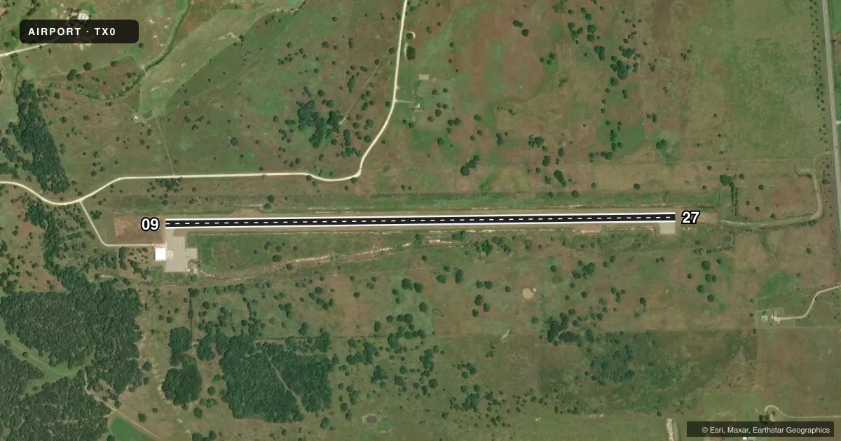
Airport sketch
Runways drawn to scale from FAA survey coordinates, rendered over satellite imagery. Not for navigation.
Approaches & charts
Services on the field
Fuel grades, oxygen, maintenance, ramp storage and lighting — as declared to the FAA by the airport operator.
Fuel & services
- Fuel
- Not available
Ramp & ground
- Transient storage
- Not published
- Lighting schedule
- SEE RMK
- Wind indicator
- Yes
Fuel & FBOs
Cheapest 100LL and Jet A on the field and nearby. Always confirm with the FBO before taxi.
Airport notes
Surface conditions, obstructions, local procedures, lighting outages and other notes published with each FAA cycle.
General notes
- FOR CD CTC HOUSTON ARTCC AT 281-230-5622.
- ARPT FENCED. GATES LOCKED. FOR ACCESS CTC AMGR.
- ARPT PHYSICAL ADDR. 19584 S.H. 172, PORT LAVACA, TX.
Lighting notes
- ACTVT REIL RWY 09 & 27; PAPI RWY 09 & 27; MIRL RWY 09/27 - CTAF.
VFR map & nearby airports
VFR sectional. Tap any ICAO chip to open that airport.
Key facts · TX0
Answer card- ICAO
- TX0
- Name
- SHANK N BANK
- Location
- LA WARD, TEXAS
- Elevation
- 29 ft MSL
- Traffic pattern altitude
- 1,029 ft MSL (1,000 AGL)
- Control tower
- Non-towered (use CTAF)
- Total runways
- 1
- Longest runway
- 09/27 · 5,002 ft
- Published ILS approaches
- 0
- Published frequencies
- 2
- Magnetic variation
- 3°
- Current flight rules
- VFR
- Current wind
- 190° at 10 kt
- Favored runway now
- RWY 27
SHANK N BANK (TX0) is in La Ward, Texas. The field elevation is 29 ft MSL. It has one runway. Runway 09/27 is 5,002 ft of asphalt. There is no control tower. CTAF and UNICOM are both 122.8. No ILS approaches are published here.
The pattern altitude is not published. For light piston traffic, use the standard 1,000 ft AGL unless the current Chart Supplement or local procedures say otherwise. The airport sits in a low coastal area. That means you should pay attention to wind and density altitude on warm days, even though the field elevation is low.
Published remarks say the airport is fenced and the gates are locked. Plan on contacting the airport manager for access. Runway end identifier lights are available on 09 and 27. PAPI is also available on both ends. Medium intensity runway lights are on 09/27 and are controlled by CTAF. There are no on-field FBOs listed, so verify fuel and services with the airport operator or call the field directly before arrival. For clearance delivery, Houston ARTCC can be reached at 281-230-5622.