METAR & TAF KPKV
Current METAR
Observed 06:15Z
KPKV 270615Z AUTO 17005KT 10SM CLR 26/26 A2997 RMK AO2 T02570257
- Wind
- 170° @ 5 kt
- Visibility
- 10 SM
- Temp / Dew
- 26°C / 26°C
- Altimeter
- 29.97 inHg
- Clouds
- CLR
- Density alt
- 1,298 ft
- Ceiling
- Unlimited
- Rules
- VFR
Airport info & contacts
Manager on record, flight service, ARTCC, attendance schedule and pattern altitude — published by the FAA and refreshed every 28 days.
Location
- From city
- 3 NM NW
- VFR sectional
- HOUSTON
- ARTCC
- ZHU · HOUSTON
- NOTAM facility
- PKV (NOTAM-D)
Airport manager
- Name
- LUDVIK SVETLIK
- Phone
- 361-552-1228
- Address
- 4876 FM 3084, PORT LAVACA TX 77979
Flight service · Hours
- FSS CXO
- MONTGOMERY COUNTY1-800-WX-BRIEF
- Attendance
- 0800-1700
Frequencies
Tap any row to copy the frequency to your clipboard.
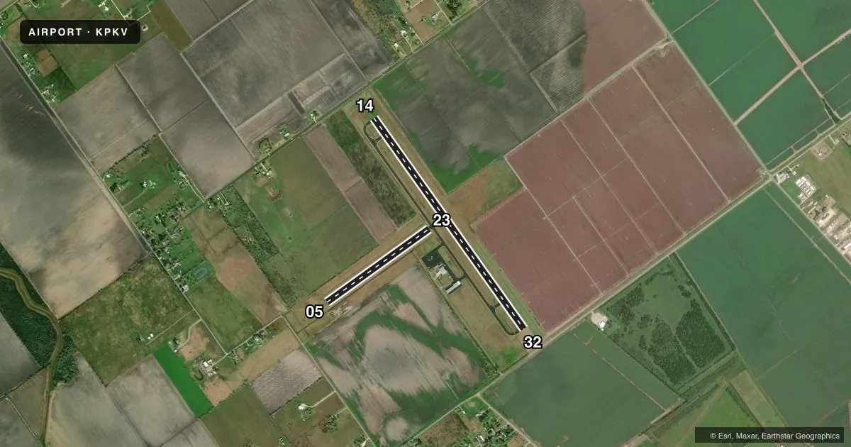
Runways & pattern
Full pagePattern entry · RWY 14
LEFT TRAFFIC| Runway | Heading (°M) | Length | Surface | Traffic |
|---|---|---|---|---|
| 14/32Favored | 139° / 319° | 5,004 ft | ASPH | 32 R |
| 05/23 | 49° / 229° | 2,432 ft | TURF | Standard L |
Runway end performance
| End | TORA | TODA | ASDA | LDA | VGSI | Approach lights | Obstruction |
|---|---|---|---|---|---|---|---|
| 14 | — | — | — | — | PAPI 2-box left(3°) | — | 13', road, 560' from thr, 290' R of cntrln, slope 27 |
| 32 | — | — | — | — | PAPI 2-box left(3°) | — | 15', road, 475' from thr, 290' R of cntrln, slope 18 |
| 05 | — | — | — | — | — | — | 22', tree, 141' from thr, 70' R of cntrln, slope 6 |
Declared distances in feet. TORA = takeoff run available, TODA = takeoff distance, ASDA = accelerate-stop, LDA = landing distance.
Airport sketch
Runways drawn to scale from FAA survey coordinates, rendered over satellite imagery. Not for navigation.
Approaches & charts
Services on the field
Fuel grades, oxygen, maintenance, ramp storage and lighting — as declared to the FAA by the airport operator.
Fuel & services
- Fuel
- 100LLA++
- Oxygen (bottled)
- Not available
- Oxygen (bulk)
- HIGH/LOW
- Airframe repair
- Major
- Power plant repair
- Major
Ramp & ground
- Transient storage
- Tie-down
- Hangar
- Landing fee
- No fee published
- Customs
- Not available
- Lighting schedule
- SEE RMK
- Beacon schedule
- SS-SR
- Beacon
- White / Green (civil land)(WG)
- Wind indicator
- Lighted
- Segmented circle
- Yes
Fuel & FBOs
Cheapest 100LL and Jet A on the field and nearby. Always confirm with the FBO before taxi.
Airport notes
Surface conditions, obstructions, local procedures, lighting outages and other notes published with each FAA cycle.
General notes
- FOR CD CTC HOUSTON ARTCC AT 281-230-5622.
- RC MODEL ACFT OPR AT RWY 5 END.
Lighting notes
- ACTVT MIRL RWY 14/32 - CTAF.
Fuel notes
- 100LL100LL AND JET A AVBL 24 HRS SELF SERVE. JET ALSO AVBL BY TRUCK.
Approach & departure obstructions
- 1422 FT TREES, 0-60 FT DSTC, 290 FT L.
- 3222 FT TREES, 0-60==135 FT DSTC, 260 FT L.
Other notes
- THIS AIRPORT HAS BEEN SURVEYED BY THE NATIONAL GEODETIC SURVEY.
VFR map & nearby airports
VFR sectional. Tap any ICAO chip to open that airport.
Key facts · KPKV
Answer card- ICAO
- KPKV
- Name
- CALHOUN COUNTY
- Location
- PORT LAVACA, TEXAS
- Elevation
- 32 ft MSL
- Traffic pattern altitude
- 1,032 ft MSL (1,000 AGL)
- Control tower
- Non-towered (use CTAF)
- Total runways
- 2
- Longest runway
- 14/32 · 5,004 ft
- Published ILS approaches
- 0
- Published frequencies
- 2
- Magnetic variation
- 5°
- Current flight rules
- VFR
- Current wind
- 170° at 5 kt
- Favored runway now
- RWY 14
Calhoun County Airport sits near Port Lavaca, Texas. Field elevation is 32 ft MSL. The airport has two runways. The longest is runway 14/32 at 5,004 ft. Runway 05/23 is turf and measures 2,432 ft.
There is no control tower. CTAF and UNICOM are both 122.8. No ILS approaches are published. Pattern altitude is not published. Use the standard 1,000 ft AGL pattern unless the current Chart Supplement says otherwise. That puts the light piston pattern near 1,032 ft MSL based on the field elevation.
Gateway Flight Center is on the field. It carries 100LL and Jet A Prist. Published remarks say 100LL and Jet A are available 24 hours self-serve. Jet fuel is also available by truck. Runway 14/32 has medium intensity lighting that is activated by CTAF. Radio-controlled model aircraft operate near the runway 5 end, so watch that area closely on arrival and departure. For clearance delivery, contact Houston ARTCC at the published number before departure if you need it. This is a low-elevation coastal field, so density altitude is usually less of a concern than wind and runway selection. Check the current Chart Supplement for any noise or local operating notes before you go.