METAR & TAF KRFG
KRFG does not publish a METAR.
Showing the nearest reporting station: KRKP (ARANSAS COUNTY) · 19.5 NM away. Conditions at KRFG may differ.
METAR · KRKP
Observed 18:53Z
KRKP 261853Z AUTO 16009KT 9SM CLR 33/24 A3002 RMK AO2 SLP166 T03280239
- Wind
- 160° @ 9 kt
- Visibility
- 9 SM
- Temp / Dew
- 33°C / 24°C
- Altimeter
- 30.02 inHg
- Clouds
- CLR
- Density alt
- 2,103 ft
- Ceiling
- Unlimited
- Rules
- VFR
Airport info & contacts
Manager on record, flight service, ARTCC, attendance schedule and pattern altitude — published by the FAA and refreshed every 28 days.
Location
- From city
- 3 NM W
- VFR sectional
- SAN ANTONIO
- Pattern altitude
- 800 ft AGL · 854 ft MSL
- ARTCC
- ZHU · HOUSTON
- NOTAM facility
- SJT (NOTAM-D)
Airport manager
- Name
- JOSEPH GONZALES
- Phone
- 252-665-3509
- Address
- 808 COMMERCE ST.WOODSBORO TX 78393
Flight service · Hours
- FSS SJT
- SAN ANGELO1-800-WX-BRIEF
- Attendance
- 0800-2000
Frequencies
Tap any row to copy the frequency to your clipboard.
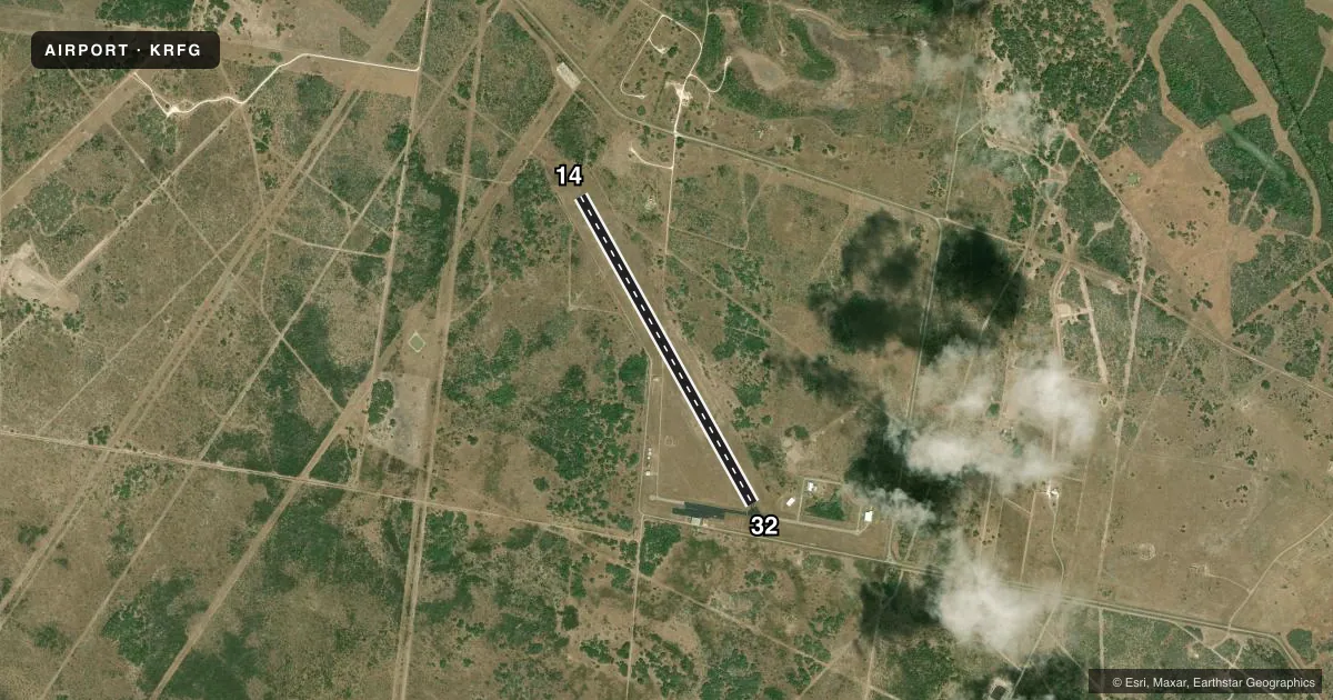
Runways & pattern
Full pagePattern entry · RWY 14
LEFT TRAFFICRunway end performance
| End | TORA | TODA | ASDA | LDA | VGSI | Approach lights | Obstruction |
|---|---|---|---|---|---|---|---|
| 14 | — | — | — | — | PAPI 2-box left(3°) | — | — |
Declared distances in feet. TORA = takeoff run available, TODA = takeoff distance, ASDA = accelerate-stop, LDA = landing distance.
Airport sketch
Runways drawn to scale from FAA survey coordinates, rendered over satellite imagery. Not for navigation.
Approaches & charts
Services on the field
Fuel grades, oxygen, maintenance, ramp storage and lighting — as declared to the FAA by the airport operator.
Fuel & services
- Fuel
- 100LL
- Oxygen (bottled)
- Not available
- Oxygen (bulk)
- Not available
- Airframe repair
- Not available
- Power plant repair
- Not available
- Other services
- GLD
Ramp & ground
- Transient storage
- Tie-down
- Landing fee
- No fee published
- Customs
- Not available
- Lighting schedule
- SEE RMK
- Beacon schedule
- SS-SR
- Beacon
- White / Green (civil land)(WG)
- Wind indicator
- Yes
- Segmented circle
- Yes
Fuel & FBOs
Cheapest 100LL and Jet A on the field and nearby. Always confirm with the FBO before taxi.
Airport notes
Surface conditions, obstructions, local procedures, lighting outages and other notes published with each FAA cycle.
General notes
- GLIDER ACTVTY ON & INVOF ARPT.
- WILDLIFE ON & INVOF ARPT.
- FOR CD CTC HOUSTON ARTCC AT 281-230-5622.
Lighting notes
- MIRL RWY 14/32 SS-SR PRESET LOW. TO INCR INTST - CTAF.
Fuel notes
- 100LLFUEL AVBL 24 HRS SELF SVC.
Runway surface & condition
- 14/32NO LINE OF SIGHT LTD BTN RWY ENDS.
Approach & departure obstructions
- 32APCH SLOPE 36:1 FM DSPLCD THR OVR 15 FT ROAD 541 FT DSTC; 22:1 OVR 40 FT TWR, 882 FT DSTC, 125 FT R.
Other notes
- PREDATES ACT.
VFR map & nearby airports
VFR sectional. Tap any ICAO chip to open that airport.
Key facts · KRFG
Answer card- ICAO
- KRFG
- Name
- ROOKE FLD
- Location
- REFUGIO, TEXAS
- Elevation
- 54 ft MSL
- Traffic pattern altitude
- 854 ft MSL (800 AGL)
- Control tower
- Non-towered (use CTAF)
- Total runways
- 1
- Longest runway
- 14/32 · 4,361 ft
- Published ILS approaches
- 0
- Published frequencies
- 2
- Magnetic variation
- 7°
- Current flight rules
- VFR
- Current wind
- 160° at 9 kt
- Favored runway now
- RWY 14
Rooke Fld sits in Refugio, Texas. Field elevation is 54 ft MSL. The airport has one runway. Runway 14/32 is 4,361 ft of asphalt, which is the longest runway on the field. There is no control tower. CTAF and UNICOM are both 122.8. No ILS approaches are published here. Pattern altitude is 800 ft AGL, which is 854 ft MSL.
Refugio County Airport is the on-field FBO. It carries 100LL. Fuel is available 24 hours self service for 100LL. Published remarks also note faded runway markings on both ends. Runway 14/32 has medium intensity lights preset low from sunset to sunrise. Use CTAF to increase intensity. Runway 14 PAPI operates continuously.
A first-time pilot should plan for wildlife and glider activity in the area. Runway line of sight is limited between the ends. Runway 32 has a published obstacle note on approach, so verify the current Chart Supplement before arrival and brief the approach carefully. For clearance delivery contact Houston ARTCC at 281-230-5622. This is an uncontrolled field, so standard self-announce discipline matters on the CTAF.