METAR & TAF KRAS
Current METAR
Observed 06:35Z
KRAS 270635Z AUTO 16011KT 10SM CLR 28/25 A3000 RMK AO2 T02820249
- Wind
- 160° @ 11 kt
- Visibility
- 10 SM
- Temp / Dew
- 28°C / 25°C
- Altimeter
- 30.00 inHg
- Clouds
- CLR
- Density alt
- 1,467 ft
- Ceiling
- Unlimited
- Rules
- VFR
Airport info & contacts
Manager on record, flight service, ARTCC, attendance schedule and pattern altitude — published by the FAA and refreshed every 28 days.
Location
- From city
- 2 NM SW
- VFR sectional
- BROWNSVILLE
- ARTCC
- ZHU · HOUSTON
- NOTAM facility
- RAS (NOTAM-D)
Airport manager
- Name
- CHRIS SHANKLIN
- Phone
- 361-749-4008
- Address
- 710 W. AVE A, PORT ARANSAS TX 78373-4128
Flight service · Hours
- FSS SJT
- SAN ANGELO1-800-WX-BRIEF
- Attendance
- IREG
Frequencies
Tap any row to copy the frequency to your clipboard.
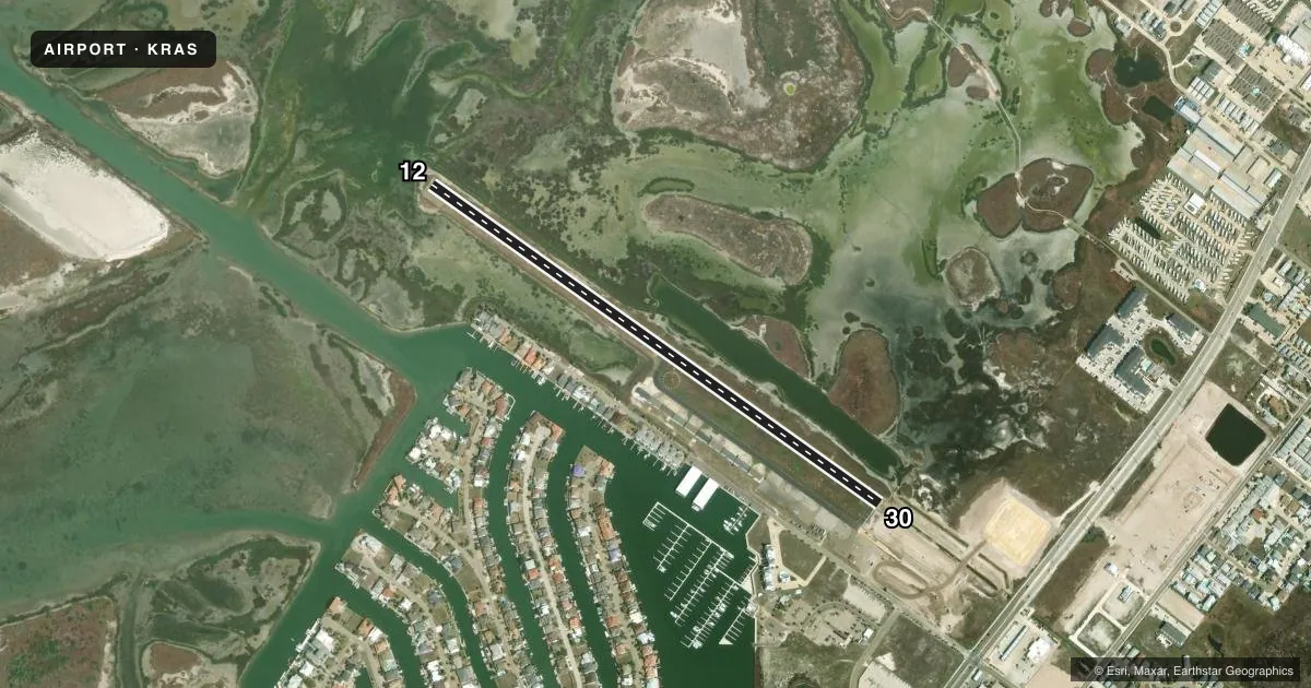
Runways & pattern
Full pagePattern entry · RWY 12
LEFT TRAFFICRunway end performance
| End | TORA | TODA | ASDA | LDA | VGSI | Approach lights | Obstruction |
|---|---|---|---|---|---|---|---|
| 12 | — | — | — | — | PAPI 2-box left(3°) | — | — |
| 30 | — | — | — | — | PAPI 2-box left(3.2°) | — | 38', pline, 465' from thr, 325' R of cntrln, slope 6 |
Declared distances in feet. TORA = takeoff run available, TODA = takeoff distance, ASDA = accelerate-stop, LDA = landing distance.
Airport sketch
Runways drawn to scale from FAA survey coordinates, rendered over satellite imagery. Not for navigation.
Approaches & charts
Services on the field
Fuel grades, oxygen, maintenance, ramp storage and lighting — as declared to the FAA by the airport operator.
Fuel & services
- Fuel
- 100LL
- Other services
- PAJA
Ramp & ground
- Transient storage
- Tie-down
- Landing fee
- No fee published
- Lighting schedule
- SS-SR
- Beacon schedule
- SS-SR
- Beacon
- White / Green (civil land)(WG)
- Wind indicator
- Lighted
- Segmented circle
- Yes
Fuel & FBOs
Cheapest 100LL and Jet A on the field and nearby. Always confirm with the FBO before taxi.
Airport notes
Surface conditions, obstructions, local procedures, lighting outages and other notes published with each FAA cycle.
General notes
- RWY 12, 3 FT DROP OFF 40 FM RWY END.
- RWY 30, 36 FT PLINE 1135 FT DSTC. 50 FT PLINE 1770 FT DSTC.
- FOR CD CTC CORPUS CHRISTI APCH AT 361-299-4230.
Fuel notes
- 100LLFUEL 24 HR SELF SERV.
Approach & departure obstructions
- 12OBSTN CLNC SLOPE 30:1 TO DSPLCD THR.
Other notes
- MAY BE EXEMPT UNDER GRANDFATHER CLAUSE.
VFR map & nearby airports
VFR sectional. Tap any ICAO chip to open that airport.
Key facts · KRAS
Answer card- ICAO
- KRAS
- Name
- MUSTANG BEACH
- Location
- PORT ARANSAS, TEXAS
- Elevation
- 5 ft MSL
- Traffic pattern altitude
- 1,005 ft MSL (1,000 AGL)
- Control tower
- Non-towered (use CTAF)
- Total runways
- 1
- Longest runway
- 12/30 · 3,482 ft
- Published ILS approaches
- 0
- Published frequencies
- 3
- Magnetic variation
- 5°
- Current flight rules
- VFR
- Current wind
- 160° at 11 kt
- Favored runway now
- RWY 12
Mustang Beach Airport sits in Port Aransas, Texas. Field elevation is 5 ft MSL. The airport has one runway. Runway 12/30 is 3,482 ft long with an asphalt surface. There is no control tower. No ILS approaches are published here.
Pattern altitude is not published. Use 1,000 ft AGL for light piston ops unless the current Chart Supplement says otherwise. The field is served by Mustang Beach Airport on the field. It carries 100LL. Fuel is available 24 hours self-service. For clearance delivery, Corpus Christi Approach is listed in the remarks.
A few runway notes matter here. Runway 12 has a 30 to 1 obstacle clearance slope to the displaced threshold. There is also a 3 ft drop off 40 ft from the runway end. Runway 30 has power lines 1,135 ft and 1,770 ft from the threshold. Pilots should brief the departure and arrival path carefully. Check the current Chart Supplement for any published noise or curfew restrictions before flying into the field. If you need current operational details, call the airport operator or the FBO directly by phone.