METAR & TAF KRBO
Current METAR
Observed 08:35Z
KRBO 270835Z AUTO 18003KT A2997 RMK AO2 PWINO
- Wind
- 180° @ 3 kt
- Visibility
- —
- Temp / Dew
- —
- Altimeter
- 29.97 inHg
- Clouds
- Clear
- Density alt
- —
- Ceiling
- Unlimited
- Rules
- VFR
Airport info & contacts
Manager on record, flight service, ARTCC, attendance schedule and pattern altitude — published by the FAA and refreshed every 28 days.
Location
- From city
- 2 NM SW
- VFR sectional
- BROWNSVILLE
- ARTCC
- ZHU · HOUSTON
- NOTAM facility
- RBO (NOTAM-D)
Airport manager
- Name
- BENJAMIN GARCIA
- Phone
- 361-387-1700
- Address
- 3983 WINGS DR., ROBSTOWN TX 78380
Flight service · Hours
- FSS SJT
- SAN ANGELO1-800-WX-BRIEF
- Attendance
- MON-FRI · 0800-1700
Frequencies
Tap any row to copy the frequency to your clipboard.
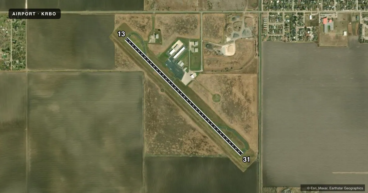
Runways & pattern
Full pagePattern entry · RWY 13
LEFT TRAFFICRunway end performance
| End | TORA | TODA | ASDA | LDA | VGSI | Approach lights | Obstruction |
|---|---|---|---|---|---|---|---|
| 13 | — | — | — | — | — | — | 15', road, 528' from thr, 312' R of cntrln, slope 21 |
| 31 | — | — | — | — | — | — | 20', trees, 1030' from thr, 0' R of cntrln, slope 41 |
Declared distances in feet. TORA = takeoff run available, TODA = takeoff distance, ASDA = accelerate-stop, LDA = landing distance.
Airport sketch
Runways drawn to scale from FAA survey coordinates, rendered over satellite imagery. Not for navigation.
Approaches & charts
Services on the field
Fuel grades, oxygen, maintenance, ramp storage and lighting — as declared to the FAA by the airport operator.
Fuel & services
- Fuel
- 100LLA+
- Oxygen (bottled)
- Not available
- Oxygen (bulk)
- Not available
- Airframe repair
- Minor
- Power plant repair
- Minor
Ramp & ground
- Transient storage
- Tie-down
- Landing fee
- No fee published
- Customs
- Not available
- Lighting schedule
- SEE RMK
- Beacon schedule
- SS-SR
- Beacon
- White / Green (civil land)(WG)
- Wind indicator
- Lighted
- Segmented circle
- Yes
Fuel & FBOs
Cheapest 100LL and Jet A on the field and nearby. Always confirm with the FBO before taxi.
Airport notes
Surface conditions, obstructions, local procedures, lighting outages and other notes published with each FAA cycle.
General notes
- 1049 FT MSL TWRS 3 NM EAST OF ARPT.
- FOR CD CTC CORPUS CHRISTI APCH AT 361-299-4230.
Lighting notes
- MIRL RWY 13/31 PRESET LOW INTST; TO INCR INTST ACTVT - 122.8.
Fuel notes
- 100LL100 LL & JET A AVBL 24 HRS SELF-SERVE ONLY.
VFR map & nearby airports
VFR sectional. Tap any ICAO chip to open that airport.
Key facts · KRBO
Answer card- ICAO
- KRBO
- Name
- NUECES COUNTY
- Location
- ROBSTOWN, TEXAS
- Elevation
- 79.7 ft MSL
- Traffic pattern altitude
- 1,079.7 ft MSL (1,000 AGL)
- Control tower
- Non-towered (use CTAF)
- Total runways
- 1
- Longest runway
- 13/31 · 3,700 ft
- Published ILS approaches
- 0
- Published frequencies
- 3
- Magnetic variation
- 6°
- Current flight rules
- VFR
- Current wind
- 180° at 3 kt
- Favored runway now
- RWY 13
Nueces County Airport (KRBO) sits in Robstown, Texas. Field elevation is 79.7 ft MSL. The airport has one runway. Runway 13/31 is 3,700 ft long with asphalt pavement. There is no control tower. Clearance delivery is handled through Corpus Christi Approach at 361-299-4230.
No ILS approaches are published here. The published pattern altitude is not listed, so plan on the standard 1,000 ft AGL for light piston operations unless the current FAA Chart Supplement says otherwise. The airport uses CTAF 122.9. Medium intensity runway lights on 13/31 are preset to low intensity. They can be increased by keying 122.8.
Nueces County Airport is a straightforward local field, but there are 1,049 ft MSL towers about 3 NM east of the airport. That matters on departure and in the pattern. The on-field FBO is Nueces County Airport. It carries 100LL and Jet A. Fuel is available 24 hours self-serve only. If you are planning a first stop here, verify current procedures with the airport operator or the FBO directly before arrival.