METAR & TAF KIKG
Current METAR
Observed 16:15Z
KIKG 261615Z AUTO 16007KT 140V200 10SM SCT035 32/23 A3004 RMK AO2 T03210226
- Wind
- 160° @ 7 kt
- Visibility
- 10 SM
- Temp / Dew
- 32°C / 23°C
- Altimeter
- 30.04 inHg
- Clouds
- SCT
- Density alt
- 2,053 ft
- Ceiling
- Unlimited
- Rules
- VFR
Airport info & contacts
Manager on record, flight service, ARTCC, attendance schedule and pattern altitude — published by the FAA and refreshed every 28 days.
Location
- From city
- 9 NM W
- VFR sectional
- BROWNSVILLE
- ARTCC
- ZHU · HOUSTON
- NOTAM facility
- SJT (NOTAM-D)
Airport manager
- Name
- MIKE MUZYCZYN, FBO
- Phone
- 361-592-1225
- Address
- PO BOX 53, KINGSVILLE TX 78364
Flight service · Hours
- FSS SJT
- SAN ANGELO1-800-WX-BRIEF
- Attendance
- MON-FRI · 0800-1630
- SAT-SUN · 0800-1500
Frequencies
Tap any row to copy the frequency to your clipboard.
Runways & pattern
Full pagePattern entry · RWY 13
LEFT TRAFFICRunway end performance
| End | TORA | TODA | ASDA | LDA | VGSI | Approach lights | Obstruction |
|---|---|---|---|---|---|---|---|
| 13 | — | — | — | — | PAPI 4-box left(3°) | — | 20', trees, 201' from thr, 270' R of cntrln, slope 0 |
| 31 | — | — | — | — | PAPI 4-box left(3°) | — | 30', tree, 1460' from thr, 540' R of cntrln, slope 42 |
Declared distances in feet. TORA = takeoff run available, TODA = takeoff distance, ASDA = accelerate-stop, LDA = landing distance.
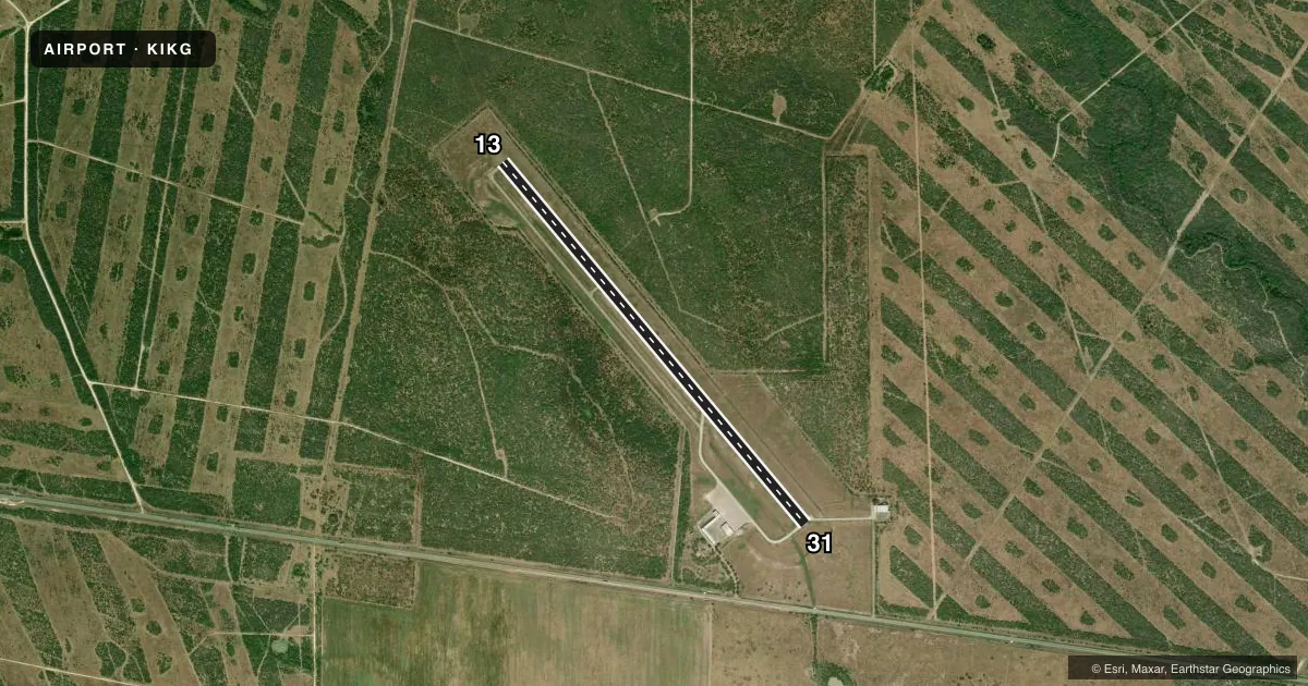
Airport sketch
Runways drawn to scale from FAA survey coordinates, rendered over satellite imagery. Not for navigation.
Approaches & charts
Services on the field
Fuel grades, oxygen, maintenance, ramp storage and lighting — as declared to the FAA by the airport operator.
Fuel & services
- Fuel
- 100LLA+
- Oxygen (bottled)
- High pressure
- Oxygen (bulk)
- Not available
- Airframe repair
- Major
- Power plant repair
- Major
Ramp & ground
- Transient storage
- Tie-down
- Hangar
- Landing fee
- Yes
- Customs
- Not available
- Lighting schedule
- SEE RMK
- Beacon schedule
- SS-SR
- Beacon
- White / Green (civil land)(WG)
- Wind indicator
- Lighted
- Segmented circle
- Yes
Fuel & FBOs
Cheapest 100LL and Jet A on the field and nearby. Always confirm with the FBO before taxi.
Airport notes
Surface conditions, obstructions, local procedures, lighting outages and other notes published with each FAA cycle.
General notes
- BIRDS ON & INVOF ARPT.
- FOR CD CTC HOUSTON ARTCC AT 281-230-5622.
Lighting notes
- SS-SR MIRL RWY 13/31 PRESET LOW INTST; TO INCR INTST & ACTVT REIL RWYS 13 & 31 - CTAF.
Approach & departure obstructions
- 1320 FT TREES 0-199 FT FM THR 270 FT L.
- 13RWY MKGS FADED.
- 31RWY MKGS FADED.
Other notes
- THIS AIRPORT HAS BEEN SURVEYED BY THE NATIONAL GEODETIC SURVEY.
- LDG FEE FOR TURBINE & JET ACFT. FEE WAIVED WITH MNM FUEL PURCHASE.
VFR map & nearby airports
VFR sectional. Tap any ICAO chip to open that airport.
Key facts · KIKG
Answer card- ICAO
- KIKG
- Name
- KLEBERG COUNTY
- Location
- KINGSVILLE, TEXAS
- Elevation
- 130.1 ft MSL
- Traffic pattern altitude
- 1,130.1 ft MSL (1,000 AGL)
- Control tower
- Non-towered (use CTAF)
- Total runways
- 1
- Longest runway
- 13/31 · 6,000 ft
- Published ILS approaches
- 0
- Published frequencies
- 5
- Magnetic variation
- 6°
- Current flight rules
- VFR
- Current wind
- 160° at 7 kt
- Favored runway now
- RWY 13
Kleberg County Airport is in Kingsville, Texas. The field elevation is 130.1 ft MSL. It has one runway. The longest runway is 6,000 ft of asphalt. There is no control tower. CTAF and UNICOM are both 122.7. No ILS approaches are published here.
Pattern altitude is not published. Use 1,000 ft AGL for light piston operations unless the current Chart Supplement says otherwise. The field has faded runway markings on both runway 13 and runway 31. At night, the medium intensity runway lights are preset to low intensity. Use CTAF to increase light intensity. Use CTAF to activate the runway end identifier lights.
Mike's Aircraft Shop is on the field. It carries 100LL and Jet A Prist. For turbine and jet aircraft, there is a landing fee unless it is waived by a minimum fuel purchase. Runway 13 also has 20 ft trees near the threshold area, so pay attention on short final. Birds are reported on and near the airport. For clearance delivery, contact Houston ARTCC. First-time pilots should plan for an uncontrolled field with a single long runway, faded markings and a few local hazards to watch on approach.