METAR & TAF KBKS
Current METAR
Observed 12:55Z
KBKS 271255Z AUTO 11004KT 8SM CLR 25/24 A2994 RMK AO2 T02460244 $
- Wind
- 110° @ 4 kt
- Visibility
- 8 SM
- Temp / Dew
- 25°C / 24°C
- Altimeter
- 29.94 inHg
- Clouds
- CLR
- Density alt
- 1,314 ft
- Ceiling
- Unlimited
- Rules
- VFR
Airport info & contacts
Manager on record, flight service, ARTCC, attendance schedule and pattern altitude — published by the FAA and refreshed every 28 days.
Location
- From city
- 2 NM SE
- VFR sectional
- BROWNSVILLE
- ARTCC
- ZHU · HOUSTON
- NOTAM facility
- BKS (NOTAM-D)
Airport manager
- Name
- BOND COSBY
- Phone
- 361-325-2909
- Address
- PO BOX 556, FALFURRIAS TX 78355
Flight service · Hours
- FSS SJT
- SAN ANGELO1-800-WX-BRIEF
- Attendance
- NOV-FEB · 0900-1700
- MAR-OCT · MON-FRI · 0900-1600
Frequencies
Tap any row to copy the frequency to your clipboard.
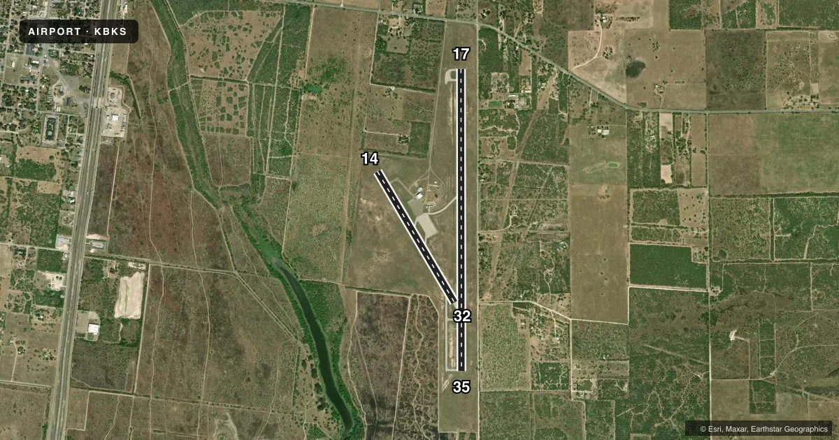
Runways & pattern
Full pagePattern entry · RWY 14
LEFT TRAFFIC| Runway | Heading (°M) | Length | Surface | Traffic |
|---|---|---|---|---|
| 17/35 | 174° / 354° | 6,006 ft | ASPH | Standard L |
| 14/32Favored | 143° / 323° | 3,018 ft | ASPH | Standard L |
Runway end performance
| End | TORA | TODA | ASDA | LDA | VGSI | Approach lights | Obstruction |
|---|---|---|---|---|---|---|---|
| 17 | — | — | — | — | PAPI 4-box left(3°) | — | 36', tree, 1046' from thr, 415' R of cntrln, slope 23 |
| 35 | — | — | — | — | PAPI 4-box left(3°) | — | — |
| 14 | — | — | — | — | — | — | 25', trees, 450' from thr, 100' R of cntrln, slope 10 |
Declared distances in feet. TORA = takeoff run available, TODA = takeoff distance, ASDA = accelerate-stop, LDA = landing distance.
Airport sketch
Runways drawn to scale from FAA survey coordinates, rendered over satellite imagery. Not for navigation.
Approaches & charts
Services on the field
Fuel grades, oxygen, maintenance, ramp storage and lighting — as declared to the FAA by the airport operator.
Fuel & services
- Fuel
- 100LLA
- Oxygen (bottled)
- Not available
- Oxygen (bulk)
- Not available
- Airframe repair
- Not available
- Power plant repair
- Not available
Ramp & ground
- Transient storage
- Tie-down
- Landing fee
- No fee published
- Customs
- Not available
- Lighting schedule
- SEE RMK
- Beacon schedule
- SS-SR
- Beacon
- White / Green (civil land)(WG)
- Wind indicator
- Lighted
- Segmented circle
- Yes
Fuel & FBOs
Cheapest 100LL and Jet A on the field and nearby. Always confirm with the FBO before taxi.
Airport notes
Surface conditions, obstructions, local procedures, lighting outages and other notes published with each FAA cycle.
General notes
- 9 FT FENCE LCTD APRX 900 FT NORTH OF RWY 17.
- FOR CD CTC HOUSTON ARTCC AT 281-230-5622.
Lighting notes
- MIRL RWY 17/35 PRESET LOW INTST. TO INCR INTST & ACTVT REIL RWY 17; PAPI RWYS 17 & 35 - CTAF.
Other notes
- 2FOR ATTENDANT AFT HRS CALL 361-325-2909.
- MANAGER361-850-3430 OR FROM NOV-FEB ON CALL 24/7
VFR map & nearby airports
VFR sectional. Tap any ICAO chip to open that airport.
Key facts · KBKS
Answer card- ICAO
- KBKS
- Name
- BROOKS COUNTY
- Location
- FALFURRIAS, TEXAS
- Elevation
- 111.7 ft MSL
- Traffic pattern altitude
- 1,111.7 ft MSL (1,000 AGL)
- Control tower
- Non-towered (use CTAF)
- Total runways
- 2
- Longest runway
- 17/35 · 6,006 ft
- Published ILS approaches
- 0
- Published frequencies
- 5
- Magnetic variation
- 6°
- Current flight rules
- VFR
- Current wind
- 110° at 4 kt
- Favored runway now
- RWY 14
Brooks County Airport sits in Falfurrias, Texas. Field elevation is 111.7 ft MSL. The airport has 2 asphalt runways. The longest is runway 17/35 at 6,006 ft. There is no control tower, so plan to self-announce on CTAF 122.8 and work the pattern with local traffic in mind.
No ILS approaches are published here. Pattern altitude is not published, so use the standard 1,000 ft AGL for light piston operations unless the current Chart Supplement says otherwise. CosbyAir is on the field. It carries 100LL, Jet A and Jet A Prist. The published remarks also note that runway 17/35 lighting is preset to low intensity. Use CTAF to raise the lights and activate the runway end identifier lights on runway 17. PAPI is installed on runways 17 and 35. It is also activated via CTAF.
For a first-time arrival, pay attention to the runway layout and the fence north of runway 17. The field is in south Texas, so density altitude can matter on warm days even at this low elevation. Clearance delivery is handled through Houston ARTCC if you need it. If you are arriving after hours, verify current service with the FBO directly by phone.