METAR & TAF KHBV
Current METAR
Observed 06:15Z
KHBV 270615Z AUTO 15008KT 10SM CLR 27/23 A2997 RMK AO2 T02670230 $
- Wind
- 150° @ 8 kt
- Visibility
- 10 SM
- Temp / Dew
- 27°C / 23°C
- Altimeter
- 29.97 inHg
- Clouds
- CLR
- Density alt
- 2,200 ft
- Ceiling
- Unlimited
- Rules
- VFR
Airport info & contacts
Manager on record, flight service, ARTCC, attendance schedule and pattern altitude — published by the FAA and refreshed every 28 days.
Location
- From city
- 3 NM NW
- VFR sectional
- BROWNSVILLE
- ARTCC
- ZHU · HOUSTON
- NOTAM facility
- HBV (NOTAM-D)
Airport manager
- Name
- CLARK ROSSI
- Phone
- 956-693-7751
- Address
- PO BOX 24, HEBBRONVILLE TX 78361
Flight service · Hours
- FSS SJT
- SAN ANGELO1-800-WX-BRIEF
- Attendance
- Unattended
Frequencies
Tap any row to copy the frequency to your clipboard.
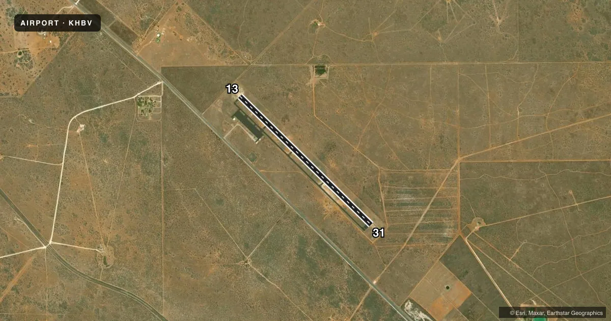
Runways & pattern
Full pagePattern entry · RWY 13
LEFT TRAFFICRunway end performance
| End | TORA | TODA | ASDA | LDA | VGSI | Approach lights | Obstruction |
|---|---|---|---|---|---|---|---|
| 13 | — | — | — | — | PAPI 2-box left(3°) | — | 15', trees, 415' from thr, 34' R of cntrln, slope 14 |
| 31 | — | — | — | — | PAPI 2-box left(3°) | — | 12', tree, 433' from thr, 200' R of cntrln, slope 19 |
Declared distances in feet. TORA = takeoff run available, TODA = takeoff distance, ASDA = accelerate-stop, LDA = landing distance.
Airport sketch
Runways drawn to scale from FAA survey coordinates, rendered over satellite imagery. Not for navigation.
Approaches & charts
Services on the field
Fuel grades, oxygen, maintenance, ramp storage and lighting — as declared to the FAA by the airport operator.
Fuel & services
- Fuel
- A
- Airframe repair
- Not available
- Power plant repair
- Not available
Ramp & ground
- Transient storage
- Tie-down
- Landing fee
- No fee published
- Customs
- Not available
- Lighting schedule
- SEE RMK
- Beacon schedule
- SS-SR
- Beacon
- White / Green (civil land)(WG)
- Wind indicator
- Lighted
- Segmented circle
- Yes
Fuel & FBOs
Cheapest 100LL and Jet A on the field and nearby. Always confirm with the FBO before taxi.
Airport notes
Surface conditions, obstructions, local procedures, lighting outages and other notes published with each FAA cycle.
General notes
- LRG ACFT EXITING RWY 31 SHOULD BACK TAXI ON RWY DUE TO OBSTN ON TWY.
- FOR CD CTC HOUSTON ARTCC AT 281-230-5622.
- NO PUBLIC FACILITIES.
Lighting notes
- MIRL RWY 13/31 PRESET LOW INTST; TO INCR INTST ACTVT - CTAF.
Fuel notes
- AFOR JET A, CALL 361-850-3430.
Runway surface & condition
- 13/31GWT PAVEMENT STRENGTH PRVDD BY ARPT MGR.
Other notes
- THIS AIRPORT HAS BEEN SURVEYED BY THE NATIONAL GEODETIC SURVEY.
- 1ATTENDANT ON CALL.
- OWNERHUMBERTO GONZALES, COUNTY JUDGE
- MANAGEROR 361-527-4461
VFR map & nearby airports
VFR sectional. Tap any ICAO chip to open that airport.
Key facts · KHBV
Answer card- ICAO
- KHBV
- Name
- JIM HOGG COUNTY
- Location
- HEBBRONVILLE, TEXAS
- Elevation
- 662.8 ft MSL
- Traffic pattern altitude
- 1,662.8 ft MSL (1,000 AGL)
- Control tower
- Non-towered (use CTAF)
- Total runways
- 1
- Longest runway
- 13/31 · 5,003 ft
- Published ILS approaches
- 0
- Published frequencies
- 2
- Magnetic variation
- 6°
- Current flight rules
- VFR
- Current wind
- 150° at 8 kt
- Favored runway now
- RWY 13
JIM HOGG COUNTY Airport sits in Hebbronville, Texas. The field elevation is 662.8 ft MSL. It has one runway. Runway 13/31 is 5,003 ft long with asphalt pavement. The airport is non-towered. CTAF and UNICOM are both 122.8. No ILS approaches are published here.
The pattern altitude is not published in the facts. Use 1,000 ft AGL for light piston operations unless the current FAA Chart Supplement says otherwise. That puts the normal traffic pattern at about 1,663 ft MSL based on the field elevation. Check the current Chart Supplement before flight for any updates.
CosbyAir is on the field. It carries Jet A. Call ahead at (361) 850-3430 for current fuel and service status. The published remarks also note that runway 13/31 lighting is medium intensity and starts at low intensity. Pilots can increase it by keying the CTAF. The PAPI for runway 13 runs continuously. Large aircraft exiting runway 31 should plan to back taxi on the runway because of a taxiway obstruction. Clearance delivery is handled through Houston ARTCC at 281-230-5622. Expect a straightforward rural field with one runway and no published ILS support.