METAR & TAF KAPY
Current METAR
Observed 05:35Z
KAPY 270535Z AUTO 15010G16KT 10SM CLR 29/21 A2997 RMK AO2 T02940205
- Wind
- 150° @ 10G16 kt
- Visibility
- 10 SM
- Temp / Dew
- 29°C / 21°C
- Altimeter
- 29.97 inHg
- Clouds
- CLR
- Density alt
- 2,141 ft
- Ceiling
- Unlimited
- Rules
- VFR
Airport info & contacts
Manager on record, flight service, ARTCC, attendance schedule and pattern altitude — published by the FAA and refreshed every 28 days.
Location
- From city
- 4 NM NE
- VFR sectional
- BROWNSVILLE
- ARTCC
- ZHU · HOUSTON
- NOTAM facility
- SJT (NOTAM-D)
Airport manager
- Name
- DOMINGO CASTANEDA
- Phone
- 956-334-5345
- Address
- 246 AIRPORT RD, P O BOX 760, ZAPATA TX 78076
Flight service · Hours
- FSS SJT
- SAN ANGELO1-800-WX-BRIEF
- Attendance
- IREG
Frequencies
Tap any row to copy the frequency to your clipboard.
Runways & pattern
Full pagePattern entry · RWY 12
LEFT TRAFFICRunway end performance
| End | TORA | TODA | ASDA | LDA | VGSI | Approach lights | Obstruction |
|---|---|---|---|---|---|---|---|
| 12 | — | — | — | — | — | — | 18', trees, 277' from thr, 36' R of cntrln, slope 4 |
| 30 | — | — | — | — | — | — | 20', trees, 201' from thr, 125' R of cntrln, slope 0 |
Declared distances in feet. TORA = takeoff run available, TODA = takeoff distance, ASDA = accelerate-stop, LDA = landing distance.
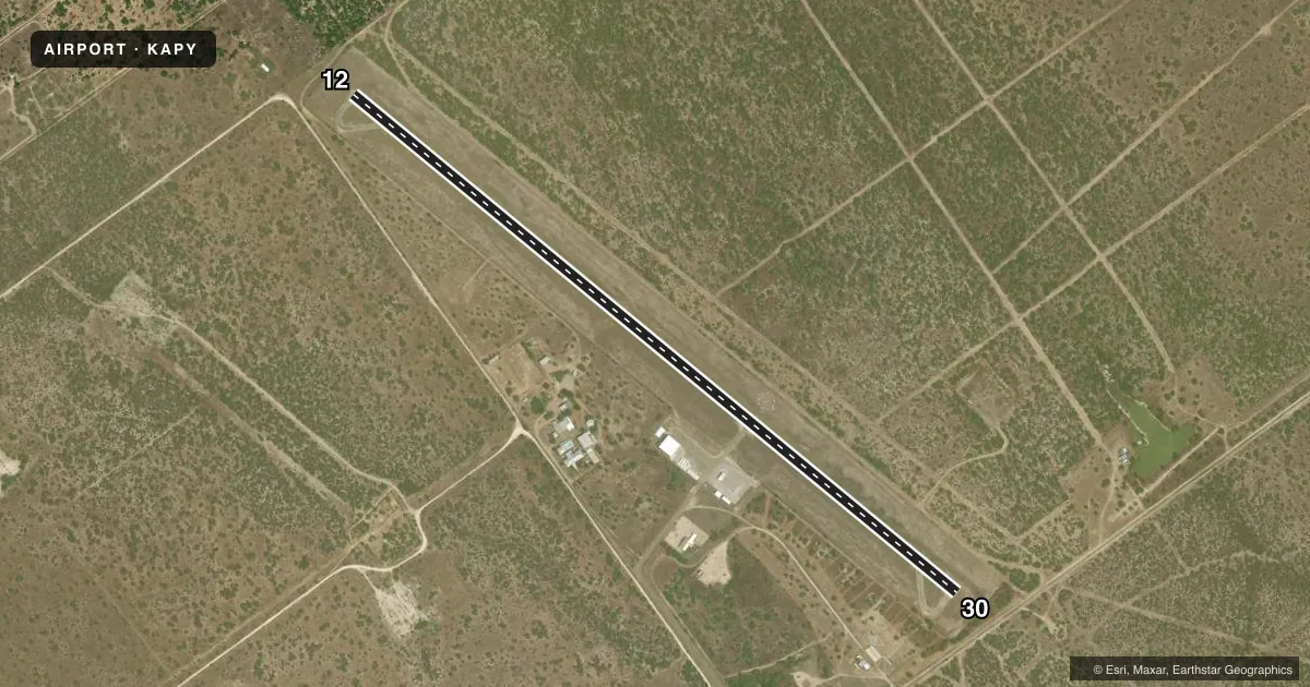
Airport sketch
Runways drawn to scale from FAA survey coordinates, rendered over satellite imagery. Not for navigation.
Approaches & charts
Services on the field
Fuel grades, oxygen, maintenance, ramp storage and lighting — as declared to the FAA by the airport operator.
Fuel & services
- Fuel
- 100LLA
Ramp & ground
- Transient storage
- Tie-down
- Hangar
- Lighting schedule
- SEE RMK
- Beacon schedule
- SS-SR
- Beacon
- White / Green (civil land)(WG)
- Wind indicator
- Lighted
- Segmented circle
- Yes
Fuel & FBOs
Cheapest 100LL and Jet A on the field and nearby. Always confirm with the FBO before taxi.
Airport notes
Surface conditions, obstructions, local procedures, lighting outages and other notes published with each FAA cycle.
General notes
- FOR CD CTC HOUSTON ARTCC AT 281-230-5622.
Lighting notes
- DUSK-DAWN. MIRL RWY 12/30 PRESET MED INTST; TO INCR INTST ACTVT - CTAF.
Approach & departure obstructions
- 1212 FT TREES, 190 FT DSTC,125 FT L/R.
- 3020 FT TREES, 195 FT DSTC, 125 FT L/R.
- 12OBSTN CLEARANCE SLOPE 8:1 TO DSPLCD THR.
- 30OBSTN CLEARANCE SLOPE 16:1 TO DSPLCD THR.
Other notes
- THIS AIRPORT HAS BEEN SURVEYED BY THE NATIONAL GEODETIC SURVEY.
VFR map & nearby airports
VFR sectional. Tap any ICAO chip to open that airport.
Key facts · KAPY
Answer card- ICAO
- KAPY
- Name
- ZAPATA COUNTY
- Location
- ZAPATA, TEXAS
- Elevation
- 422.1 ft MSL
- Traffic pattern altitude
- 1,422.1 ft MSL (1,000 AGL)
- Control tower
- Non-towered (use CTAF)
- Total runways
- 1
- Longest runway
- 12/30 · 5,000 ft
- Published ILS approaches
- 0
- Published frequencies
- 2
- Magnetic variation
- 8°
- Current flight rules
- VFR
- Current wind
- 150° at 10 kt
- Favored runway now
- RWY 12
Zapata County Airport sits in Zapata, Texas. The field elevation is 422.1 ft MSL. It has one runway, 12/30, at 5,000 ft on asphalt. There is no control tower. CTAF and UNICOM are both 122.7. No ILS approaches are published here, so plan with the current chart and your own weather minimums in mind.
The published pattern altitude is not listed, so use the standard 1,000 ft AGL pattern unless local procedures or the current Chart Supplement say otherwise. The on-field FBO is Zapata County Airport. It carries AVGAS 100LL and JET A. Call ahead at (956) 765-4453 if you need current service details.
A few remarks matter for the first-time pilot. Runway 12 has 12 ft trees about 190 ft from the runway with trees left and right of centerline. Runway 30 has 20 ft trees about 195 ft from the runway with trees left and right of centerline. The published obstacle clearance slopes are 8 to 1 to the displaced threshold on runway 12 and 16 to 1 to the displaced threshold on runway 30. Runway lights are medium intensity. They are preset from dusk to dawn. You can increase intensity by keying the CTAF. For clearance delivery, contact Houston ARTCC at 281-230-5622.