METAR & TAF KLRD
Current METAR
Observed 12:56Z
KLRD 271256Z 15012KT 10SM CLR 26/22 A2993 RMK AO2 SLP128 T02610222
- Wind
- 150° @ 12 kt
- Visibility
- 10 SM
- Temp / Dew
- 26°C / 22°C
- Altimeter
- 29.93 inHg
- Clouds
- CLR
- Density alt
- 1,938 ft
- Ceiling
- Unlimited
- Rules
- VFR
Airport info & contacts
Manager on record, flight service, ARTCC, attendance schedule and pattern altitude — published by the FAA and refreshed every 28 days.
Location
- From city
- 3 NM NE
- VFR sectional
- BROWNSVILLE
- ARTCC
- ZHU · HOUSTON
- NOTAM facility
- LRD (NOTAM-D)
Airport manager
- Name
- GILBERTO SANCHEZ
- Phone
- 956-795-2000
- Address
- 5210 BOB BULLOCK LOOP, LAREDO TX 78041
Flight service · Hours
- FSS SJT
- SAN ANGELO1-800-WX-BRIEF
- Attendance
- ALL
Frequencies
Tap any row to copy the frequency to your clipboard.
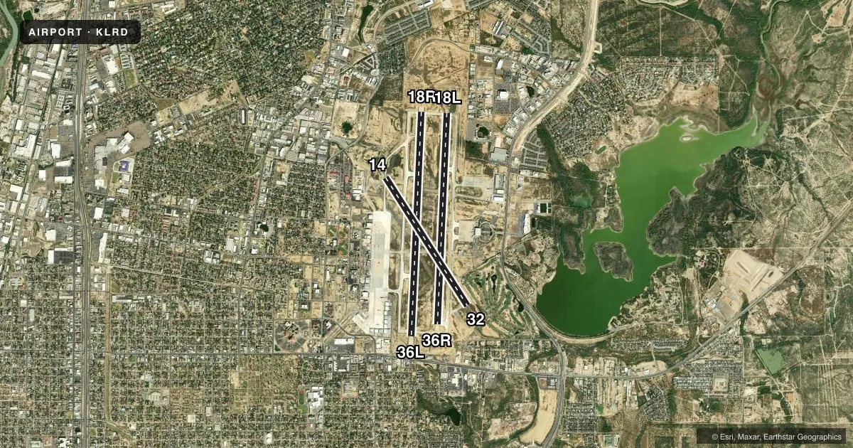
Runways & pattern
Full pagePattern entry · RWY 14
LEFT TRAFFIC| Runway | Heading (°M) | Length | Surface | Traffic |
|---|---|---|---|---|
| 18R/36L | 178° / 358° | 8,743 ft | CONC | 36L R |
| 18L/36R | 178° / 358° | 8,236 ft | CONC | 36R R |
| 14/32Favored | 142° / 322° | 5,927 ft | CONC | 32 R |
Runway end performance
| End | TORA | TODA | ASDA | LDA | VGSI | Approach lights | Obstruction |
|---|---|---|---|---|---|---|---|
| 18R | 8,743' | 8,743' | 8,743' | 8,743' | PAPI 4-box left(3°) | MALSR | — |
| 36L | 8,743' | 8,743' | 8,743' | 8,623' | PAPI 4-box left(3°) | — | — |
| 18L | 8,236' | 8,236' | 8,236' | 8,236' | PAPI 4-box left(3°) | — | — |
| 36R | 8,236' | 8,236' | 8,236' | 8,236' | — | — | — |
| 14 | 5,927' | 5,927' | 5,927' | 5,927' | VASI 4-box left(3°) | — | — |
| 32 | 5,927' | 5,927' | 5,927' | 5,927' | VASI 4-box left(3°) | — | 12', road, 201' from thr, 250' R of cntrln, slope 0 |
Declared distances in feet. TORA = takeoff run available, TODA = takeoff distance, ASDA = accelerate-stop, LDA = landing distance.
Airport sketch
Runways drawn to scale from FAA survey coordinates, rendered over satellite imagery. Not for navigation.
Approaches & charts
ILS · 1
Services on the field
Fuel grades, oxygen, maintenance, ramp storage and lighting — as declared to the FAA by the airport operator.
Fuel & services
- Fuel
- 100LLA
- Oxygen (bottled)
- Low pressure
- Oxygen (bulk)
- Low pressure
- Power plant repair
- Major
- Other services
- AFRT,AVNCS,CARGO,CHTR,INSTR,RNTL,SALES
Ramp & ground
- Transient storage
- Tie-down
- Hangar
- Landing fee
- No fee published
- Customs
- Available
- Lighting schedule
- SEE RMK
- Beacon schedule
- SS-SR
- Beacon
- White / Green (civil land)(WG)
- Wind indicator
- Lighted
- Segmented circle
- Yes
Fuel & FBOs
Cheapest 100LL and Jet A on the field and nearby. Always confirm with the FBO before taxi.
Airport notes
Surface conditions, obstructions, local procedures, lighting outages and other notes published with each FAA cycle.
General notes
- RWY 14/32 RSTRD TO ACFT LESS THAN 60000 LBS DTW.
- TWY C CLSD BTN RWY 18L/36R & RWY 18R INDEFLY.
- FEDERAL INSPECTION STATION IS LCTD ON THE WEST GENERAL AVIATION/CARGO APRON.
- FOR CD IF UNA TO CTC ON FSS FREQ, CTC HOUSTON ARTCC AT 281-230-5622.
- BIRDS ON AND INVOF ARPT.
- LNDG FEE ASSESSED FOR ALL ACFT EXC FEDERAL, MIL AND BASED ACFT.
- FEDERAL INSPECTION STATION FEE.
Lighting notes
- WHEN ATCT CLSD ACTVT MALSR RWY 18R - CTAF. MIRL RWY 14/32; HIRL RWYS 18L/36R & 18R/36L PRESET MED INTST.
Fuel notes
- 100LLJP4 FUEL AVBL.
Runway surface & condition
- 14/32PCR VALUE: 98/R/D/W/T
- 18L/36RPCR VALUE: 600/R/D/W/T
- 18R/36LPCR VALUE: 684/R/D/W/T
- 14/32RWY 14/32 NOT AVBL FOR PART 121/PART 380 OPS WITH SKED PAX CARRYING OPS MORE THAN 9 PAX SEATS AND NON-SKED PAX CARRYING OPS MORE THAN 30 PAX SEATS.
Arresting gear
- 18R_EMASENGINEERED MATERIALS ARRESTING SYSTEM (EMAS) 363 FT IN LENGTH BY 170 FT IN WIDTH LCTD AT THE DER 18R.
VFR map & nearby airports
VFR sectional. Tap any ICAO chip to open that airport.
Key facts · KLRD
Answer card- ICAO
- KLRD
- Name
- LAREDO INTL
- Location
- LAREDO, TEXAS
- Elevation
- 508 ft MSL
- Traffic pattern altitude
- 1,508 ft MSL (1,000 AGL)
- Control tower
- Towered · 0600-2400
- Total runways
- 3
- Longest runway
- 18R/36L · 8,743 ft
- Published ILS approaches
- 1
- Published frequencies
- 7
- Magnetic variation
- 5°
- Current flight rules
- VFR
- Current wind
- 150° at 12 kt
- Favored runway now
- RWY 14
Laredo Intl sits in Laredo, Texas. Field elevation is 508 ft MSL. The airport has three concrete runways. The longest is 8,743 ft on 18R/36L. The tower is open 0600-2400. One ILS is published for runway 18R.
Pattern altitude is not published in the facts. Use the current FAA Chart Supplement before you fly. The field is busy enough to expect controlled airport procedures. Expect ramp coordination. Expect normal tower work during the published hours. When the tower is closed, runway 18R lighting is activated on CTAF. Runway 14/32 has medium intensity runway lights. The high intensity lights for 18L/36R and 18R/36L are preset to medium intensity.
Signature Aviation is on the field. It carries 100LL and Jet A. Barker Ground Services is also on the field. It carries 100LL, Jet A and Jet A Prist. A federal inspection station is on the west general aviation and cargo ramp. A landing fee applies to all aircraft except federal, military and based aircraft. Taxiway C is closed between 18L/36R and 18R indefinitely. Birds are reported on and near the airport. Keep that in mind on arrival and departure.