METAR & TAF KCZT
Current METAR
Observed 16:35Z
KCZT 271635Z AUTO 17007KT 10SM 33/21 A2997 RMK AO2
- Wind
- 170° @ 7 kt
- Visibility
- 10 SM
- Temp / Dew
- 33°C / 21°C
- Altimeter
- 29.97 inHg
- Clouds
- Clear
- Density alt
- 2,840 ft
- Ceiling
- Unlimited
- Rules
- VFR
Airport info & contacts
Manager on record, flight service, ARTCC, attendance schedule and pattern altitude — published by the FAA and refreshed every 28 days.
Location
- From city
- 2 NM E
- VFR sectional
- SAN ANTONIO
- ARTCC
- ZHU · HOUSTON
- NOTAM facility
- CZT (NOTAM-D)
Airport manager
- Name
- ERNEST MARTINEZ, JR
- Phone
- 830-876-2967
- Address
- PO BOX 432, CARRIZO SPRINGS TX 78834
Flight service · Hours
- FSS SJT
- SAN ANGELO1-800-WX-BRIEF
- Attendance
- 0800 - 1700
Frequencies
Tap any row to copy the frequency to your clipboard.
Runways & pattern
Full pagePattern entry · RWY 13
LEFT TRAFFICRunway end performance
| End | TORA | TODA | ASDA | LDA | VGSI | Approach lights | Obstruction |
|---|---|---|---|---|---|---|---|
| 13 | — | — | — | — | PAPI 4-box left(3°) | — | 35', pline, 640' from thr, 188' R of cntrln, slope 12 |
| 31 | — | — | — | — | PAPI 4-box left(3°) | — | 42', pole, 1340' from thr, 180' R of cntrln, slope 27 |
Declared distances in feet. TORA = takeoff run available, TODA = takeoff distance, ASDA = accelerate-stop, LDA = landing distance.
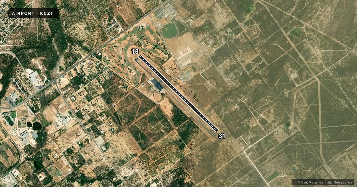
Airport sketch
Runways drawn to scale from FAA survey coordinates, rendered over satellite imagery. Not for navigation.
Approaches & charts
Services on the field
Fuel grades, oxygen, maintenance, ramp storage and lighting — as declared to the FAA by the airport operator.
Fuel & services
- Fuel
- 100LLA+
- Oxygen (bottled)
- Not available
- Oxygen (bulk)
- Not available
- Other services
- AMB
Ramp & ground
- Transient storage
- Tie-down
- Hangar
- Landing fee
- Yes
- Customs
- Not available
- Lighting schedule
- SS-SR
- Beacon schedule
- SS-SR
- Beacon
- White / Green (civil land)(WG)
- Wind indicator
- Lighted
- Segmented circle
- Yes
Fuel & FBOs
Cheapest 100LL and Jet A on the field and nearby. Always confirm with the FBO before taxi.
Airport notes
Surface conditions, obstructions, local procedures, lighting outages and other notes published with each FAA cycle.
General notes
- DEER ON OR INVOF ARPT
- FOR CD CTC HOUSTON ARTCC AT 281-230-5622.
- RWY 31, UNMKD, UNLGTD ELECT TRANSMISSION LINES UNDERLIE APCH.
Fuel notes
- 100LLFUEL AVBL ON REQ 830-876-2967.
Other notes
- PRE DATES THE ACT.
VFR map & nearby airports
VFR sectional. Tap any ICAO chip to open that airport.
Key facts · KCZT
Answer card- ICAO
- KCZT
- Name
- DIMMIT COUNTY
- Location
- CARRIZO SPRINGS, TEXAS
- Elevation
- 598.1 ft MSL
- Traffic pattern altitude
- 1,598.1 ft MSL (1,000 AGL)
- Control tower
- Non-towered (use CTAF)
- Total runways
- 1
- Longest runway
- 13/31 · 5,003 ft
- Published ILS approaches
- 0
- Published frequencies
- 2
- Magnetic variation
- 7°
- Current flight rules
- VFR
- Current wind
- 170° at 7 kt
- Favored runway now
- RWY 13
Dimmit County Airport sits in Carrizo Springs, Texas. The field elevation is 598.1 ft MSL. It has one runway. Runway 13/31 is 5,003 ft of asphalt. The airport is non-towered. CTAF and UNICOM are both 122.8. No ILS approaches are published here.
The published pattern altitude is not listed. Use the standard 1,000 ft AGL unless local procedures or the current Chart Supplement say otherwise. That puts the pattern at about 1,598 ft MSL based on the field elevation. Runway headings are magnetic. Runway 13 is 134°. Runway 31 is 314°.
Blue Nest Aviation is on the field. It carries JET_A_PRIST. Fuel on request is noted in the published remarks. Deer are reported on or near the airport. Runway 31 is unmarked and unlighted. Electrical transmission lines lie under the approach. That makes a careful arrival important, especially if you are coming in at night or in low light. The airport also predates the tower era, so expect a simple non-towered flow. Check the current FAA Chart Supplement and call the airport operator or Blue Nest Aviation before departure if you need anything current.