METAR & TAF 5T9
Current METAR
Observed 13:35Z
K5T9 271335Z AUTO 14006KT 9SM CLR 27/23 A2993 RMK A01
- Wind
- 140° @ 6 kt
- Visibility
- 9 SM
- Temp / Dew
- 27°C / 23°C
- Altimeter
- 29.93 inHg
- Clouds
- CLR
- Density alt
- 2,528 ft
- Ceiling
- Unlimited
- Rules
- VFR
Airport info & contacts
Manager on record, flight service, ARTCC, attendance schedule and pattern altitude — published by the FAA and refreshed every 28 days.
Location
- From city
- 8 NM N
- VFR sectional
- SAN ANTONIO
- ARTCC
- ZHU · HOUSTON
- NOTAM facility
- SJT (NOTAM-D)
Airport manager
- Name
- GABRIEL VILLASENOR
- Phone
- 830-773-9636
- Address
- 500 QUARRY STREET, SUITE 3, EAGLE PASS TX 78852
Flight service · Hours
- FSS SJT
- SAN ANGELO1-800-WX-BRIEF
- Attendance
- MON-FRI · 0830-1400
- SAT-SUN · 1000-1600
Frequencies
Tap any row to copy the frequency to your clipboard.
Runways & pattern
Full pagePattern entry · RWY 13
LEFT TRAFFICRunway end performance
| End | TORA | TODA | ASDA | LDA | VGSI | Approach lights | Obstruction |
|---|---|---|---|---|---|---|---|
| 13 | — | — | — | — | — | — | 12', brush, 340' from thr, 170' R of cntrln, slope 11 |
Declared distances in feet. TORA = takeoff run available, TODA = takeoff distance, ASDA = accelerate-stop, LDA = landing distance.
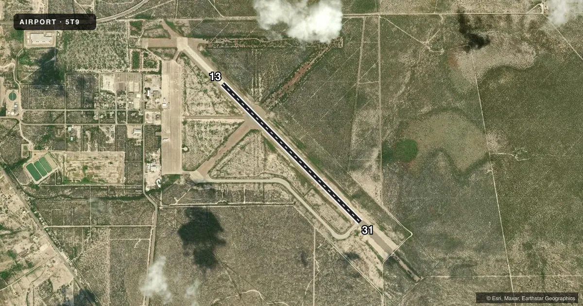
Airport sketch
Runways drawn to scale from FAA survey coordinates, rendered over satellite imagery. Not for navigation.
Approaches & charts
Services on the field
Fuel grades, oxygen, maintenance, ramp storage and lighting — as declared to the FAA by the airport operator.
Fuel & services
- Fuel
- 100LLA+
- Oxygen (bottled)
- Not available
- Oxygen (bulk)
- Not available
- Airframe repair
- Not available
- Power plant repair
- Not available
Ramp & ground
- Transient storage
- Tie-down
- Customs
- Available
- Lighting schedule
- SEE RMK
- Beacon schedule
- SS-SR
- Beacon
- White / Green (civil land)(WG)
- Wind indicator
- Lighted
- Segmented circle
- Yes
Fuel & FBOs
Cheapest 100LL and Jet A on the field and nearby. Always confirm with the FBO before taxi.
Airport notes
Surface conditions, obstructions, local procedures, lighting outages and other notes published with each FAA cycle.
General notes
- FLIGHT NOTIFICATION SERVICE (ADCUS) AVBL.
- FOR CD CTC LAUGHLIN APCH AT 830-298-5192, WHEN APCH CLSD CTC HOUSTON ARTCC AT 281-230-5622.
Lighting notes
- DUSK-DAWN. MIRL RWY 13/31 PRESET LOW INTST; TO INCR INTST ACTVT - CTAF.
Approach & departure obstructions
- 13RWY MRKGS FADED.
Other notes
- MANAGERAMGR CELL 830-213-9760.
- 13/31EXTSV CRACKING.
VFR map & nearby airports
VFR sectional. Tap any ICAO chip to open that airport.
Key facts · 5T9
Answer card- ICAO
- 5T9
- Name
- MAVERICK COUNTY MEML INTL
- Location
- EAGLE PASS, TEXAS
- Elevation
- 887.3 ft MSL
- Traffic pattern altitude
- 1,887.3 ft MSL (1,000 AGL)
- Control tower
- Non-towered (use CTAF)
- Total runways
- 1
- Longest runway
- 13/31 · 5,506 ft
- Published ILS approaches
- 0
- Published frequencies
- 4
- Magnetic variation
- 6°
- Current flight rules
- VFR
- Current wind
- 140° at 6 kt
- Favored runway now
- RWY 13
Maverick County Meml Intl is in Eagle Pass, Texas. Field elevation is 887.3 ft MSL. The airport has one runway, 13/31, which is 5,506 ft long with asphalt pavement. There is no control tower. No ILS approaches are published here.
Pattern altitude is not published. Use the standard 1,000 ft AGL pattern for light piston operations unless the current Chart Supplement says otherwise. The field sits near the border region, so expect to stay sharp on radio work and local traffic flow. Runway 13 has faded markings. The runway also has extensive cracking, so plan your landing and rollout with the surface condition in mind.
Lighting is available from dusk to dawn. Runway 13/31 medium intensity lights are preset to low intensity. Use CTAF to increase intensity if needed. Bravo Aero Service is on field. It carries 100LL and Jet A. For clearance delivery, contact Laughlin Approach at 830-298-5192. When Approach is closed, contact Houston ARTCC at 281-230-5622. If you need current operational details, check the current FAA Chart Supplement or call the airport operator directly.