METAR & TAF KECU
Current METAR
Observed 22:35Z
KECU 262235Z AUTO 15011KT 10SM CLR 32/16 A3009 RMK AO2
- Wind
- 150° @ 11 kt
- Visibility
- 10 SM
- Temp / Dew
- 32°C / 16°C
- Altimeter
- 30.09 inHg
- Clouds
- CLR
- Density alt
- 4,771 ft
- Ceiling
- Unlimited
- Rules
- VFR
Airport info & contacts
Manager on record, flight service, ARTCC, attendance schedule and pattern altitude — published by the FAA and refreshed every 28 days.
Location
- From city
- 4 NM SE
- VFR sectional
- SAN ANTONIO
- ARTCC
- ZHU · HOUSTON
- NOTAM facility
- ECU (NOTAM-D)
Airport manager
- Name
- JASON ARP
- Phone
- 830-683-7193
- Address
- BOX 348ROCKSPRINGS TX 78880
Flight service · Hours
- FSS SJT
- SAN ANGELO1-800-WX-BRIEF
- Attendance
- Unattended
Frequencies
Tap any row to copy the frequency to your clipboard.
Runways & pattern
Full pagePattern entry · RWY 14
LEFT TRAFFICRunway end performance
| End | TORA | TODA | ASDA | LDA | VGSI | Approach lights | Obstruction |
|---|---|---|---|---|---|---|---|
| 14 | — | — | — | — | — | — | 25', trees, 201' from thr, 0' R of cntrln, slope 0 |
| 32 | — | — | — | — | — | — | 23', trees, 780' from thr, 200' R of cntrln, slope 25 |
Declared distances in feet. TORA = takeoff run available, TODA = takeoff distance, ASDA = accelerate-stop, LDA = landing distance.
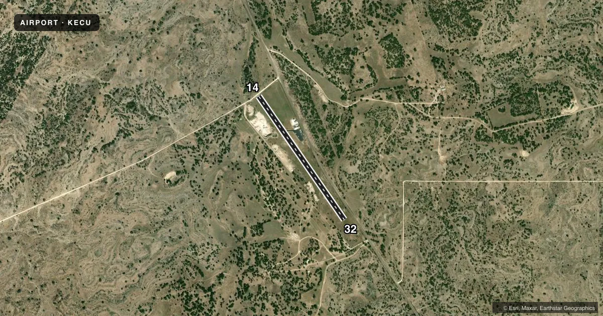
Airport sketch
Runways drawn to scale from FAA survey coordinates, rendered over satellite imagery. Not for navigation.
Approaches & charts
Services on the field
Fuel grades, oxygen, maintenance, ramp storage and lighting — as declared to the FAA by the airport operator.
Fuel & services
- Fuel
- Not available
- Airframe repair
- Not available
- Power plant repair
- Not available
Ramp & ground
- Transient storage
- Tie-down
- Landing fee
- No fee published
- Lighting schedule
- SS-SR
- Beacon schedule
- SS-SR
- Beacon
- White / Green (civil land)(WG)
- Wind indicator
- Yes
- Segmented circle
- Yes
Fuel & FBOs
Cheapest 100LL and Jet A on the field and nearby. Always confirm with the FBO before taxi.
Airport notes
Surface conditions, obstructions, local procedures, lighting outages and other notes published with each FAA cycle.
General notes
- GATE ACES USE FLD ELEV.
- FOR CD CTC LAUGHLIN APCH AT 830-298-5192, WHEN APCH CLSD CTC HOUSTON ARTCC AT 281-230-5622.
- GRAVEL PIT ADJ TO RWY W SIDE, 12 FT DIRT PILES 156 FT FM RWY CL.
Approach & departure obstructions
- 148 FT MKD FENCE, 30 FT DSTC.
- 14NGT OPN DSPLCD THR LGTS ARE 288 FT FM RWY END.
- 14MRKGS FADED.
- 32MRKGS FADED.
- 1420:1 TO DSPLCD THR OVR 25 FT TREES, 600 FT DSTC, 0 B.
Other notes
- THIS AIRPORT HAS BEEN SURVEYED BY THE NATIONAL GEODETIC SURVEY.
- MANAGERROAD AND BRIDGE SUPT.
VFR map & nearby airports
VFR sectional. Tap any ICAO chip to open that airport.
Key facts · KECU
Answer card- ICAO
- KECU
- Name
- EDWARDS COUNTY
- Location
- ROCKSPRINGS, TEXAS
- Elevation
- 2,372.2 ft MSL
- Traffic pattern altitude
- 3,372.2 ft MSL (1,000 AGL)
- Control tower
- Non-towered (use CTAF)
- Total runways
- 1
- Longest runway
- 14/32 · 4,050 ft
- Published ILS approaches
- 0
- Published frequencies
- 4
- Magnetic variation
- 7°
- Current flight rules
- VFR
- Current wind
- 150° at 11 kt
- Favored runway now
- RWY 14
Edwards County Airport is in Rocksprings, Texas. The field elevation is 2,372.2 ft MSL. It has one runway. Runway 14/32 is 4,050 ft long with an asphalt surface. The airport is non-towered, so expect self-announce traffic on CTAF 122.9 unless ATC gives you other instructions.
No ILS approaches are published here. Pattern altitude is not published in the facts, so use the standard 1,000 ft AGL for light piston operations unless the current FAA Chart Supplement says otherwise. The published remarks matter here. Runway 14 has displaced threshold lighting at night. The threshold is 288 ft from the runway end. Runway 14 and Runway 32 markings are faded. There is also a gravel pit on the west side with dirt piles close to the runway. Runway 14 has a marked fence near the end. Trees on the approach side affect the threshold clearance path.
There are no on-field FBOs listed in the facts. Contact the airport operator directly before arrival, or call the field on CTAF/UNICOM for current FBO availability. For clearance delivery, contact Laughlin Approach at 830-298-5192. When Approach is closed, contact Houston ARTCC at 281-230-5622. This airport sits at higher elevation, so performance planning matters on warm Texas days. Check density altitude, runway length and your takeoff numbers before you go.