METAR & TAF 10X
10X does not publish a METAR.
Showing the nearest reporting station: KUVA (GARNER FLD) · 24.5 NM away. Conditions at 10X may differ.
METAR · KUVA
Observed 13:15Z
KUVA 271315Z AUTO 08006KT 7SM CLR 24/23 A2998 RMK AO2 T02410229
- Wind
- 080° @ 6 kt
- Visibility
- 7 SM
- Temp / Dew
- 24°C / 23°C
- Altimeter
- 29.98 inHg
- Clouds
- CLR
- Density alt
- 2,624 ft
- Ceiling
- Unlimited
- Rules
- VFR
Airport info & contacts
Manager on record, flight service, ARTCC, attendance schedule and pattern altitude — published by the FAA and refreshed every 28 days.
Location
- From city
- 23 NM NW
- VFR sectional
- SAN ANTONIO
- ARTCC
- ZHU · HOUSTON
Airport manager
- Name
- ANGELA REYNOLDS
- Phone
- 830-275-4962
- Address
- 1946 PRIVATE ROAD 2485, UVALDE TX 78801-6760
Flight service · Hours
- FSS SJT
- SAN ANGELO1-800-WX-BRIEF
- Attendance
- Unattended
Frequencies
Tap any row to copy the frequency to your clipboard.
Runways & pattern
Full pagePattern entry · RWY 35
RIGHT TRAFFICRunway end performance
| End | TORA | TODA | ASDA | LDA | VGSI | Approach lights | Obstruction |
|---|---|---|---|---|---|---|---|
| 17 | — | — | — | — | PAPI 2-box left(3.75°) | — | — |
| 35 | — | — | — | — | PAPI 2-box left(3.3°) | — | 3', fence, 230' from thr, 0' R of cntrln, slope 10 |
Declared distances in feet. TORA = takeoff run available, TODA = takeoff distance, ASDA = accelerate-stop, LDA = landing distance.
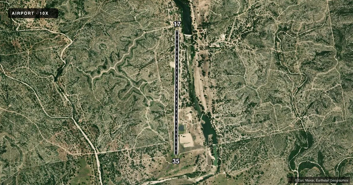
Airport sketch
Runways drawn to scale from FAA survey coordinates, rendered over satellite imagery. Not for navigation.
Approaches & charts
Services on the field
Fuel grades, oxygen, maintenance, ramp storage and lighting — as declared to the FAA by the airport operator.
Fuel & services
- Fuel
- A1+
- Oxygen (bottled)
- Not available
- Oxygen (bulk)
- Not available
- Airframe repair
- Not available
- Power plant repair
- Not available
Ramp & ground
- Transient storage
- Tie-down
- Lighting schedule
- SEE RMK
- Wind indicator
- Yes
- Segmented circle
- No
Fuel & FBOs
Cheapest 100LL and Jet A on the field and nearby. Always confirm with the FBO before taxi.
Airport notes
Surface conditions, obstructions, local procedures, lighting outages and other notes published with each FAA cycle.
General notes
- ACFT WINGSPAN RSTRD TO 70 FT.
- TURBINE PWRD ACFT LDGS AND TKOFS 30 MIN BFR SR TIL 30 MIN AFT SS.
- ASRI 130.8
- TRNG TGL PROHIBITED. HEL TRNG PROHIBITED.
- OVNGT PRKG LTD DUE TO LTD RAMP SPACE. CDN PRIOR TO LDG, 830-275-4962, INFO@OXRANCHAIRPORT.COM.
- COML AND STUDENT TRNG OPNS BY PMT ONLY.
- PPR FOR ACFT CERTD FOR 90500 TOG.
- WILDLIFE ON & INVOF ARPT.
- FOR CD CTC DEL RIO APCH AT 830-298-5192, WHEN APCH CLSD CTC HOUSTON ARTCC AT 281-230-5622.
- 15 FT. BRUSH, 6 FT BERM, 8 FT FENCE IN PRI SFC.
Lighting notes
- ACTVT PAPI RWY 17 & 35; MIRL RWY 17/35 - CTAF.
Approach & departure obstructions
- 1725 FT TREE, 0 FT DSTC, 118 FT R.
- 353 FT FENCE, 0-199 FT DSTC, 100 FT R AND L.
Other notes
- MANAGERNICK@NICKTYSON.COM
- OWNERBRENT@OXLEY.COM
VFR map & nearby airports
VFR sectional. Tap any ICAO chip to open that airport.
Key facts · 10X
Answer card- ICAO
- 10X
- Name
- OX RANCH
- Location
- UVALDE, TEXAS
- Elevation
- 1,305.3 ft MSL
- Traffic pattern altitude
- 2,305.3 ft MSL (1,000 AGL)
- Control tower
- Non-towered (use CTAF)
- Total runways
- 1
- Longest runway
- 17/35 · 5,744 ft
- Published ILS approaches
- 0
- Published frequencies
- 1
- Magnetic variation
- 4°
- Current flight rules
- VFR
- Current wind
- 080° at 6 kt
- Favored runway now
- RWY 35
OX Ranch Airport sits near Uvalde, Texas. Field elevation is 1,305.3 ft MSL. The airport has one runway. Runway 17/35 is 5,744 ft long with a concrete surface. There is no control tower. CTAF is 122.8. No ILS approaches are published here.
Pattern altitude is not published. Use the standard 1,000 ft AGL pattern unless the current Chart Supplement says otherwise. That puts the light piston pattern at about 2,305 ft MSL based on the field elevation. The airport sits in a rural area with wildlife present on and near the field. The published remarks also call out obstructions near both runway ends, so keep a close eye on the runway environment on final and in the flare.
There are no on-field FBOs listed, so plan ahead for services before you go. Overnight parking is limited because ramp space is tight. Coordinate before landing if you need to stay. Turbine aircraft operations are restricted from 30 minutes before sunrise until 30 minutes after sunset. Commercial and student training operations are by permit only. Touch-and-go training is prohibited. Helicopter training is prohibited. For clearance delivery, contact Del Rio Approach when it is open. If it is closed, use Houston ARTCC. The runway lights and PAPI are activated from CTAF.