METAR & TAF 11T
11T does not publish a METAR.
Showing the nearest reporting station: KJCT (KIMBLE COUNTY) · 23.6 NM away. Conditions at 11T may differ.
METAR · KJCT
Observed 18:12Z
KJCT 271812Z AUTO 15006G15KT 10SM FEW002 33/22 A2999 RMK AO2 T03330222
- Wind
- 150° @ 6G15 kt
- Visibility
- 10 SM
- Temp / Dew
- 33°C / 22°C
- Altimeter
- 29.99 inHg
- Clouds
- FEW
- Density alt
- 4,974 ft
- Ceiling
- Unlimited
- Rules
- VFR
Airport info & contacts
Manager on record, flight service, ARTCC, attendance schedule and pattern altitude — published by the FAA and refreshed every 28 days.
Location
- From city
- 26 NM ESE
- VFR sectional
- SAN ANTONIO
- ARTCC
- ZHU · HOUSTON
- NOTAM facility
- SJT (NOTAM-D)
Airport manager
- Name
- CARL LANG
- Phone
- 325-226-3445
- Address
- 625 WEATHERBY RD, HARPER TX 78631
Flight service · Hours
- FSS SJT
- SAN ANGELO1-800-WX-BRIEF
- Attendance
- Unattended
Frequencies
Tap any row to copy the frequency to your clipboard.
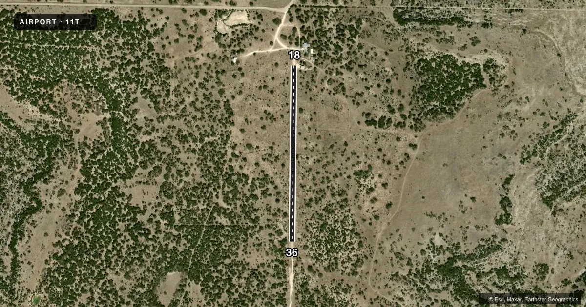
Runways & pattern
Full pagePattern entry · RWY 18
RIGHT TRAFFICAirport sketch
Runways drawn to scale from FAA survey coordinates, rendered over satellite imagery. Not for navigation.
Approaches & charts
Services on the field
Fuel grades, oxygen, maintenance, ramp storage and lighting — as declared to the FAA by the airport operator.
Fuel & services
- Fuel
- Not available
Ramp & ground
- Transient storage
- Not published
Fuel & FBOs
Cheapest 100LL and Jet A on the field and nearby. Always confirm with the FBO before taxi.
Airport notes
Surface conditions, obstructions, local procedures, lighting outages and other notes published with each FAA cycle.
General notes
- RWY SFC MAY BE UNEVEN AND HAVE SMALL MESQUITE.
- WILDLIFE AND/OR LIVESTOCK MAY BE PRESENT ON OR NEAR THE RWY. USE CAUTION; PHYSICAL BARRIER/FENCING MAY NOT PREVENT ENTRY.
Other notes
- OWNERLANGRANCHES@HOTMAIL.COM
VFR map & nearby airports
VFR sectional. Tap any ICAO chip to open that airport.
Key facts · 11T
Answer card- ICAO
- 11T
- Name
- ROCKING L
- Location
- SONORA, TEXAS
- Elevation
- 2,339 ft MSL
- Traffic pattern altitude
- 3,339 ft MSL (1,000 AGL)
- Control tower
- Non-towered (use CTAF)
- Total runways
- 1
- Longest runway
- 18/36 · 2,432 ft
- Published ILS approaches
- 0
- Published frequencies
- 1
- Magnetic variation
- –
- Current flight rules
- VFR
- Current wind
- 150° at 6 kt
- Favored runway now
- RWY 18
Rocking L is in Sonora, Texas. The field elevation is 2,339 ft MSL. It has one runway, 18/36, which is 2,432 ft long and surfaced in gravel. This is a non-towered airport. CTAF is 122.9.
No ILS approaches are published here. Pattern altitude is not published, so use standard light piston traffic pattern planning at 1,000 ft AGL unless the current FAA Chart Supplement says otherwise. The runway is short. Plan performance with the elevation in mind. Sonora sits in west-central Texas, so density altitude can matter on warm days.
Published remarks call out an uneven runway surface with small mesquite present. Wildlife or livestock may also be on or near the runway. That makes a careful low pass and a good walk-around worth your time before committing. The remarks also say to contact the owner at langranches@hotmail.com for airport-specific coordination. There are no on-field FBOs listed. Check current field details before you go if you need services or local operating notes.