METAR & TAF KSOA
Current METAR
Observed 13:15Z
KSOA 271315Z AUTO 16009KT 10SM CLR 24/21 A3005 RMK AO2
- Wind
- 160° @ 9 kt
- Visibility
- 10 SM
- Temp / Dew
- 24°C / 21°C
- Altimeter
- 30.05 inHg
- Clouds
- CLR
- Density alt
- 3,572 ft
- Ceiling
- Unlimited
- Rules
- VFR
Airport info & contacts
Manager on record, flight service, ARTCC, attendance schedule and pattern altitude — published by the FAA and refreshed every 28 days.
Location
- From city
- 1 NM N
- VFR sectional
- SAN ANTONIO
- ARTCC
- ZHU · HOUSTON
- NOTAM facility
- SOA (NOTAM-D)
Airport manager
- Name
- PETER R DURAN
- Phone
- 325-387-2558
- Address
- 201 E MAIN ST, SONORA TX 76950
Flight service · Hours
- FSS SJT
- SAN ANGELO1-800-WX-BRIEF
- Attendance
- Unattended
Frequencies
Tap any row to copy the frequency to your clipboard.
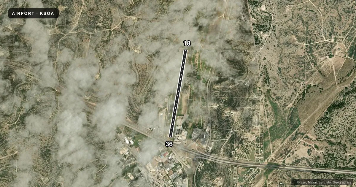
Runways & pattern
Full pagePattern entry · RWY 18
LEFT TRAFFICRunway end performance
| End | TORA | TODA | ASDA | LDA | VGSI | Approach lights | Obstruction |
|---|---|---|---|---|---|---|---|
| 18 | — | — | — | — | PSIL(3°) | — | 40', trees, 564' from thr, 105' R of cntrln, slope 9 |
| 36 | — | — | — | — | PSIL(3°) | — | 50', pline, 200' from thr, 239' R of cntrln, slope 0 |
Declared distances in feet. TORA = takeoff run available, TODA = takeoff distance, ASDA = accelerate-stop, LDA = landing distance.
Airport sketch
Runways drawn to scale from FAA survey coordinates, rendered over satellite imagery. Not for navigation.
Approaches & charts
Services on the field
Fuel grades, oxygen, maintenance, ramp storage and lighting — as declared to the FAA by the airport operator.
Fuel & services
- Fuel
- Not available
- Oxygen (bottled)
- Not available
- Oxygen (bulk)
- Not available
- Airframe repair
- Not available
- Power plant repair
- Not available
Ramp & ground
- Transient storage
- Tie-down
- Landing fee
- No fee published
- Customs
- Not available
- Lighting schedule
- SEE RMK
- Beacon schedule
- SS-SR
- Beacon
- White / Green (civil land)(WG)
- Wind indicator
- Lighted
- Segmented circle
- No
Fuel & FBOs
Cheapest 100LL and Jet A on the field and nearby. Always confirm with the FBO before taxi.
Airport notes
Surface conditions, obstructions, local procedures, lighting outages and other notes published with each FAA cycle.
General notes
- FOR CD CTC HOUSTON ARTCC AT 281-230-5622.
Lighting notes
- NSTD SOLAR LIGHTS RWY 18/36 DUSK- DAWN. ACTVT REIL RWY 18 & 36; PVASI RWY 18 & 36 - CTAF.
Runway surface & condition
- 18/36SOLAR LIGHTS
Approach & departure obstructions
- 186-15 FT FENCE 0 FT DSTC ACRS APCH, 15 FT BRUSH, 0-25 FT DSTC.
- 368 FT FENCE 90 DSTC 0 FT B; 25 FT RD 122 FT DSTC 0B; 50 FT POLE 32 FT DSTC 233 FT L, 28 FT TREE, 0 FT DSTC, 153 FT R.
- 18MRKGS FADED.
- 36MRKGS FADED.
- 18APCH RATIO 0:1 AT DSPLCD THR OVR 18 FT FENCE, 195 FT RIGHT.
- 36APCH SLOPE 0:1 AT DSPLCD THR OVR 51 FT TREE, 0 FT DSTC, 215 FT R.
- 18ALSO 32 FT RD, 201 FT DSTC, APCH SLOPE 0:1.
Other notes
- THIS AIRPORT HAS BEEN SURVEYED BY THE NATIONAL GEODETIC SURVEY.
- CABLE TIEDOWNS - PILOTS BRING OWN ROPES.
- MANAGERPUB WORKS DIR/AMGR.
- MANAGERAMGR CELL: 325-206-4712
VFR map & nearby airports
VFR sectional. Tap any ICAO chip to open that airport.
Key facts · KSOA
Answer card- ICAO
- KSOA
- Name
- SONORA MUNI
- Location
- SONORA, TEXAS
- Elevation
- 2,139.9 ft MSL
- Traffic pattern altitude
- 3,139.9 ft MSL (1,000 AGL)
- Control tower
- Non-towered (use CTAF)
- Total runways
- 1
- Longest runway
- 18/36 · 4,037 ft
- Published ILS approaches
- 0
- Published frequencies
- 2
- Magnetic variation
- 8°
- Current flight rules
- VFR
- Current wind
- 160° at 9 kt
- Favored runway now
- RWY 18
Sonora Muni is in Sonora, Texas. The field elevation is 2,139.9 ft MSL. It has one runway, 18/36, which is 4,037 ft long. There is no control tower. CTAF and UNICOM are both 122.8. No ILS approaches are published here.
The pattern altitude is not published, so use 1,000 ft AGL for light piston operations unless the current FAA Chart Supplement says otherwise. That puts the normal pattern reference at about 3,140 ft MSL. The runway is asphalt. Magnetic variation is 8°, so runway headings are published as 190° for 18 and 10° for 36.
There are no on-field FBOs listed in the facts. Contact the airport operator or the field on CTAF for current services before you go. Published remarks note nonstandard solar lights on runway 18/36 from dusk to dawn. The runway end identifier lights and PAPI on both ends are activated via CTAF. Runway markings on both ends are faded. The field also has several close-in obstructions on both approaches, including fences, brush, a road, a tree and a pole. This is a high-elevation airport in west-central Texas. Performance planning matters on warm days. Check the current FAA Chart Supplement for any updated operational notes before departure.