METAR & TAF KDRT
Current METAR
Observed 14:53Z
KDRT 271453Z AUTO 14013G17KT 10SM CLR 28/21 A2995 RMK AO1 SLP130 T02780211 51007
- Wind
- 140° @ 13G17 kt
- Visibility
- 10 SM
- Temp / Dew
- 28°C / 21°C
- Altimeter
- 29.95 inHg
- Clouds
- CLR
- Density alt
- 2,766 ft
- Ceiling
- Unlimited
- Rules
- VFR
Airport info & contacts
Manager on record, flight service, ARTCC, attendance schedule and pattern altitude — published by the FAA and refreshed every 28 days.
Location
- From city
- 2 NM NW
- VFR sectional
- SAN ANTONIO
- ARTCC
- ZHU · HOUSTON
- NOTAM facility
- DRT (NOTAM-D)
Airport manager
- Name
- JUAN ONOFRE
- Phone
- (830) 734-4857
- Address
- 1104 WEST 10TH STREET, DEL RIO TX 78840
Flight service · Hours
- FSS SJT
- SAN ANGELO1-800-WX-BRIEF
- Attendance
- 0700-1900
Frequencies
Tap any row to copy the frequency to your clipboard.
Runways & pattern
Full pagePattern entry · RWY 13
RIGHT TRAFFICRunway end performance
| End | TORA | TODA | ASDA | LDA | VGSI | Approach lights | Obstruction |
|---|---|---|---|---|---|---|---|
| 13 | 6,300' | 6,300' | 6,300' | 6,000' | PAPI 4-box left(3°) | MALS | 31', tree, 922' from thr, 369' R of cntrln, slope 23 |
| 31 | 6,300' | 6,300' | 5,980' | 5,980' | PAPI 4-box left(3°) | — | 52', tree, 2105' from thr, 460' R of cntrln, slope 36 |
Declared distances in feet. TORA = takeoff run available, TODA = takeoff distance, ASDA = accelerate-stop, LDA = landing distance.
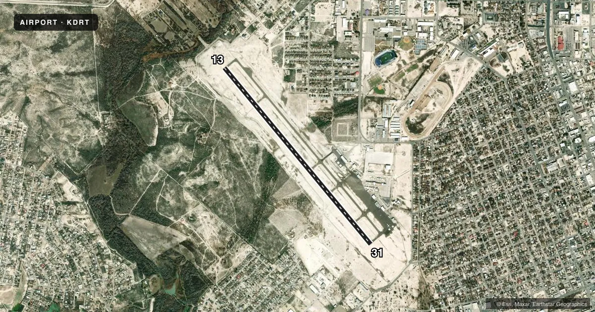
Airport sketch
Runways drawn to scale from FAA survey coordinates, rendered over satellite imagery. Not for navigation.
Approaches & charts
ILS · 1
Services on the field
Fuel grades, oxygen, maintenance, ramp storage and lighting — as declared to the FAA by the airport operator.
Fuel & services
- Fuel
- 100LLA+
- Airframe repair
- Major
- Power plant repair
- Major
- Other services
- CARGO,SALES
Ramp & ground
- Transient storage
- Tie-down
- Hangar
- Landing fee
- Yes
- Customs
- Available
- Lighting schedule
- SEE RMK
- Beacon schedule
- SS-SR
- Beacon
- White / Green (civil land)(WG)
- Wind indicator
- Lighted
- Segmented circle
- Yes
Fuel & FBOs
Cheapest 100LL and Jet A on the field and nearby. Always confirm with the FBO before taxi.
Airport notes
Surface conditions, obstructions, local procedures, lighting outages and other notes published with each FAA cycle.
General notes
- HELIPAD H1 & H2 LCTD SOUTH END OF MAIN PRKG RAMP.
- FOR CD CTC LAUGHLIN APCH AT 830-298-5192, WHEN APCH CLSD CTC HOUSTON ARTCC AT 281-230-5622.
- THE NATIONAL WEATHER SERVICE RELEASES WEATHER BALLOONS FROM THE DEL RIO AIRPORT TWICE DAILY (1200 AND 0000 ZULU).
- ARFF INDEX B AVAILABLE UPON REQUEST
Lighting notes
- ACTVT MALS RWY 13; REIL RWY 31; MIRL RWY 13/31; TWY - CTAF
Runway surface & condition
- 13/31PCR VALUE: 230/F/D/X/T
Approach & departure obstructions
- 1350:1 SLOPE TO THE DSPLCD THR.
Other notes
- STARTS AT 6,500 LBS MTOGW
- 2AFT HRS CALL 830-768-0898.
VFR map & nearby airports
VFR sectional. Tap any ICAO chip to open that airport.
Key facts · KDRT
Answer card- ICAO
- KDRT
- Name
- DEL RIO INTL
- Location
- DEL RIO, TEXAS
- Elevation
- 1,002.2 ft MSL
- Traffic pattern altitude
- 2,002.2 ft MSL (1,000 AGL)
- Control tower
- Non-towered (use CTAF)
- Total runways
- 1
- Longest runway
- 13/31 · 6,300 ft
- Published ILS approaches
- 1
- Published frequencies
- 6
- Magnetic variation
- 8°
- Current flight rules
- VFR
- Current wind
- 140° at 13 kt
- Favored runway now
- RWY 13
Del Rio Intl is in Del Rio, Texas. Field elevation is 1,002.2 ft MSL. The airport has one runway. Runway 13/31 is 6,300 ft of asphalt, which is the longest runway on the field. There is no control tower. CTAF and UNICOM are both 122.8. The published ILS is for runway 13. Runway 13 has MALSR lighting. Runway 31 has REIL lighting. Runway lighting on 13 and 31 is medium intensity. Taxiway lighting is controlled by CTAF.
Pattern altitude is not published. Use 1,000 ft AGL for light piston operations unless the current Chart Supplement or ATC gives you something different. The field sits near the border region with hot weather. Density altitude can matter in the summer. The published remarks also note a displaced threshold issue on runway 13 with a 50 to 1 slope to that threshold. That is worth checking before arrival. Pico Aviation is on the field. It carries 100LL and Jet A Prist. After hours, call the number listed in the Chart Supplement. Clearance delivery is handled through Laughlin Approach when it is open. When approach is closed, contact Houston ARTCC. The airport also publishes landing fees for aircraft above 6,500 pounds maximum takeoff gross weight. Check the current Chart Supplement for any local operating notes before you go.