METAR & TAF KJCT
Current METAR
Observed 18:51Z
KJCT 271851Z AUTO 14009G17KT 10SM CLR 34/22 A2998 RMK AO2 SLP111 T03390222
- Wind
- 140° @ 9G17 kt
- Visibility
- 10 SM
- Temp / Dew
- 34°C / 22°C
- Altimeter
- 29.98 inHg
- Clouds
- CLR
- Density alt
- 4,380 ft
- Ceiling
- Unlimited
- Rules
- VFR
Airport info & contacts
Manager on record, flight service, ARTCC, attendance schedule and pattern altitude — published by the FAA and refreshed every 28 days.
Location
- From city
- 1 NM NE
- VFR sectional
- SAN ANTONIO
- ARTCC
- ZHU · HOUSTON
- NOTAM facility
- JCT (NOTAM-D)
Airport manager
- Name
- DALLAS ANDRUS
- Phone
- 325-446-2820
- Address
- 635 AIRPORT ROAD, 501 MAIN, JUNCTION TX 76849
Flight service · Hours
- FSS SJT
- SAN ANGELO1-800-WX-BRIEF
- Attendance
- ALL
Frequencies
Tap any row to copy the frequency to your clipboard.
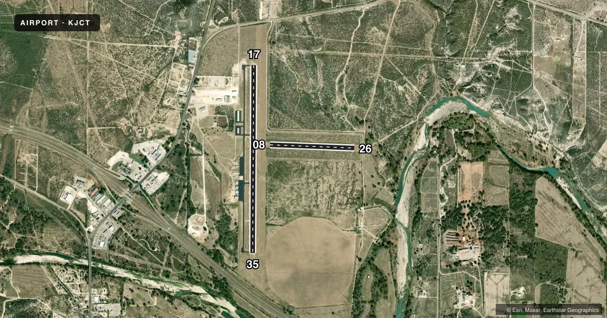
Runways & pattern
Full pagePattern entry · RWY 17
LEFT TRAFFIC| Runway | Heading (°M) | Length | Surface | Traffic |
|---|---|---|---|---|
| 17/35Favored | 172° / 352° | 5,004 ft | ASPH | Standard L |
| 08/26 | 84° / 264° | 2,255 ft | TURF | Standard L |
Runway end performance
| End | TORA | TODA | ASDA | LDA | VGSI | Approach lights | Obstruction |
|---|---|---|---|---|---|---|---|
| 17 | — | — | — | — | PAPI 4-box left(3.5°) | — | 200', hill, 4400' from thr, 0' R of cntrln, slope 21 |
| 35 | — | — | — | — | PAPI 4-box left(3°) | — | 45', trees, 1730' from thr, 0' R of cntrln, slope 34 |
| 26 | — | — | — | — | — | — | 34', trees, 500' from thr, 130' R of cntrln, slope 14 |
Declared distances in feet. TORA = takeoff run available, TODA = takeoff distance, ASDA = accelerate-stop, LDA = landing distance.
Airport sketch
Runways drawn to scale from FAA survey coordinates, rendered over satellite imagery. Not for navigation.
Approaches & charts
Services on the field
Fuel grades, oxygen, maintenance, ramp storage and lighting — as declared to the FAA by the airport operator.
Fuel & services
- Fuel
- 100LLA+
- Oxygen (bottled)
- Not available
- Oxygen (bulk)
- Not available
- Airframe repair
- Major
- Power plant repair
- Major
Ramp & ground
- Transient storage
- Tie-down
- Landing fee
- No fee published
- Customs
- Not available
- Lighting schedule
- SEE RMK
- Beacon schedule
- SS-SR
- Beacon
- White / Green (civil land)(WG)
- Wind indicator
- Lighted
- Segmented circle
- Yes
Fuel & FBOs
Cheapest 100LL and Jet A on the field and nearby. Always confirm with the FBO before taxi.
Airport notes
Surface conditions, obstructions, local procedures, lighting outages and other notes published with each FAA cycle.
General notes
- FQT MIL TRNG FLTS CONDUCTING LOW APCHS TO ARPT.
- FOR CD CTC HOUSTON ARTCC AT 281-230-5622.
Lighting notes
- DUSK-DAWN. MIRL RWY 17/35 PRESET LOW INTST; TO INCR INTST ACTVT - CTAF.
Approach & departure obstructions
- 08RWY 08 & RWY 26 THRS MKD WITH WHITE TIRES.
- 17UNUSBL BYD 5DEG LEFT OF CL.
VFR map & nearby airports
VFR sectional. Tap any ICAO chip to open that airport.
Key facts · KJCT
Answer card- ICAO
- KJCT
- Name
- KIMBLE COUNTY
- Location
- JUNCTION, TEXAS
- Elevation
- 1,753.6 ft MSL
- Traffic pattern altitude
- 2,753.6 ft MSL (1,000 AGL)
- Control tower
- Non-towered (use CTAF)
- Total runways
- 2
- Longest runway
- 17/35 · 5,004 ft
- Published ILS approaches
- 0
- Published frequencies
- 2
- Magnetic variation
- 8°
- Current flight rules
- VFR
- Current wind
- 140° at 9 kt
- Favored runway now
- RWY 17
Kimble County Airport sits in Junction, Texas. Field elevation is 1,753.6 ft MSL. The airport has two runways. The longest is 17/35 at 5,004 ft. Runway 08/26 is turf and 2,255 ft. This is an untowered field. CTAF and UNICOM are both 122.8. No ILS approaches are published.
Pattern altitude is not published. Use 1,000 ft AGL as the standard light-piston pattern reference unless local procedures or the current Chart Supplement say otherwise. The on-field FBO is Kimble County Airport. It carries 100LL and Jet A Prist. Call (325) 446-2820 for current service details before you go.
A few published remarks matter here. Runway 17 is unusable beyond 5 degrees left of centerline. Runway 17/35 lighting is set to low intensity from dusk to dawn. Use CTAF to increase the lights. Runway 08 and runway 26 thresholds are marked with white tires. Frequent military training flights also make low approaches to the airport. Keep a sharp scan on arrival and departure. For clearance delivery, contact Houston ARTCC at 281-230-5622. If you are planning a night arrival or a first trip into the field, review the current Chart Supplement and brief the runway alignment carefully.