METAR & TAF KBBD
Current METAR
Observed 13:15Z
KBBD 271315Z AUTO 18006KT 10SM CLR 24/21 A3000 RMK AO2
- Wind
- 180° @ 6 kt
- Visibility
- 10 SM
- Temp / Dew
- 24°C / 21°C
- Altimeter
- 30.00 inHg
- Clouds
- CLR
- Density alt
- 3,247 ft
- Ceiling
- Unlimited
- Rules
- VFR
Airport info & contacts
Manager on record, flight service, ARTCC, attendance schedule and pattern altitude — published by the FAA and refreshed every 28 days.
Location
- From city
- 3 NM NE
- VFR sectional
- SAN ANTONIO
- ARTCC
- ZHU · HOUSTON
- NOTAM facility
- SJT (NOTAM-D)
Airport manager
- Name
- SCOTT GRIFFIN
- Phone
- 325-597-1461
- Address
- 3825 N. BRIDGE ST, BRADY TX 76825
Flight service · Hours
- FSS SJT
- SAN ANGELO1-800-WX-BRIEF
- Attendance
- M-F · 0800-1700
- SAT-SUN · 0900-1300
Frequencies
Tap any row to copy the frequency to your clipboard.
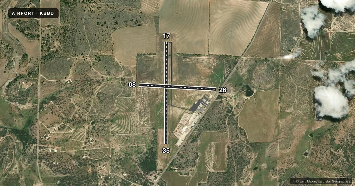
Runways & pattern
Full pagePattern entry · RWY 17
LEFT TRAFFIC| Runway | Heading (°M) | Length | Surface | Traffic |
|---|---|---|---|---|
| 17/35Favored | 173° / 353° | 4,605 ft | ASPH | Standard L |
| 08/26 | 86° / 266° | 3,520 ft | TURF | Standard L |
Runway end performance
| End | TORA | TODA | ASDA | LDA | VGSI | Approach lights | Obstruction |
|---|---|---|---|---|---|---|---|
| 17 | — | — | — | — | PAPI 2-box left(3°) | — | — |
| 35 | — | — | — | — | PAPI 2-box left(3°) | — | 36', trees, 930' from thr, 135' R of cntrln, slope 20 |
| 08 | — | — | — | — | — | — | 12', fence, 120' from thr, 0' R of cntrln, slope 10 |
| 26 | — | — | — | — | — | — | 12', fence, 182' from thr, 0' R of cntrln, slope 15 |
Declared distances in feet. TORA = takeoff run available, TODA = takeoff distance, ASDA = accelerate-stop, LDA = landing distance.
Airport sketch
Runways drawn to scale from FAA survey coordinates, rendered over satellite imagery. Not for navigation.
Approaches & charts
Services on the field
Fuel grades, oxygen, maintenance, ramp storage and lighting — as declared to the FAA by the airport operator.
Fuel & services
- Fuel
- 100LLA
- Oxygen (bottled)
- Not available
- Oxygen (bulk)
- Not available
- Airframe repair
- Major
- Power plant repair
- Major
Ramp & ground
- Transient storage
- Tie-down
- Hangar
- Landing fee
- No fee published
- Customs
- Not available
- Lighting schedule
- SEE RMK
- Beacon schedule
- SS-SR
- Beacon
- White / Green (civil land)(WG)
- Wind indicator
- Lighted
- Segmented circle
- Yes
Fuel & FBOs
Cheapest 100LL and Jet A on the field and nearby. Always confirm with the FBO before taxi.
Airport notes
Surface conditions, obstructions, local procedures, lighting outages and other notes published with each FAA cycle.
General notes
- DEER ON & INVOF ARPT.
- FOR CD CTC HOUSTON ARTCC AT 281-230-5622.
Lighting notes
- DUSK-DAWN. ACTVT MIRL RWY 17/35 - CTAF.
Runway surface & condition
- 08/26WEST 1240 FT CLSD, 2280 FT RMNG.
Other notes
- PRE-DATES THE ACT.
- MANAGERAMGR CELL 325-456-1595.
VFR map & nearby airports
VFR sectional. Tap any ICAO chip to open that airport.
Key facts · KBBD
Answer card- ICAO
- KBBD
- Name
- CURTIS FLD
- Location
- BRADY, TEXAS
- Elevation
- 1,827.4 ft MSL
- Traffic pattern altitude
- 2,827.4 ft MSL (1,000 AGL)
- Control tower
- Non-towered (use CTAF)
- Total runways
- 2
- Longest runway
- 17/35 · 4,605 ft
- Published ILS approaches
- 0
- Published frequencies
- 2
- Magnetic variation
- 7°
- Current flight rules
- VFR
- Current wind
- 180° at 6 kt
- Favored runway now
- RWY 17
Curtis Fld sits in Brady, Texas at 1,827.4 ft MSL. It has two runways. The longest is 17/35 at 4,605 ft asphalt. Runway 08/26 is turf at 3,520 ft. The west 1,240 ft is closed. That leaves 2,280 ft available. There is no control tower. CTAF and UNICOM are both 122.8. No ILS approaches are published.
Pattern altitude is not published. Use the standard 1,000 ft AGL for light piston operations unless the current Chart Supplement says otherwise. The field is in a high enough elevation band that performance planning matters on warm days. Deer are reported on and near the airport. Keep a sharp scan on taxi, takeoff and landing.
The on-field FBO is Brady Municipal Airport. It carries 100LL and Jet A Prist. For clearance delivery, Houston ARTCC is listed in the remarks. Runway 17/35 has medium intensity lights that you activate from CTAF from dusk to dawn. If you are new to the field, verify current airport details with the airport operator or the current FAA Chart Supplement before you go.