METAR & TAF KCOM
Current METAR
Observed 10:10Z
KCOM 271010Z AUTO 18005KT 10SM CLR 22/18 A3000 RMK AO2 T02220175 PWINO
- Wind
- 180° @ 5 kt
- Visibility
- 10 SM
- Temp / Dew
- 22°C / 18°C
- Altimeter
- 30.00 inHg
- Clouds
- CLR
- Density alt
- 2,845 ft
- Ceiling
- Unlimited
- Rules
- VFR
Airport info & contacts
Manager on record, flight service, ARTCC, attendance schedule and pattern altitude — published by the FAA and refreshed every 28 days.
Location
- From city
- 2 NM NE
- VFR sectional
- SAN ANTONIO
- ARTCC
- ZFW · FORT WORTH
- NOTAM facility
- FTW (NOTAM-D)
Airport manager
- Name
- RANDY LONG
- Phone
- 325-625-5495
- Address
- 503 AIRPORT LANE, COLEMAN TX 76834
Flight service · Hours
- FSS FTW
- FORT WORTH1-800-WX-BRIEF
- Attendance
- MON-FRI · 0800-1700
Frequencies
Tap any row to copy the frequency to your clipboard.
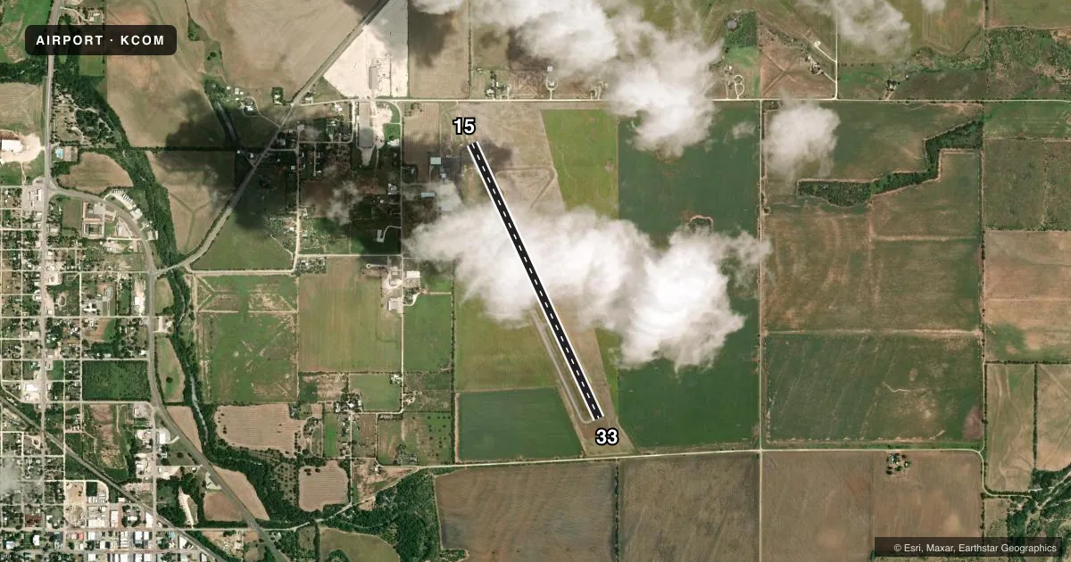
Runways & pattern
Full pagePattern entry · RWY 15
LEFT TRAFFICAirport sketch
Runways drawn to scale from FAA survey coordinates, rendered over satellite imagery. Not for navigation.
Approaches & charts
Services on the field
Fuel grades, oxygen, maintenance, ramp storage and lighting — as declared to the FAA by the airport operator.
Fuel & services
- Fuel
- 100LL
- Airframe repair
- Major
- Power plant repair
- Major
Ramp & ground
- Transient storage
- Tie-down
- Hangar
- Landing fee
- No fee published
- Customs
- Not available
- Lighting schedule
- SEE RMK
- Beacon schedule
- SS-SR
- Beacon
- White / Green (civil land)(WG)
- Wind indicator
- Lighted
- Segmented circle
- Yes
Fuel & FBOs
Cheapest 100LL and Jet A on the field and nearby. Always confirm with the FBO before taxi.
Airport notes
Surface conditions, obstructions, local procedures, lighting outages and other notes published with each FAA cycle.
General notes
- FOR CD CTC FORT WORTH ARTCC AT 817-858-7584.
Lighting notes
- RWY 15/33 MIRL PRESET TO LOW; TO INCR INTST AND ACTVT - CTAF.
Other notes
- 1EMPLOYEE LIVES ON PREMISES.
VFR map & nearby airports
VFR sectional. Tap any ICAO chip to open that airport.
Key facts · KCOM
Answer card- ICAO
- KCOM
- Name
- COLEMAN MUNI
- Location
- COLEMAN, TEXAS
- Elevation
- 1,696.8 ft MSL
- Traffic pattern altitude
- 2,696.8 ft MSL (1,000 AGL)
- Control tower
- Non-towered (use CTAF)
- Total runways
- 1
- Longest runway
- 15/33 · 4,506 ft
- Published ILS approaches
- 0
- Published frequencies
- 2
- Magnetic variation
- 7°
- Current flight rules
- VFR
- Current wind
- 180° at 5 kt
- Favored runway now
- RWY 15
Coleman Muni sits in Coleman, Texas. The field elevation is 1,696.8 ft MSL. It has one runway, 15/33, at 4,506 ft. There is no control tower. CTAF and UNICOM are both 122.8. No ILS approaches are published here.
The pattern altitude is not published. Use the standard 1,000 ft AGL pattern unless the current Chart Supplement says otherwise. That puts the light piston pattern at about 2,696.8 ft MSL based on the field elevation. Runway 15/33 has medium intensity lights preset to low. Use the CTAF to increase intensity and activate the lighting.
Coleman Municipal Airport is the on-field FBO. It carries AVGAS 100LL. Call (325) 625-2293 before you go if you need current ramp or fuel details. The published remarks also say an employee lives on the premises. For clearance delivery, contact Fort Worth ARTCC at 817-858-7584. This is a non-towered field at moderate elevation. Plan for density altitude effects on warm days. Verify the latest procedures before departure or arrival.