METAR & TAF KGZN
Current METAR
Observed 15:15Z
KGZN 271515Z AUTO 19011KT 10SM CLR 30/22 A2999 RMK AO2
- Wind
- 190° @ 11 kt
- Visibility
- 10 SM
- Temp / Dew
- 30°C / 22°C
- Altimeter
- 29.99 inHg
- Clouds
- CLR
- Density alt
- 3,835 ft
- Ceiling
- Unlimited
- Rules
- VFR
Airport info & contacts
Manager on record, flight service, ARTCC, attendance schedule and pattern altitude — published by the FAA and refreshed every 28 days.
Location
- From city
- 3 NM WSW
- VFR sectional
- DALLAS-FT WORTH
- ARTCC
- ZFW · FORT WORTH
- NOTAM facility
- FTW (NOTAM-D)
Airport manager
- Name
- SCOT PENN
- Phone
- 254-433-1874
- Address
- 215 COUNTY 129, CISCO TX 76437
Flight service · Hours
- FSS FTW
- FORT WORTH1-800-WX-BRIEF
- Attendance
- MON-FRI · 0800-1700
Frequencies
Tap any row to copy the frequency to your clipboard.
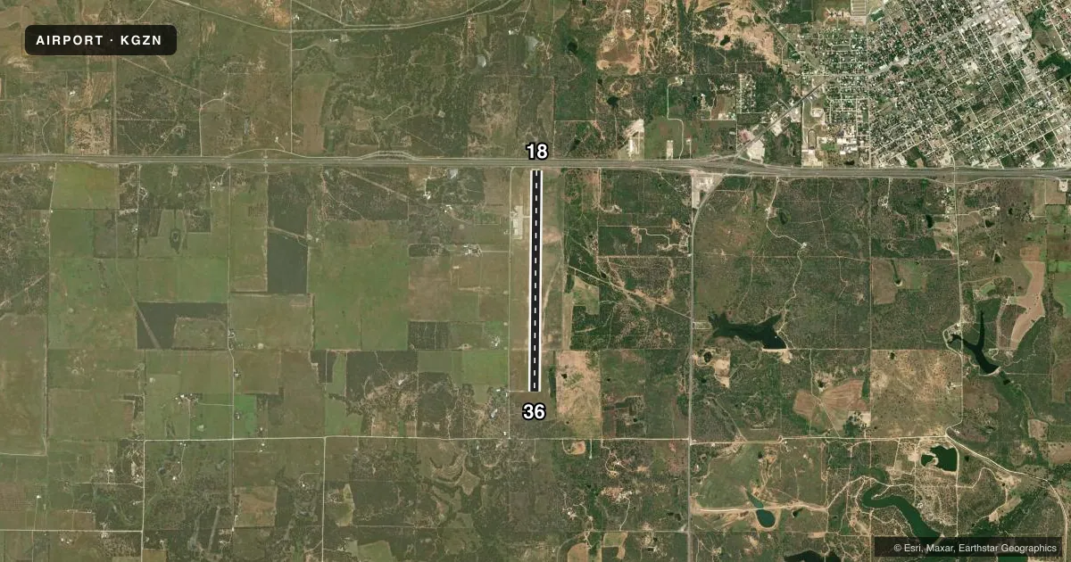
Runways & pattern
Full pagePattern entry · RWY 18
RIGHT TRAFFICRunway end performance
| End | TORA | TODA | ASDA | LDA | VGSI | Approach lights | Obstruction |
|---|---|---|---|---|---|---|---|
| 18 | 6,536' | 6,536' | 6,064' | 6,064' | PAPI 4-box left(3°) | — | 17', road, 200' from thr, 0' R of cntrln, slope 0 |
| 36 | 6,536' | 6,536' | 6,536' | 6,536' | PAPI 4-box left(3.2°) | — | 33', pole, 566' from thr, 59' R of cntrln, slope 11 |
Declared distances in feet. TORA = takeoff run available, TODA = takeoff distance, ASDA = accelerate-stop, LDA = landing distance.
Airport sketch
Runways drawn to scale from FAA survey coordinates, rendered over satellite imagery. Not for navigation.
Approaches & charts
Services on the field
Fuel grades, oxygen, maintenance, ramp storage and lighting — as declared to the FAA by the airport operator.
Fuel & services
- Fuel
- 100LLA
- Contract fuel
- Available
- Airframe repair
- Minor
- Power plant repair
- Minor
Ramp & ground
- Transient storage
- Tie-down
- Hangar
- Lighting schedule
- SEE RMK
- Wind indicator
- Lighted
- Segmented circle
- Yes
Fuel & FBOs
Cheapest 100LL and Jet A on the field and nearby. Always confirm with the FBO before taxi.
Airport notes
Surface conditions, obstructions, local procedures, lighting outages and other notes published with each FAA cycle.
General notes
- FOR CD CTC FORT WORTH ARTCC AT 817-858-7584.
- 260 FT AGL LGTD/MKD TWR 0.74 SM E OF RWY.
- 330 FT AGL LGTD/MKD TWR 0.42 NM SE OF RWY.
Lighting notes
- ACTVT PAPI RWY 18 & 36; MIRL RWY 18/36 - CTAF.
Fuel notes
- 100LLFUEL 24 HR SELF SERVE.
Approach & departure obstructions
- 188 FT BLAST WALL 38 FT FM RWY END, BOTH SIDES OF CNTRLN; 8 FT FENCE 38 FT DSTC ACRS APCH.
- 3611 FT PUMP JACK AT THR, 213 FT LEFT; 17 FT LIT POLE AT THR, 213 FT LEFT.
- 18APCH RATIO 51:1 TO DSPLCD THR OVR 28 FT POLE, 888 FT DSTC, 235 FT L.
Other notes
- 1NO LONGER OFFERING AFT HRS CALL-OUT SVCS.
- MANAGERSPENN@WILKSBROTHERS.COM ALT NO: 254-433-2071
VFR map & nearby airports
VFR sectional. Tap any ICAO chip to open that airport.
Key facts · KGZN
Answer card- ICAO
- KGZN
- Name
- GREGORY M SIMMONS MEML
- Location
- CISCO, TEXAS
- Elevation
- 1,711.1 ft MSL
- Traffic pattern altitude
- 2,711.1 ft MSL (1,000 AGL)
- Control tower
- Non-towered (use CTAF)
- Total runways
- 1
- Longest runway
- 18/36 · 6,536 ft
- Published ILS approaches
- 0
- Published frequencies
- 3
- Magnetic variation
- 4°
- Current flight rules
- VFR
- Current wind
- 190° at 11 kt
- Favored runway now
- RWY 18
Gregory M Simmons Meml Airport sits in Cisco, Texas. The field elevation is 1,711.1 ft MSL. It has one runway, 18/36, which is 6,536 ft long and paved concrete. There is no control tower. CTAF is 122.9. Approach and departure service is handled through Abilene on 125.0 and 338.3. No ILS approaches are published here.
Pattern altitude is not published. Use the standard 1,000 ft AGL pattern unless local procedures or the current Chart Supplement say otherwise. Cisco Aviation is on the field. It carries 100LL and Jet A. 100LL is available 24 hours self-serve. The airport remarks also say after-hours call-out service is no longer offered. Plan fuel and ground support before you arrive.
This is a high-elevation field, so expect density altitude to matter on warm days. There are lighted and marked towers near the runway environment. One is 0.74 SM east of the runway. Another is 0.42 NM southeast. There are also obstructions near both thresholds, including a blast wall, fence, pump jack and lighted pole. PAPI and medium intensity runway lights for 18 and 36 are activated on the CTAF. If you need clearance delivery, contact Fort Worth ARTCC. For anything current on operations, check the FAA Chart Supplement or call the airport operator directly.