METAR & TAF T23
T23 does not publish a METAR.
Showing the nearest reporting station: KBKD (STEPHENS COUNTY) · 19.0 NM away. Conditions at T23 may differ.
METAR · KBKD
Observed 15:15Z
KBKD 271515Z AUTO 20008G15KT 5SM CLR 32/21 A2998 RMK AO2 T03150209
- Wind
- 200° @ 8G15 kt
- Visibility
- 5 SM
- Temp / Dew
- 32°C / 21°C
- Altimeter
- 29.98 inHg
- Clouds
- CLR
- Density alt
- 3,720 ft
- Ceiling
- Unlimited
- Rules
- MVFR
Airport info & contacts
Manager on record, flight service, ARTCC, attendance schedule and pattern altitude — published by the FAA and refreshed every 28 days.
Location
- From city
- 2 NM E
- VFR sectional
- DALLAS-FT WORTH
- ARTCC
- ZFW · FORT WORTH
- NOTAM facility
- FTW (NOTAM-D)
Airport manager
- Name
- BILLY HOLSON
- Phone
- 325-762-0383
- Address
- 425 S SECOND ST, P O BOX 3248, ALBANY TX 76430
Flight service · Hours
- FSS FTW
- FORT WORTH1-800-WX-BRIEF
- Attendance
- IREG
Frequencies
Tap any row to copy the frequency to your clipboard.
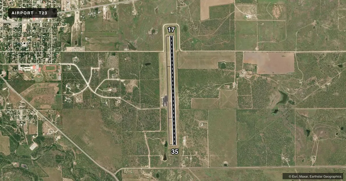
Runways & pattern
Full pagePattern entry · RWY 17
LEFT TRAFFICRunway end performance
| End | TORA | TODA | ASDA | LDA | VGSI | Approach lights | Obstruction |
|---|---|---|---|---|---|---|---|
| 17 | — | — | — | — | PAPI 2-box left(3°) | — | 8', road, 500' from thr, 0' R of cntrln, slope 37 |
| 35 | — | — | — | — | PAPI 2-box left(3°) | — | 10', trees, 512' from thr, 160' R of cntrln, slope 31 |
Declared distances in feet. TORA = takeoff run available, TODA = takeoff distance, ASDA = accelerate-stop, LDA = landing distance.
Airport sketch
Runways drawn to scale from FAA survey coordinates, rendered over satellite imagery. Not for navigation.
Approaches & charts
Services on the field
Fuel grades, oxygen, maintenance, ramp storage and lighting — as declared to the FAA by the airport operator.
Fuel & services
- Fuel
- 100LLA
Ramp & ground
- Transient storage
- Tie-down
- Landing fee
- No fee published
- Lighting schedule
- SEE RMK
- Beacon schedule
- SS-SR
- Beacon
- White / Green (civil land)(WG)
- Wind indicator
- Lighted
- Segmented circle
- Yes
Fuel & FBOs
Cheapest 100LL and Jet A on the field and nearby. Always confirm with the FBO before taxi.
Airport notes
Surface conditions, obstructions, local procedures, lighting outages and other notes published with each FAA cycle.
General notes
- FOR CD CTC FORT WORTH ARTCC AT 817-858-7584.
Lighting notes
- MIRL RWY 17/35 PRESET LOW INTST; TO INCR INTST AND ACTVT PAPI RWY 17 & 35 - 123.5.
Fuel notes
- 100LL100LL AND JET A 24 HRS SELF SERVE.
Approach & departure obstructions
- 17ALSO, 25 FT MKD PLINE, 990 FT DSTC, 0 FT B, APCH SLOPE 31:1.
Other notes
- PRVDD APCHS ARE MAINTD FOR A 20:1 SLOPE.
- MANAGERCITY/AIRPORT MGR.
VFR map & nearby airports
VFR sectional. Tap any ICAO chip to open that airport.
Key facts · T23
Answer card- ICAO
- T23
- Name
- ALBANY MUNI
- Location
- ALBANY, TEXAS
- Elevation
- 1,414.8 ft MSL
- Traffic pattern altitude
- 2,414.8 ft MSL (1,000 AGL)
- Control tower
- Non-towered (use CTAF)
- Total runways
- 1
- Longest runway
- 17/35 · 5,000 ft
- Published ILS approaches
- 0
- Published frequencies
- 3
- Magnetic variation
- 5°
- Current flight rules
- MVFR
- Current wind
- 200° at 8 kt
- Favored runway now
- RWY 17
Albany Muni sits in Albany, Texas. The field elevation is 1,414.8 ft MSL. It has one runway. Runway 17/35 is 5,000 ft long and asphalt. There is no control tower. CTAF is 122.9. Approach and departure service is listed with Abilene on 125.0 and 338.3.
No ILS approaches are published here. The pattern altitude is not published. Use the standard 1,000 ft AGL pattern for light piston aircraft unless the current Chart Supplement says otherwise. The published remarks call out medium intensity runway lights on 17/35. They are preset to low intensity. Use 123.5 to increase intensity and to activate the PAPI on runways 17 and 35. There is also a marked power line near the runway 17 end. It sits 990 ft from the threshold, 25 ft high and 0 ft right of centerline. That makes the 17 side worth a careful look on short final.
There are no on-field FBOs listed. 100LL and Jet A are available 24 hours self serve. For clearance delivery, contact Fort Worth ARTCC at 817-858-7584. First-time arrivals should plan for an uncontrolled field. Watch the runway 17 obstacle note. Verify any local procedures with the current Chart Supplement before flying in.