METAR & TAF F56
F56 does not publish a METAR.
Showing the nearest reporting station: KABI (ABILENE RGNL) · 30.1 NM away. Conditions at F56 may differ.
METAR · KABI
Observed 14:52Z
KABI 271452Z 20012KT 10SM CLR 29/21 A3000 RMK AO2 SLP127 T02940211 51004
- Wind
- 200° @ 12 kt
- Visibility
- 10 SM
- Temp / Dew
- 29°C / 21°C
- Altimeter
- 30.00 inHg
- Clouds
- CLR
- Density alt
- 3,516 ft
- Ceiling
- Unlimited
- Rules
- VFR
Airport info & contacts
Manager on record, flight service, ARTCC, attendance schedule and pattern altitude — published by the FAA and refreshed every 28 days.
Location
- From city
- 4 NM SE
- VFR sectional
- DALLAS-FT WORTH
- ARTCC
- ZFW · FORT WORTH
- NOTAM facility
- FTW (NOTAM-D)
Airport manager
- Name
- ALAN PLUMLEE
- Phone
- 325-773-2591
- Address
- 201 E. MC HARG, PO BOX 191, STAMFORD TX 79553
Flight service · Hours
- FSS FTW
- FORT WORTH1-800-WX-BRIEF
- Attendance
- Unattended
Frequencies
Tap any row to copy the frequency to your clipboard.
Runways & pattern
Full pagePattern entry · RWY 17
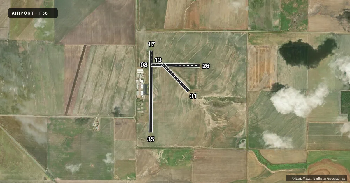
LEFT TRAFFIC| Runway | Heading (°M) | Length | Surface | Traffic |
|---|---|---|---|---|
| 17/35Favored | 174° / 354° | 3,707 ft | ASPH | Standard L |
| 08/26 | 85° / 265° | 2,211 ft | TURF | Standard L |
| 13/31 | 130° / 310° | 1,702 ft | TURF-GRVL | Standard L |
Runway end performance
| End | TORA | TODA | ASDA | LDA | VGSI | Approach lights | Obstruction |
|---|---|---|---|---|---|---|---|
| 17 | — | — | — | — | — | — | 15', road, 860' from thr, 0' R of cntrln, slope 44 |
| 13 | — | — | — | — | — | — | 10', road, 0' from thr, 0' R of cntrln, slope 0 |
| 31 | — | — | — | — | — | — | 10', road, 0' from thr, 0' R of cntrln, slope 0 |
Declared distances in feet. TORA = takeoff run available, TODA = takeoff distance, ASDA = accelerate-stop, LDA = landing distance.
Airport sketch
Runways drawn to scale from FAA survey coordinates, rendered over satellite imagery. Not for navigation.
Approaches & charts
Services on the field
Fuel grades, oxygen, maintenance, ramp storage and lighting — as declared to the FAA by the airport operator.
Fuel & services
- Fuel
- 100LL
- Oxygen (bottled)
- Not available
- Oxygen (bulk)
- Not available
- Airframe repair
- Major
- Power plant repair
- Major
- Other services
- AGRI
Ramp & ground
- Transient storage
- Tie-down
- Hangar
- Landing fee
- No fee published
- Customs
- Not available
- Lighting schedule
- SEE RMK
- Beacon schedule
- SS-SR
- Beacon
- White / Green (civil land)(WG)
- Wind indicator
- Lighted
- Segmented circle
- Yes
Fuel & FBOs
Cheapest 100LL and Jet A on the field and nearby. Always confirm with the FBO before taxi.
Airport notes
Surface conditions, obstructions, local procedures, lighting outages and other notes published with each FAA cycle.
General notes
- FARM EQUIPMENT INVOF AIRPORT.
- FOR CD CTC FORT WORTH ARTCC AT 817-858-7584.
Lighting notes
- ACTVT MIRL RWY 17/35 - CTAF.
Approach & departure obstructions
- 1710 FT ROAD 60 FT EAST OF RWY CNTRLN AT THR.
Other notes
- MANAGERCITY MANAGER
- 08/26RWY SFC ROUGH.
- 13/31RWY SFC ROUGH.
VFR map & nearby airports
VFR sectional. Tap any ICAO chip to open that airport.
Key facts · F56
Answer card- ICAO
- F56
- Name
- ARLEDGE FLD
- Location
- STAMFORD, TEXAS
- Elevation
- 1,560.8 ft MSL
- Traffic pattern altitude
- 2,560.8 ft MSL (1,000 AGL)
- Control tower
- Non-towered (use CTAF)
- Total runways
- 3
- Longest runway
- 17/35 · 3,707 ft
- Published ILS approaches
- 0
- Published frequencies
- 4
- Magnetic variation
- 6°
- Current flight rules
- VFR
- Current wind
- 200° at 12 kt
- Favored runway now
- RWY 17
Arledge Field sits in Stamford, Texas. Field elevation is 1,560.8 ft MSL. The airport has three runways. The longest is 17/35 at 3,707 ft. This is an untowered field. CTAF and UNICOM are both 122.8. No ILS approaches are published here.
The published pattern altitude is not listed, so use the standard 1,000 ft AGL for light piston traffic unless the current FAA Chart Supplement says otherwise. That puts the pattern at about 2,561 ft MSL based on the field elevation. Runway 17/35 has medium intensity lighting that is activated on CTAF. The on-field FBO is Arledge Field. It carries 100LL. Call them at (325) 370-7986 before arrival if you need current service details.
Two runways are turf. Runway 08/26 is 2,211 ft. The surface is reported rough. Runway 13/31 is 1,702 ft. The surface is also reported rough. There is a 10-foot road about 60 feet east of the runway centerline near the threshold of runway 17. Farm equipment has also been reported in the vicinity. Clearance delivery goes through Fort Worth ARTCC at 817-858-7584. For a first visit, plan for a small-field environment. Watch the rough turf. Brief the lighting and obstruction near runway 17 before you go.