METAR & TAF 15F
15F does not publish a METAR.
Showing the nearest reporting station: KABI (ABILENE RGNL) · 46.9 NM away. Conditions at 15F may differ.
METAR · KABI
Observed 12:52Z
KABI 271252Z 18008KT 10SM CLR 25/21 A2999 RMK AO2 SLP123 T02500206
- Wind
- 180° @ 8 kt
- Visibility
- 10 SM
- Temp / Dew
- 25°C / 21°C
- Altimeter
- 29.99 inHg
- Clouds
- CLR
- Density alt
- 3,129 ft
- Ceiling
- Unlimited
- Rules
- VFR
Airport info & contacts
Manager on record, flight service, ARTCC, attendance schedule and pattern altitude — published by the FAA and refreshed every 28 days.
Location
- From city
- 2 NM N
- VFR sectional
- DALLAS-FT WORTH
- ARTCC
- ZFW · FORT WORTH
- NOTAM facility
- FTW (NOTAM-D)
Airport manager
- Name
- MATT USSERY
- Phone
- 940-864-2333
- Address
- 301 SOUTH 1ST STRET, HASKELL TX 79521
Flight service · Hours
- FSS FTW
- FORT WORTH1-800-WX-BRIEF
- Attendance
- Unattended
Frequencies
Tap any row to copy the frequency to your clipboard.
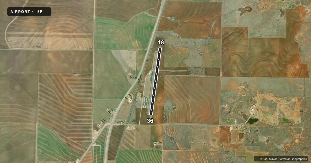
Runways & pattern
Full pagePattern entry · RWY 18
LEFT TRAFFICRunway end performance
| End | TORA | TODA | ASDA | LDA | VGSI | Approach lights | Obstruction |
|---|---|---|---|---|---|---|---|
| 18 | — | — | — | — | — | — | 35', pline, 600' from thr, 325' R of cntrln, slope 11 |
| 36 | — | — | — | — | — | — | 15', road, 416' from thr, 0' R of cntrln, slope 14 |
Declared distances in feet. TORA = takeoff run available, TODA = takeoff distance, ASDA = accelerate-stop, LDA = landing distance.
Airport sketch
Runways drawn to scale from FAA survey coordinates, rendered over satellite imagery. Not for navigation.
Approaches & charts
Services on the field
Fuel grades, oxygen, maintenance, ramp storage and lighting — as declared to the FAA by the airport operator.
Fuel & services
- Fuel
- 100LL
- Oxygen (bottled)
- Not available
- Oxygen (bulk)
- Not available
- Other services
- AGRI
Ramp & ground
- Transient storage
- Tie-down
- Hangar
- Landing fee
- No fee published
- Customs
- Not available
- Lighting schedule
- SEE RMK
- Beacon schedule
- SS-SR
- Beacon
- White / Green (civil land)(WG)
- Wind indicator
- Lighted
- Segmented circle
- Yes
Fuel & FBOs
Cheapest 100LL and Jet A on the field and nearby. Always confirm with the FBO before taxi.
Airport notes
Surface conditions, obstructions, local procedures, lighting outages and other notes published with each FAA cycle.
General notes
- NO LINE OF SIGHT BETWEEN RY ENDS.
- FOR CD CTC FORT WORTH ARTCC AT 817-858-7584.
Lighting notes
- ACTVT MIRL RWY 18/36 - 122.8. NMRS LTS OUT, OBSCURED BY VEGETATION.
Fuel notes
- 100LLFOR FUEL WKDAYS 0800-1700 CALL 940-207-1855; NIGHTS & WKENDS CALL 940-864-2345.
Approach & departure obstructions
- 364 FT PIPE 174 FT DSTC, 49 FT. L
- 18MKG POOR.
- 36MKG POOR.
- 18APCH SLOPE 17:1 TO DSPLCD THLD.
Other notes
- THIS AIRPORT HAS BEEN SURVEYED BY THE NATIONAL GEODETIC SURVEY.
- MANAGERPUBLIC WORKS DIRECTOR.
- 18/36NMRS CRACKS, SPALLING, LOOSE STONES, VEGETATION GROWING.
VFR map & nearby airports
VFR sectional. Tap any ICAO chip to open that airport.
Key facts · 15F
Answer card- ICAO
- 15F
- Name
- HASKELL MUNI
- Location
- HASKELL, TEXAS
- Elevation
- 1,625.4 ft MSL
- Traffic pattern altitude
- 2,625.4 ft MSL (1,000 AGL)
- Control tower
- Non-towered (use CTAF)
- Total runways
- 1
- Longest runway
- 18/36 · 3,420 ft
- Published ILS approaches
- 0
- Published frequencies
- 1
- Magnetic variation
- 5°
- Current flight rules
- VFR
- Current wind
- 180° at 8 kt
- Favored runway now
- RWY 18
Haskell Muni Airport (15F) sits in Haskell, Texas. Field elevation is 1,625.4 ft MSL. The airport has one runway. Runway 18/36 is 3,420 ft long and asphalt. There is no control tower. CTAF is 122.9. No ILS approaches are published here.
Pattern altitude is not published. Use the standard 1,000 ft AGL pattern unless local procedures or current chart data say otherwise. The field is in a rural area, so plan for a non-towered arrival and keep your scan sharp on the traffic pattern. Published remarks say there is no line of sight between the runway ends. That matters on the ground and in the pattern. Runway 18 has poor markings. Runway 36 also has poor markings. The runway has numerous cracks, spalling, loose stones and vegetation growing. There is also a 4-foot pipe near runway 36, 174 ft out and 49 ft left of centerline.
Haskell Municipal Airport is the on-field FBO. It carries AVGAS 100LL. For fuel service, the published remarks give weekday and after-hours phone numbers. The runway lights are medium intensity and are activated on 122.8. Several lights are out or hidden by vegetation. For clearance delivery, contact Fort Worth ARTCC. If you need current operational details, check the current FAA Chart Supplement or call the airport operator directly before you go.