METAR & TAF KONY
KONY does not publish a METAR.
Showing the nearest reporting station: KRPH (GRAHAM MUNI) · 19.6 NM away. Conditions at KONY may differ.
METAR · KRPH
Observed 16:15Z
KRPH 271615Z AUTO VRB06KT 10SM CLR 33/22 A2994 RMK AO2 T03260216 $
- Wind
- VAR @ 6 kt
- Visibility
- 10 SM
- Temp / Dew
- 33°C / 22°C
- Altimeter
- 29.94 inHg
- Clouds
- CLR
- Density alt
- 3,717 ft
- Ceiling
- Unlimited
- Rules
- VFR
Airport info & contacts
Manager on record, flight service, ARTCC, attendance schedule and pattern altitude — published by the FAA and refreshed every 28 days.
Location
- From city
- 3 NM SW
- VFR sectional
- DALLAS-FT WORTH
- ARTCC
- ZFW · FORT WORTH
- NOTAM facility
- FTW (NOTAM-D)
Airport manager
- Name
- JIM HIRSCH
- Phone
- 940-564-5616
- Address
- PO BOX 485, 1524 LELAND SNOW WAY, OLNEY TX 76374
Flight service · Hours
- FSS FTW
- FORT WORTH1-800-WX-BRIEF
- Attendance
- M-F · 0800-1700
Frequencies
Tap any row to copy the frequency to your clipboard.
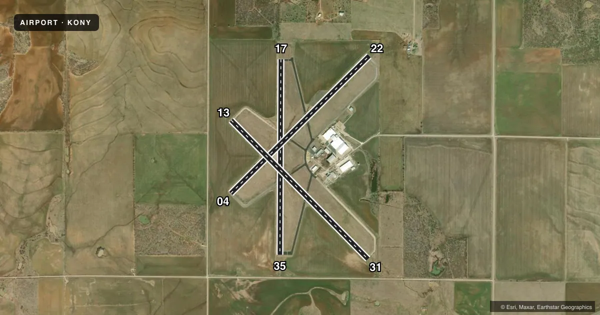
Runways & pattern
Full pagePattern entry · RWY 35
LEFT TRAFFIC| Runway | Heading (°M) | Length | Surface | Traffic |
|---|---|---|---|---|
| 17/35Favored | 175° / 355° | 5,101 ft | ASPH | Standard L |
| 04/22 | 40° / 220° | 5,100 ft | ASPH | Standard L |
| 13/31 | 130° / 310° | 5,099 ft | ASPH | Standard L |
Runway end performance
| End | TORA | TODA | ASDA | LDA | VGSI | Approach lights | Obstruction |
|---|---|---|---|---|---|---|---|
| 17 | — | — | — | — | VASI 2-box left(3°) | — | 22', trees, 574' from thr, 19' R of cntrln, slope 17 |
| 35 | — | — | — | — | VASI 2-box right(3°) | — | 15', road, 575' from thr, 0' R of cntrln, slope 25 |
| 04 | — | — | — | — | — | — | 16', trees, 746' from thr, 250' R of cntrln, slope 34 |
| 22 | — | — | — | — | — | — | 50', pline, 2125' from thr, 0' R of cntrln, slope 38 |
| 13 | — | — | — | — | — | — | 15', road, 700' from thr, 175' R of cntrln, slope 33 |
| 31 | — | — | — | — | — | — | 15', road, 410' from thr, 250' R of cntrln, slope 14 |
Declared distances in feet. TORA = takeoff run available, TODA = takeoff distance, ASDA = accelerate-stop, LDA = landing distance.
Airport sketch
Runways drawn to scale from FAA survey coordinates, rendered over satellite imagery. Not for navigation.
Approaches & charts
Services on the field
Fuel grades, oxygen, maintenance, ramp storage and lighting — as declared to the FAA by the airport operator.
Fuel & services
- Fuel
- 100LL
- Oxygen (bottled)
- Not available
- Oxygen (bulk)
- Not available
- Airframe repair
- Not available
- Power plant repair
- Not available
- Other services
- AGRI
Ramp & ground
- Transient storage
- Tie-down
- Landing fee
- No fee published
- Customs
- Not available
- Lighting schedule
- SEE RMK
- Beacon schedule
- SS-SR
- Beacon
- White / Green (civil land)(WG)
- Wind indicator
- Yes
- Segmented circle
- Yes
Fuel & FBOs
Cheapest 100LL and Jet A on the field and nearby. Always confirm with the FBO before taxi.
Airport notes
Surface conditions, obstructions, local procedures, lighting outages and other notes published with each FAA cycle.
General notes
- OCNL AERIAL AG OPNS
- RWY 13/31 CNTR 1600 FT BY 75 FT OVERLAID WITH NO GRASS ENCROACHMENT.
- FOR CD CTC FORT WORTH ARTCC AT 817-858-7584.
Lighting notes
- MIRL RWY 17/35 PRESET TO LOW INTST, TO INCR INTST ACTV - CTAF.
Fuel notes
- 100LLSELF SVC FUEL AVBL.
Other notes
- PRE-DATES ACT.
- MANAGER940-250-9121 AMGR CELL.
- 13/31FIRST THIRD AND LAST THIRD OF RWY EXTSV CRACKS W/VEGETATION GROWING THROUGH. LOOSE STONES.
VFR map & nearby airports
VFR sectional. Tap any ICAO chip to open that airport.
Key facts · KONY
Answer card- ICAO
- KONY
- Name
- OLNEY MUNI
- Location
- OLNEY, TEXAS
- Elevation
- 1,275.4 ft MSL
- Traffic pattern altitude
- 2,275.4 ft MSL (1,000 AGL)
- Control tower
- Non-towered (use CTAF)
- Total runways
- 3
- Longest runway
- 17/35 · 5,101 ft
- Published ILS approaches
- 0
- Published frequencies
- 2
- Magnetic variation
- 5°
- Current flight rules
- VFR
- Current wind
- 000° at 6 kt
- Favored runway now
- RWY 35
Olney Muni is in Olney, Texas. The field elevation is 1,275.4 ft MSL. It has three asphalt runways. The longest is 5,101 ft on runway 17/35. There is no control tower. CTAF and UNICOM are both 122.8. No ILS approaches are published.
The pattern altitude is not published. Use the standard 1,000 ft AGL pattern for light piston traffic unless the current Chart Supplement says otherwise. The on-field FBO is Olney Municipal Airport. It carries 100LL. Self-serve fuel is available. The published remarks also note that runway 13/31 has a center section overlaid, but the first third and last third have extensive cracking with vegetation and loose stones. That runway deserves a close look on rollout and takeoff.
One other item to plan for is occasional aerial agricultural operations. Runway 17/35 has medium intensity lights that come up at low intensity by default. Use CTAF to increase intensity. The airport predates the tower era, so expect non-towered procedures and keep your scan tight. For clearance delivery, Fort Worth ARTCC is listed in the remarks. Check current procedures before you go.