METAR & TAF 21F
21F does not publish a METAR.
Showing the nearest reporting station: KXBP (BRIDGEPORT MUNI) · 16.3 NM away. Conditions at 21F may differ.
METAR · KXBP
Observed 05:30Z
KXBP 270530Z AUTO 19008KT CLR 29/17 A2996 RMK AO2 T02870170 PWINO
- Wind
- 190° @ 8 kt
- Visibility
- —
- Temp / Dew
- 29°C / 17°C
- Altimeter
- 29.96 inHg
- Clouds
- CLR
- Density alt
- 2,947 ft
- Ceiling
- Unlimited
- Rules
- VFR
Airport info & contacts
Manager on record, flight service, ARTCC, attendance schedule and pattern altitude — published by the FAA and refreshed every 28 days.
Location
- From city
- 1 NM NE
- VFR sectional
- DALLAS-FT WORTH
- ARTCC
- ZFW · FORT WORTH
- NOTAM facility
- FTW (NOTAM-D)
Airport manager
- Name
- JESSE MAXWELL
- Phone
- 940-507-3147
- Address
- 112 WEST BELKNAP, JACKSBORO TX 76458
Flight service · Hours
- FSS FTW
- FORT WORTH1-800-WX-BRIEF
- Attendance
- UNATND
Frequencies
Tap any row to copy the frequency to your clipboard.
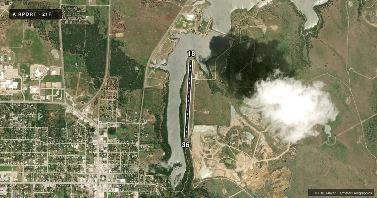
Runways & pattern
Full pagePattern entry · RWY 18
LEFT TRAFFICRunway end performance
| End | TORA | TODA | ASDA | LDA | VGSI | Approach lights | Obstruction |
|---|---|---|---|---|---|---|---|
| 18 | — | — | — | — | — | — | 67', pole, 1500' from thr, 0' R of cntrln, slope 19 |
| 36 | — | — | — | — | — | — | 20', trees, 201' from thr, 30' R of cntrln, slope 0 |
Declared distances in feet. TORA = takeoff run available, TODA = takeoff distance, ASDA = accelerate-stop, LDA = landing distance.
Airport sketch
Runways drawn to scale from FAA survey coordinates, rendered over satellite imagery. Not for navigation.
Approaches & charts
Services on the field
Fuel grades, oxygen, maintenance, ramp storage and lighting — as declared to the FAA by the airport operator.
Fuel & services
- Fuel
- 100LL
- Oxygen (bottled)
- Not available
- Oxygen (bulk)
- Not available
Ramp & ground
- Transient storage
- Tie-down
- Landing fee
- No fee published
- Customs
- Not available
- Lighting schedule
- SS-SR
- Beacon schedule
- SS-SR
- Beacon
- White / Green (civil land)(WG)
- Wind indicator
- Lighted
- Segmented circle
- Yes
Fuel & FBOs
Cheapest 100LL and Jet A on the field and nearby. Always confirm with the FBO before taxi.
Airport notes
Surface conditions, obstructions, local procedures, lighting outages and other notes published with each FAA cycle.
General notes
- ARPT GATE LOCKED-COMBINATION 1581.
- BIRDS ON AND INVOF ARPT.
- COURTESY CAR AVBL. NEXT TO FUEL PUMP, KEYBOX ON NW POLE, CODE 1581. CALL 940-507-3147 TO RES OR USE CAR.
- 6 FT OPEN DRAINAGE DITCH NEAR RWY 18 THR, 81 FT EAST OF CNTRLN ON BOTH SIDES OF TWY.
- 5 FT OPEN DRAINAGE DITCH 84 FT EAST OF RWY 18 CNTRLN ON BOTH SIDES OF RAMP SOUTH TWY.
- PILOT LOUNGE/RESTROOM ACCESS 1200.
Approach & departure obstructions
- 1810 FT TREES, 20-199 FT DSTC, 115 L.
- 3615 FT TREES, 0-199 FT DSTC.
- 18CONTROLLING OBSTRUCTION EXCEEDS A 45 DEGREE SLOPE
Other notes
- MANAGERPARKS DIR/AMGR.
- MANAGERFOR AFTR HRS ASSISTANCE, CTC CENTRAL DISPATCH 940-567-2161.
VFR map & nearby airports
VFR sectional. Tap any ICAO chip to open that airport.
Key facts · 21F
Answer card- ICAO
- 21F
- Name
- JACKSBORO MUNI
- Location
- JACKSBORO, TEXAS
- Elevation
- 1,062 ft MSL
- Traffic pattern altitude
- 2,062 ft MSL (1,000 AGL)
- Control tower
- Non-towered (use CTAF)
- Total runways
- 1
- Longest runway
- 18/36 · 3,220 ft
- Published ILS approaches
- 0
- Published frequencies
- 1
- Magnetic variation
- 7°
- Current flight rules
- VFR
- Current wind
- 190° at 8 kt
- Favored runway now
- RWY 18
Jacksboro Muni (21F) is in Jacksboro, Texas. The field elevation is 1,062 ft MSL. It has one runway, 18/36, which is 3,220 ft long and asphalt. There is no control tower. CTAF is 122.9.
No ILS approaches are published here. The pattern altitude is not published, so use the standard 1,000 ft AGL for light piston operations unless the current FAA Chart Supplement says otherwise. With the field sitting above 1,000 ft MSL, expect a little more performance planning than at a lowland strip. The runway is short enough that a stable approach matters.
Published remarks point to a few things a first-time pilot should know. There are trees near both runway ends, with the runway 18 end having the more significant obstacle picture. There is also an open drainage ditch near the runway 18 side of the movement area. Birds are reported on and near the airport. The airport gate is locked with combination 1581. A courtesy car is available next to the fuel pump. The keybox is on the northwest pole with the same code. The airport has no on-field FBOs listed, so call the airport operator or the FBO directly by phone if you need current fuel or ramp details before arrival.