METAR & TAF KMWL
Current METAR
Observed 05:53Z
KMWL 270553Z AUTO 15009KT 10SM CLR 26/19 A2994 RMK AO2 SLP122 T02610189 10367 20256 403780222 51006
- Wind
- 150° @ 9 kt
- Visibility
- 10 SM
- Temp / Dew
- 26°C / 19°C
- Altimeter
- 29.94 inHg
- Clouds
- CLR
- Density alt
- 2,502 ft
- Ceiling
- Unlimited
- Rules
- VFR
Airport info & contacts
Manager on record, flight service, ARTCC, attendance schedule and pattern altitude — published by the FAA and refreshed every 28 days.
Location
- From city
- 3 NM SE
- VFR sectional
- DALLAS-FT WORTH
- ARTCC
- ZFW · FORT WORTH
- NOTAM facility
- MWL (NOTAM-D)
Airport manager
- Name
- HALEY CUEVAS
- Phone
- 940-328-7809
- Address
- 5300 AIRPORT RD., MINERAL WELLS TX 76067
Flight service · Hours
- FSS FTW
- FORT WORTH1-800-WX-BRIEF
- Attendance
- 0600-2000
Frequencies
Tap any row to copy the frequency to your clipboard.
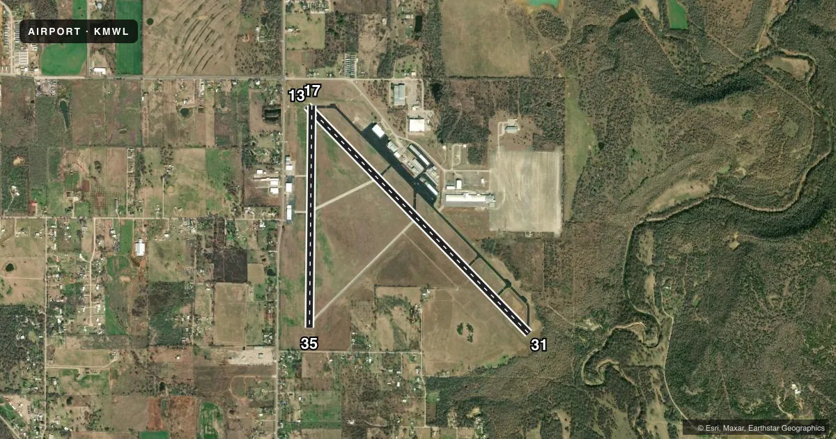
Runways & pattern
Full pagePattern entry · RWY 13
LEFT TRAFFIC| Runway | Heading (°M) | Length | Surface | Traffic |
|---|---|---|---|---|
| 13/31Favored | 130° / 310° | 5,996 ft | ASPH | Standard L |
| 17/35 | 175° / 355° | 4,188 ft | ASPH | Standard L |
Runway end performance
| End | TORA | TODA | ASDA | LDA | VGSI | Approach lights | Obstruction |
|---|---|---|---|---|---|---|---|
| 13 | — | — | — | — | PAPI 4-box left(3°) | — | 9', fence, 201' from thr, 345' R of cntrln, slope 0 |
| 31 | — | — | — | — | PAPI 4-box left(3°) | — | 15', trees, 201' from thr, 130' R of cntrln, slope 0 |
| 17 | — | — | — | — | PAPI 2-box right(3°) | — | 35', trees, 556' from thr, 20' R of cntrln, slope 10 |
| 35 | — | — | — | — | PAPI 2-box left(4°) | — | 55', trees, 486' from thr, 185' R of cntrln, slope 5 |
Declared distances in feet. TORA = takeoff run available, TODA = takeoff distance, ASDA = accelerate-stop, LDA = landing distance.
Airport sketch
Runways drawn to scale from FAA survey coordinates, rendered over satellite imagery. Not for navigation.
Approaches & charts
ILS · 1
Services on the field
Fuel grades, oxygen, maintenance, ramp storage and lighting — as declared to the FAA by the airport operator.
Fuel & services
- Fuel
- 100LLA
- Oxygen (bulk)
- Not available
- Other services
- INSTR
Ramp & ground
- Transient storage
- Tie-down
- Landing fee
- No fee published
- Customs
- Not available
- Lighting schedule
- SEE RMK
- Beacon schedule
- SS-SR
- Beacon
- White / Green (civil land)(WG)
- Wind indicator
- Lighted
- Segmented circle
- Yes
Fuel & FBOs
Cheapest 100LL and Jet A on the field and nearby. Always confirm with the FBO before taxi.
Airport notes
Surface conditions, obstructions, local procedures, lighting outages and other notes published with each FAA cycle.
General notes
- RWY 13/31 RWY ENDS NOT VSB FM OPPOSITE END.
- FOR CD IF UNA TO CTC ON FSS FREQ, CTC FORT WORTH ARTCC AT 817-858-7584.
- RWY 13, DITCH 6 FT DEEP, 8 FT WIDE, 50 FT LONG, BTWN RWY THR & TWY A.
Lighting notes
- DUSK-DAWN. MIRL RWYS 13/31 & 17/35 PRESET LOW INTST; TO INCR INTST ACTVT - CTAF.
Fuel notes
- 100LLFOR FUEL AFT HRS CALL 940-328-7770.
Approach & departure obstructions
- 138 FT FENCE, 199 FT DSTC, 347 FT R, 15 FT RD, 199 FT DSTC, 390 FT R.
- 3110 FT GND 0-199 DSTC, 15 FT TREES, 175 FT DSTC, 150 FT R.
- 35PAPI UNUSBL BYD 3 DEG L OF CNTRLN.
- 139 FT FENCE POLE, 8 FT FENCE. APCH SLOPE 10:1 AT DSPLCD THR OVR 35 FT TREES, 560 FT FM DSPLCD THR 248 FT R.
- 31APCH SLOPE 0:1 TO DSPLCD THR OVR 10 FT GND 0 FT DSTC, 180 FT LEFT.
- 35APCH SLOPE 14:1 TO DSPLCD THR.
Other notes
- THIS AIRPORT HAS BEEN SURVEYED BY THE NATIONAL GEODETIC SURVEY.
VFR map & nearby airports
VFR sectional. Tap any ICAO chip to open that airport.
Key facts · KMWL
Answer card- ICAO
- KMWL
- Name
- MINERAL WELLS RGNL
- Location
- MINERAL WELLS, TEXAS
- Elevation
- 973.6 ft MSL
- Traffic pattern altitude
- 1,973.6 ft MSL (1,000 AGL)
- Control tower
- Non-towered (use CTAF)
- Total runways
- 2
- Longest runway
- 13/31 · 5,996 ft
- Published ILS approaches
- 1
- Published frequencies
- 2
- Magnetic variation
- 6°
- Current flight rules
- VFR
- Current wind
- 150° at 9 kt
- Favored runway now
- RWY 13
Mineral Wells Regional Airport sits in Mineral Wells, Texas. Field elevation is 973.6 ft MSL. It has 2 asphalt runways. The longest is 5,996 ft on 13/31. This is an uncontrolled field. CTAF and UNICOM are both 122.725. The airport has 1 ILS approach, with service to runway 31.
Pattern altitude is not published. Use the standard 1,000 ft AGL for light piston operations unless the current Chart Supplement says otherwise. The on-field FBO is Mineral Wells Regional Airport. It carries 100LL and Jet A Prist. Call (940) 328-7808 for the field. After hours fuel for 100LL is handled by phone at 940-328-7770.
A few runway notes matter here. Runway 13/31 end visibility is limited from the opposite end. Runway 31 has obstacles near the approach path. Runway 35 also has published slope and PAPI limits. Runway lights are preset to low intensity from dusk to dawn. Use the CTAF to increase intensity. The field has no tower, so expect self-announce traffic and stay sharp on the pattern. Check the current Chart Supplement for any noise or curfew restrictions before flying in.