METAR & TAF 50F
50F does not publish a METAR.
Showing the nearest reporting station: KFWS (FORT WORTH SPINKS) · 14.3 NM away. Conditions at 50F may differ.
METAR · KFWS
Observed 10:35Z
KFWS 271035Z AUTO 21008KT 10SM 25/21 A2994 RMK AO2 T02520212 $
- Wind
- 210° @ 8 kt
- Visibility
- 10 SM
- Temp / Dew
- 25°C / 21°C
- Altimeter
- 29.94 inHg
- Clouds
- Clear
- Density alt
- 2,258 ft
- Ceiling
- Unlimited
- Rules
- VFR
Airport info & contacts
Manager on record, flight service, ARTCC, attendance schedule and pattern altitude — published by the FAA and refreshed every 28 days.
Location
- From city
- 17 NM SW
- VFR sectional
- DALLAS-FT WORTH
- ARTCC
- ZFW · FORT WORTH
- NOTAM facility
- FTW (NOTAM-D)
Airport manager
- Name
- JASON SMITH
- Phone
- 682-260-3778
- Address
- 101 CONSTELLATION DR, CRESSON TX 76035
Flight service · Hours
- FSS FTW
- FORT WORTH1-800-WX-BRIEF
- Attendance
- MON-SAT · DALGT
Frequencies
Tap any row to copy the frequency to your clipboard.
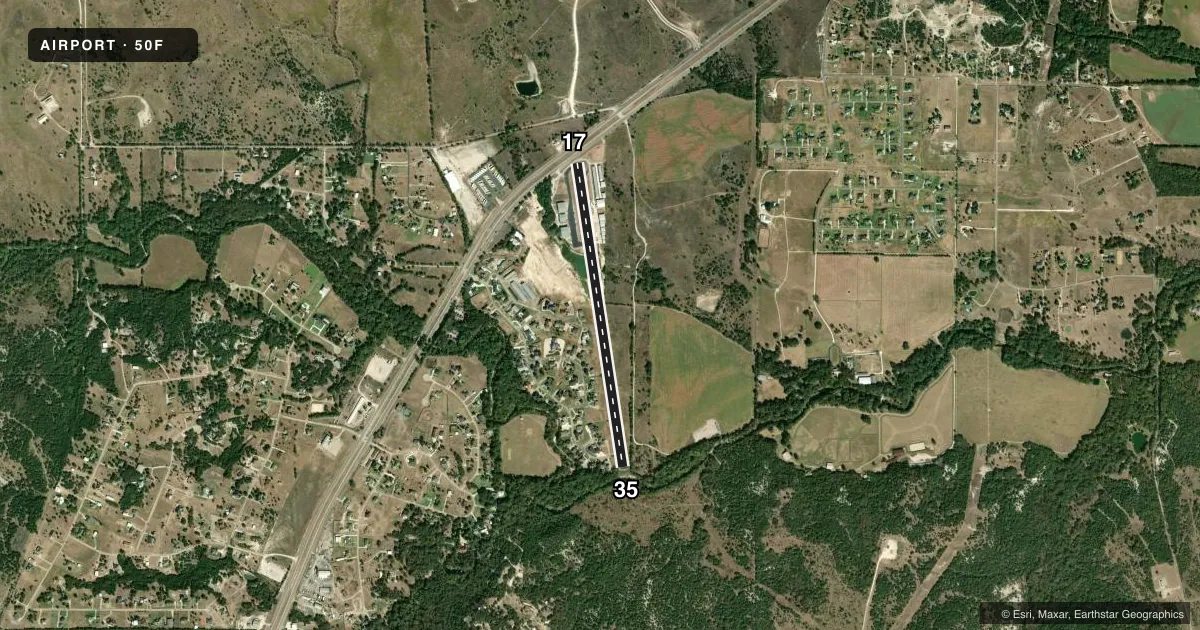
Runways & pattern
Full pagePattern entry · RWY 17
LEFT TRAFFICRunway end performance
| End | TORA | TODA | ASDA | LDA | VGSI | Approach lights | Obstruction |
|---|---|---|---|---|---|---|---|
| 17 | — | — | — | — | VASI 2-box left(3°) | — | 19', road, 201' from thr, 250' R of cntrln, slope 0 |
| 35 | — | — | — | — | VASI 2-box left(3.5°) | — | 30', trees, 201' from thr, 60' R of cntrln, slope 0 |
Declared distances in feet. TORA = takeoff run available, TODA = takeoff distance, ASDA = accelerate-stop, LDA = landing distance.
Airport sketch
Runways drawn to scale from FAA survey coordinates, rendered over satellite imagery. Not for navigation.
Approaches & charts
Services on the field
Fuel grades, oxygen, maintenance, ramp storage and lighting — as declared to the FAA by the airport operator.
Fuel & services
- Fuel
- 100LLA
- Other services
- INSTR,RNTL
Ramp & ground
- Transient storage
- Tie-down
- Lighting schedule
- SEE RMK
- Beacon schedule
- SS-SR
- Beacon
- White / Green (civil land)(WG)
- Wind indicator
- Lighted
- Segmented circle
- Yes
Fuel & FBOs
Cheapest 100LL and Jet A on the field and nearby. Always confirm with the FBO before taxi.
Airport notes
Surface conditions, obstructions, local procedures, lighting outages and other notes published with each FAA cycle.
General notes
- FOR CD CTC LONE STAR APCH AT 972-615-2799.
- DEER & WILDLIFE ON & INVOF RWY.
- ARPT CLSD TO TSNT STUDENT TFC.
- ACFT OVR 12500 LB MAX GWT PROHIBITED.
Lighting notes
- ACTVT MIRL RWY 17/35 - CTAF.
Fuel notes
- 100LLFUEL SELF SERVE.
Runway surface & condition
- 17/35NSTD RWY LGT SPACING, 100 FT BETWEEN RWY LGTS.
Approach & departure obstructions
- 1719 FT RD 0-199 FT DSTC 125 FT L/R.
- 3530 FT TREES, 0 FT DSTC, 100 FT R.
- 17DTHR LGTS & MKGS NOT COINCIDENT.
- 17APCH SLOPE 0:1 TO DTHR, 20 FT BLDG, 0 FT DSTC, 180 FT L.
- 35APCH RATIO 0:1 TO DTHR OVR 15 FT TREE, 0 FT DSTC, 120 FT R.
- 17DTHR LGTS & MKGS NOT COINCIDENT.
Other notes
- VFR ONLY.
- 1FOR SVCS AFT HRS CALL 817-752-4701.
- MANAGERBOURLANDAIRPORT50F@GMAIL.COM ALT PHONE 951-283-4076
- OWNERFBO PHONE.
VFR map & nearby airports
VFR sectional. Tap any ICAO chip to open that airport.
Key facts · 50F
Answer card- ICAO
- 50F
- Name
- BOURLAND FLD
- Location
- FORT WORTH, TEXAS
- Elevation
- 873.2 ft MSL
- Traffic pattern altitude
- 1,873.2 ft MSL (1,000 AGL)
- Control tower
- Non-towered (use CTAF)
- Total runways
- 1
- Longest runway
- 17/35 · 4,049 ft
- Published ILS approaches
- 0
- Published frequencies
- 4
- Magnetic variation
- 6°
- Current flight rules
- VFR
- Current wind
- 210° at 8 kt
- Favored runway now
- RWY 17
Bourland Fld is in Fort Worth, Texas. The field elevation is 873.2 ft MSL. It has one runway, 17/35, which is 4,049 ft long. There is no control tower. Towered services are not published here, so use the CTAF and current Chart Supplement for the latest local procedures.
No ILS approaches are published at 50F. The published pattern altitude is not listed, so plan on the standard 1,000 ft AGL for light piston traffic unless the current Chart Supplement says otherwise. The airport is VFR only. That matters here because the field also has published obstructions near both runway ends. Runway 17 has a displaced threshold with a building near the approach path. Runway 35 has trees near the approach path. Deer are also reported on and near the runway, so keep a sharp scan on taxi, takeoff and landing.
Bourland Field is the on-field FBO. It carries 100LL and Jet A with Prist. Runway lights on 17/35 activate on CTAF. Visual approach slope indicators on both runway ends operate continuously. For clearance delivery, contact Lone Star Approach. The airport is closed to aircraft over 12,500 lb maximum gross weight. It is also closed to transient student traffic. Runway hold short lines are nonstandard. Brief that before you taxi in.