METAR & TAF KCPT
Current METAR
Observed 09:35Z
KCPT 270935Z AUTO 18006KT 9SM CLR 25/22 A2990 RMK AO2 T02470220 $
- Wind
- 180° @ 6 kt
- Visibility
- 9 SM
- Temp / Dew
- 25°C / 22°C
- Altimeter
- 29.90 inHg
- Clouds
- CLR
- Density alt
- 2,284 ft
- Ceiling
- Unlimited
- Rules
- VFR
Airport info & contacts
Manager on record, flight service, ARTCC, attendance schedule and pattern altitude — published by the FAA and refreshed every 28 days.
Location
- From city
- 2 NM NW
- VFR sectional
- DALLAS-FT WORTH
- ARTCC
- ZFW · FORT WORTH
- NOTAM facility
- CPT (NOTAM-D)
Airport manager
- Name
- CLINTON TUGGLE
- Phone
- 817-641-5456
- Address
- 1650 AIRPORT DRIVE, CLEBURNE TX 76033
Flight service · Hours
- FSS FTW
- FORT WORTH1-800-WX-BRIEF
- Attendance
- MON-FRI · 0800-1700
- SAT-SUN · 0800-1600
Frequencies
Tap any row to copy the frequency to your clipboard.
Runways & pattern
Full pagePattern entry · RWY 15
RIGHT TRAFFICRunway end performance
| End | TORA | TODA | ASDA | LDA | VGSI | Approach lights | Obstruction |
|---|---|---|---|---|---|---|---|
| 15 | — | — | — | — | PAPI 4-box left(3°) | — | 25', trees, 750' from thr, 60' R of cntrln, slope 22 |
| 33 | — | — | — | — | — | — | 32', pole, 1340' from thr, 285' R of cntrln, slope 35 |
Declared distances in feet. TORA = takeoff run available, TODA = takeoff distance, ASDA = accelerate-stop, LDA = landing distance.
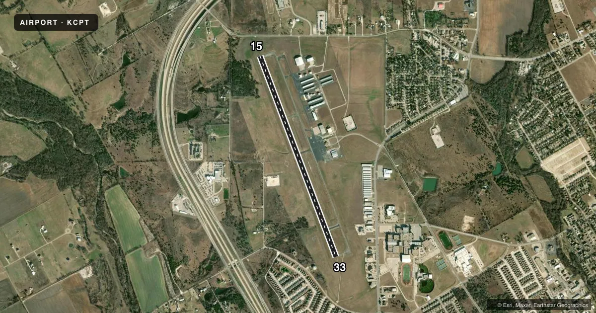
Airport sketch
Runways drawn to scale from FAA survey coordinates, rendered over satellite imagery. Not for navigation.
Approaches & charts
ILS · 1
Services on the field
Fuel grades, oxygen, maintenance, ramp storage and lighting — as declared to the FAA by the airport operator.
Fuel & services
- Fuel
- 100LLA+
- Oxygen (bottled)
- HIGH/LOW
- Oxygen (bulk)
- HIGH/LOW
- Airframe repair
- Major
- Power plant repair
- Major
- Other services
- AVNCS,CHTR,INSTR,RNTL
Ramp & ground
- Transient storage
- Tie-down
- Hangar
- Landing fee
- No fee published
- Customs
- Not available
- Lighting schedule
- SEE RMK
- Beacon schedule
- SS-SR
- Beacon
- White / Green (civil land)(WG)
- Wind indicator
- Lighted
- Segmented circle
- Yes
Fuel & FBOs
Cheapest 100LL and Jet A on the field and nearby. Always confirm with the FBO before taxi.
Airport notes
Surface conditions, obstructions, local procedures, lighting outages and other notes published with each FAA cycle.
General notes
- FOR CD CTC LONE STAR APCH AT 972-615-2799.
- HOT REFUELING OPNS PROHIBITED.
Lighting notes
- ACTVT PAPI RWY 15; MIRL RWY 15/33 - CTAF.
Fuel notes
- 100LLFUEL 24 HR SELF-SERVE. FOR ATTENDANT AFT HRS CALL 817-933-1650, CALL-IN FEE.
Approach & departure obstructions
- 15APCH SLOPE 37:1 TO DTHR.
Other notes
- THIS AIRPORT HAS BEEN SURVEYED BY THE NATIONAL GEODETIC SURVEY.
VFR map & nearby airports
VFR sectional. Tap any ICAO chip to open that airport.
Key facts · KCPT
Answer card- ICAO
- KCPT
- Name
- CLEBURNE RGNL
- Location
- CLEBURNE, TEXAS
- Elevation
- 854.2 ft MSL
- Traffic pattern altitude
- 1,854.2 ft MSL (1,000 AGL)
- Control tower
- Non-towered (use CTAF)
- Total runways
- 1
- Longest runway
- 15/33 · 5,697 ft
- Published ILS approaches
- 1
- Published frequencies
- 4
- Magnetic variation
- 6°
- Current flight rules
- VFR
- Current wind
- 180° at 6 kt
- Favored runway now
- RWY 15
Cleburne Regional Airport is in Cleburne, Texas. The field elevation is 854.2 ft MSL. KCPT has one runway, 15/33, at 5,697 ft. There is no control tower, so use CTAF 122.8 for traffic and lighting activation. The airport has 1 ILS approach to runway 15. Pattern altitude is not published. Use 1,000 ft AGL for light piston traffic unless the current Chart Supplement says otherwise.
The on-field FBO is Cleburne Regional Airport. It carries 100LL and Jet A with Prist. Fuel is available 24 hours self-serve. If you need an attendant after hours, call the number in the Chart Supplement. Hot refueling is prohibited. The published remarks also note that the PAPI for runway 15 and the medium intensity runway lights for 15 and 33 are activated on CTAF. Clearance delivery is handled through Lone Star Approach. The airport has been surveyed by the National Geodetic Survey.
For a first-time arrival, the main things to plan for are the non-towered pattern, the published ILS to runway 15 and the displaced threshold approach slope note for runway 15. Check the current Chart Supplement for any additional operational notes before you go.