METAR & TAF KGKY
Current METAR
Observed 04:53Z
KGKY 270453Z AUTO 17007KT 10SM CLR 30/19 A2995 RMK AO2 SLP132 T03000194
- Wind
- 170° @ 7 kt
- Visibility
- 10 SM
- Temp / Dew
- 30°C / 19°C
- Altimeter
- 29.95 inHg
- Clouds
- CLR
- Density alt
- 2,542 ft
- Ceiling
- Unlimited
- Rules
- VFR
Airport info & contacts
Manager on record, flight service, ARTCC, attendance schedule and pattern altitude — published by the FAA and refreshed every 28 days.
Location
- From city
- 4 NM S
- VFR sectional
- DALLAS-FT WORTH
- ARTCC
- ZFW · FORT WORTH
- NOTAM facility
- GKY (NOTAM-D)
Airport manager
- Name
- TRENT BALLARD
- Phone
- 817-459-5571
- Address
- 5000 S. COLLINS, STE 100, ARLINGTON TX 76018-3231
Flight service · Hours
- FSS FTW
- FORT WORTH1-800-WX-BRIEF
- Attendance
- ALL
Frequencies
Tap any row to copy the frequency to your clipboard.
Runways & pattern
Full pagePattern entry · RWY 16
LEFT TRAFFICRunway end performance
| End | TORA | TODA | ASDA | LDA | VGSI | Approach lights | Obstruction |
|---|---|---|---|---|---|---|---|
| 16 | — | — | — | — | PAPI 4-box left(3°) | — | — |
| 34 | — | — | — | — | PAPI 4-box left(3°) | MALSR | 36', trees, 1235' from thr, 188' R of cntrln, slope 28 |
Declared distances in feet. TORA = takeoff run available, TODA = takeoff distance, ASDA = accelerate-stop, LDA = landing distance.
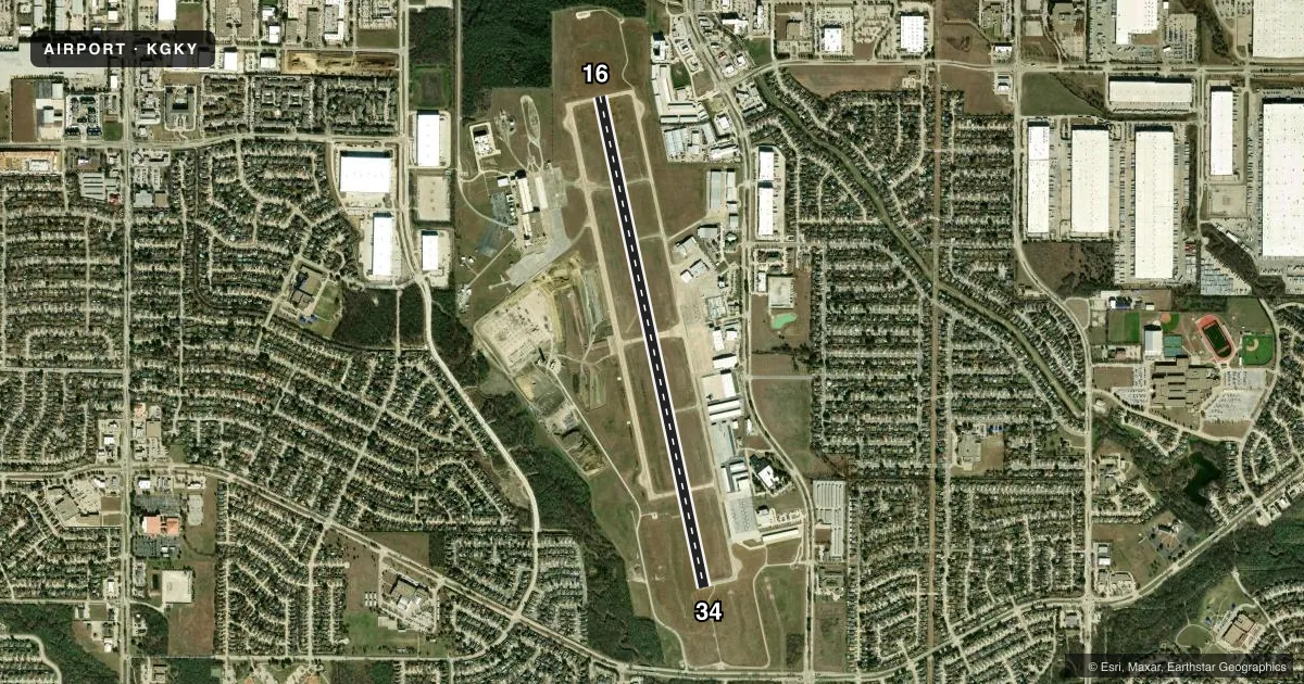
Airport sketch
Runways drawn to scale from FAA survey coordinates, rendered over satellite imagery. Not for navigation.
Approaches & charts
ILS · 1
Services on the field
Fuel grades, oxygen, maintenance, ramp storage and lighting — as declared to the FAA by the airport operator.
Fuel & services
- Fuel
- 100LLAA+
- Oxygen (bottled)
- Low pressure
- Oxygen (bulk)
- Not available
- Airframe repair
- Major
- Power plant repair
- Major
- Other services
- AVNCS,INSTR,RNTL,SALES
Ramp & ground
- Transient storage
- Tie-down
- Hangar
- Landing fee
- No fee published
- Customs
- Not available
- Lighting schedule
- SEE RMK
- Beacon schedule
- SS-SR
- Beacon
- White / Green (civil land)(WG)
- Wind indicator
- Lighted
- Segmented circle
- Yes
Fuel & FBOs
Cheapest 100LL and Jet A on the field and nearby. Always confirm with the FBO before taxi.
Airport notes
Surface conditions, obstructions, local procedures, lighting outages and other notes published with each FAA cycle.
General notes
- EXTSV HEL TFC WEST OF RWY.
Lighting notes
- MIRL RWY 16/34 PRESET MED INTST; HIGHER INTST BY ATCT REQ. WHEN ATCT CLSD ACTVT MALSR RWY 34 - CTAF.
Fuel notes
- 100LL100LL FULL & SELF SERVE.
VFR map & nearby airports
VFR sectional. Tap any ICAO chip to open that airport.
Key facts · KGKY
Answer card- ICAO
- KGKY
- Name
- ARLINGTON MUNI
- Location
- ARLINGTON, TEXAS
- Elevation
- 628.3 ft MSL
- Traffic pattern altitude
- 1,628.3 ft MSL (1,000 AGL)
- Control tower
- Towered · 0700-2100
- Total runways
- 1
- Longest runway
- 16/34 · 6,080 ft
- Published ILS approaches
- 1
- Published frequencies
- 7
- Magnetic variation
- 6°
- Current flight rules
- VFR
- Current wind
- 170° at 7 kt
- Favored runway now
- RWY 16
Arlington Muni sits in Arlington, Texas. Field elevation is 628.3 ft MSL. The airport has one runway, 16/34, which is 6,080 ft long. The tower is open daily from 0700 to 2100. Runway 34 has the published ILS. Pattern altitude is not published. Use the standard 1,000 ft AGL for light piston traffic unless the current Chart Supplement says otherwise. That puts the pattern at about 1,628 ft MSL.
Arlington Air Center is on the field. It carries 100LL and Jet A. 100LL is available full service and self service. The runway has medium intensity lighting preset. Higher intensity lighting can be requested from ATC. When the tower is closed, pilots can activate the medium intensity approach lighting system with runway alignment indicator lights on runway 34 on CTAF.
Expect busy helicopter traffic west of the runway. That matters on arrival and departure. Keep a sharp lookout in the pattern and on taxi. The airport is in the Dallas area, so traffic flow can be active. Check the current Chart Supplement for any published noise or curfew restrictions before flying into the field.