METAR & TAF KJWY
Current METAR
Observed 06:15Z
KJWY 270615Z AUTO 16004KT 10SM CLR 26/21 A2997 RMK AO2 T02560208 $
- Wind
- 160° @ 4 kt
- Visibility
- 10 SM
- Temp / Dew
- 26°C / 21°C
- Altimeter
- 29.97 inHg
- Clouds
- CLR
- Density alt
- 2,159 ft
- Ceiling
- Unlimited
- Rules
- VFR
Airport info & contacts
Manager on record, flight service, ARTCC, attendance schedule and pattern altitude — published by the FAA and refreshed every 28 days.
Location
- From city
- 5 NM SE
- VFR sectional
- DALLAS-FT WORTH
- ARTCC
- ZFW · FORT WORTH
- NOTAM facility
- JWY (NOTAM-D)
Airport manager
- Name
- SHARLETTE WRIGHT
- Phone
- 972-923-0080
- Address
- 131 AIRPORT DRIVE, STE 101, MIDLOTHIAN TX 76065
Flight service · Hours
- FSS FTW
- FORT WORTH1-800-WX-BRIEF
- Attendance
- MAR-OCT · MON-SAT · 0800-1900
- NOV-FEB · MON-SAT · 0800-1800
- MAR-OCT · SUN · 0900-1900
- NOV-FEB · SUN · 0900-1800
Frequencies
Tap any row to copy the frequency to your clipboard.
Runways & pattern
Full pagePattern entry · RWY 18
LEFT TRAFFICRunway end performance
| End | TORA | TODA | ASDA | LDA | VGSI | Approach lights | Obstruction |
|---|---|---|---|---|---|---|---|
| 18 | — | — | — | — | PAPI 4-box right(3°) | — | 26', trees, 1254' from thr, 630' R of cntrln, slope 40 |
| 36 | — | — | — | — | PAPI 4-box left(3°) | — | 27', pline, 224' from thr, 503' R of cntrln, slope 0 |
Declared distances in feet. TORA = takeoff run available, TODA = takeoff distance, ASDA = accelerate-stop, LDA = landing distance.
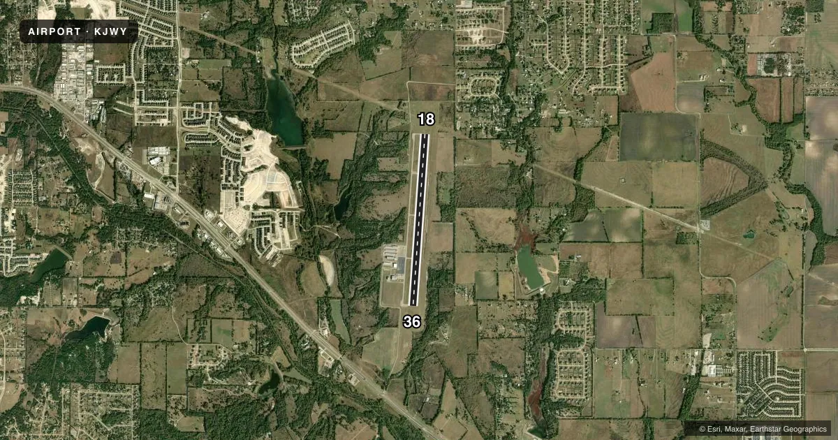
Airport sketch
Runways drawn to scale from FAA survey coordinates, rendered over satellite imagery. Not for navigation.
Approaches & charts
Services on the field
Fuel grades, oxygen, maintenance, ramp storage and lighting — as declared to the FAA by the airport operator.
Fuel & services
- Fuel
- 100LLA
- Airframe repair
- Major
- Power plant repair
- Major
- Other services
- AVNCS,GLD,INSTR,SALES,SURV,TOW
Ramp & ground
- Transient storage
- Tie-down
- Lighting schedule
- SEE RMK
- Beacon schedule
- SS-SR
- Beacon
- White / Green (civil land)(WG)
- Wind indicator
- Lighted
- Segmented circle
- Yes
Fuel & FBOs
Cheapest 100LL and Jet A on the field and nearby. Always confirm with the FBO before taxi.
Airport notes
Surface conditions, obstructions, local procedures, lighting outages and other notes published with each FAA cycle.
General notes
- GLIDER OPNS ON ARPT.
- FOR CD CTC LONE STAR APCH AT 972-615-2799.
Lighting notes
- ACTVT REIL RWY 18; MIRL RWY 18/36 - CTAF.
Fuel notes
- 100LLFOR FUEL & SVCS AFT HRS CALL 214-762-8286 OR 972-979-5723.
Approach & departure obstructions
- 18CONTROLLING OBSTRUCTION EXCEEDS A 45 DEGREE SLOPE
Other notes
- OWNERWAXAHACHIE CITY HALL.
VFR map & nearby airports
VFR sectional. Tap any ICAO chip to open that airport.
Key facts · KJWY
Answer card- ICAO
- KJWY
- Name
- MID-WAY RGNL
- Location
- MIDLOTHIAN/WAXAHACHIE, TEXAS
- Elevation
- 727 ft MSL
- Traffic pattern altitude
- 1,727 ft MSL (1,000 AGL)
- Control tower
- Non-towered (use CTAF)
- Total runways
- 1
- Longest runway
- 18/36 · 6,500 ft
- Published ILS approaches
- 0
- Published frequencies
- 4
- Magnetic variation
- 6°
- Current flight rules
- VFR
- Current wind
- 160° at 4 kt
- Favored runway now
- RWY 18
Mid-Way Rgnl Airport sits in Midlothian/Waxahachie, Texas. Field elevation is 727 ft MSL. The airport has one runway. Runway 18/36 is 6,500 ft long with asphalt pavement. There is no control tower. Clearance delivery is handled by Lone Star Approach. The published pattern altitude is not listed, so use the standard 1,000 ft AGL for light piston traffic unless the current Chart Supplement says otherwise.
There are no ILS approaches published here. Southern Star Aviation is the on-field FBO. It carries 100LL and Jet A. Call the FBO directly for current service details before you go. Published remarks also note that runway end identifier lights are on runway 18. Medium intensity runway lights are activated on runways 18 and 36 via CTAF. Glider operations occur on the airport, so keep your scan active in the pattern and on final.
One item to watch is the obstruction off runway 18. The published note says it exceeds a 45 degree slope. That makes the 18 end worth a close look on departure and arrival planning. The airport is non-towered, so standard CTAF discipline matters. Check the current Chart Supplement for any noise or curfew restrictions before flying into the field.