METAR & TAF KLNC
Current METAR
Observed 18:35Z
KLNC 101835Z AUTO 19014G18KT 10SM OVC019 24/20 A2993 RMK AO2 T02380200
- Wind
- 190° @ 14G18 kt
- Visibility
- 10 SM
- Temp / Dew
- 24°C / 20°C
- Altimeter
- 29.93 inHg
- Clouds
- OVC
- Density alt
- 1,689 ft
- Ceiling
- 1,900 ft AGL
- Rules
- MVFR
Airport info & contacts
Manager on record, flight service, ARTCC, attendance schedule and pattern altitude — published by the FAA and refreshed every 28 days.
Location
- From city
- 2 NM S
- VFR sectional
- DALLAS-FT WORTH
- ARTCC
- ZFW · FORT WORTH
- NOTAM facility
- LNC (NOTAM-D)
Airport manager
- Name
- KELLEN BENBROOK
- Phone
- 972-227-5721
- Address
- 950 FERRIS ROAD, LANCASTER TX 75146
Flight service · Hours
- FSS FTW
- FORT WORTH1-800-WX-BRIEF
- Attendance
- MON-THUR · 0700-1800
- FRI-SUN · 0700-1900
Frequencies
Tap any row to copy the frequency to your clipboard.
Runways & pattern
Full pagePattern entry · RWY 13
LEFT TRAFFICRunway end performance
| End | TORA | TODA | ASDA | LDA | VGSI | Approach lights | Obstruction |
|---|---|---|---|---|---|---|---|
| 13 | — | — | — | — | PAPI 4-box left(3°) | — | — |
| 31 | — | — | — | — | PAPI 4-box left(3°) | — | 18', trees, 340' from thr, 333' R of cntrln, slope 7 |
Declared distances in feet. TORA = takeoff run available, TODA = takeoff distance, ASDA = accelerate-stop, LDA = landing distance.
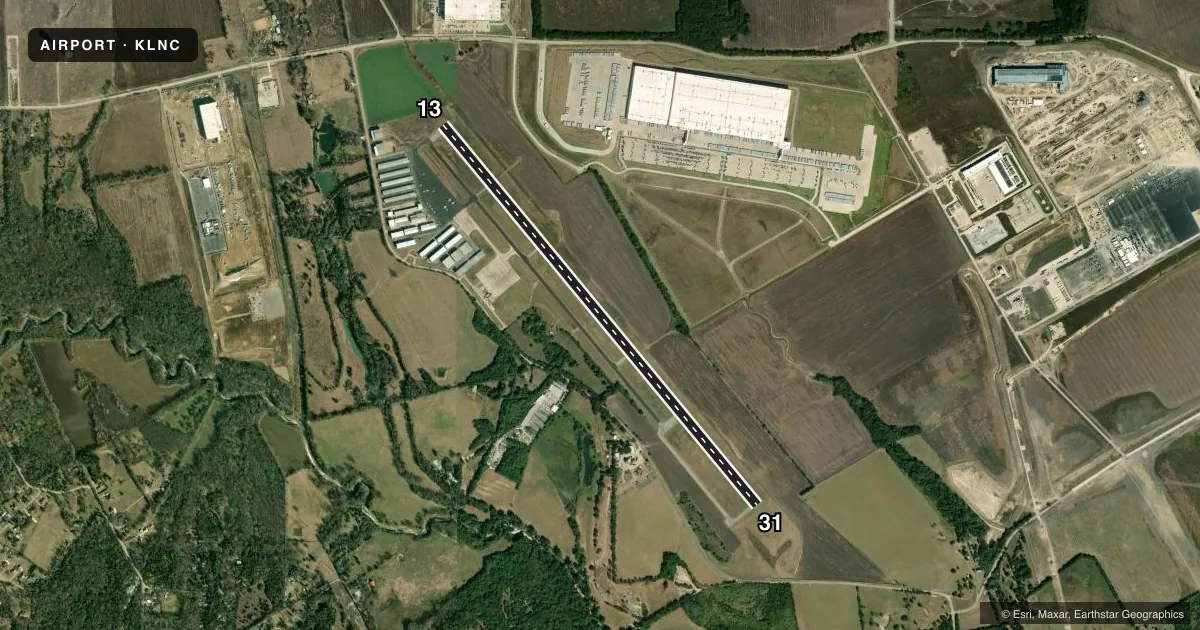
Airport sketch
Runways drawn to scale from FAA survey coordinates, rendered over satellite imagery. Not for navigation.
Approaches & charts
Services on the field
Fuel grades, oxygen, maintenance, ramp storage and lighting — as declared to the FAA by the airport operator.
Fuel & services
- Fuel
- 100LLA+
- Oxygen (bottled)
- Not available
- Oxygen (bulk)
- Not available
- Airframe repair
- Major
- Power plant repair
- Major
- Other services
- AVNCS,INSTR,RNTL
Ramp & ground
- Transient storage
- Tie-down
- Landing fee
- No fee published
- Customs
- Not available
- Lighting schedule
- SEE RMK
- Beacon schedule
- SS-SR
- Beacon
- White / Green (civil land)(WG)
- Wind indicator
- Lighted
- Segmented circle
- Yes
Fuel & FBOs
Cheapest 100LL and Jet A on the field and nearby. Always confirm with the FBO before taxi.
Airport notes
Surface conditions, obstructions, local procedures, lighting outages and other notes published with each FAA cycle.
General notes
- FULL ON AUTO-ROTATIONS, SLIDING SKID LDG OR TKOFS BY SKID TYPE HELS ON ANY PAVED SFC NOT AUTH.
- WILDLIFE ON & INVOF ARPT.
- N RAMP HEL PRKG CIRCLES ROTARY WING USE ONLY, APCH AND DEP NA.
- FOR CD CTC LONE STAR APCH AT 972-615-2799.
Lighting notes
- ACTVT MIRL RWY 13/31 - CTAF.
Other notes
- 2ARPT UNATNDD THANKSGIVING, CHRISTMAS EVE 1800Z THRU CHRISTMAS.
- MANAGERARPT ADMIN: 972-218-1273.
VFR map & nearby airports
VFR sectional. Tap any ICAO chip to open that airport.
Key facts · KLNC
Answer card- ICAO
- KLNC
- Name
- LANCASTER RGNL
- Location
- LANCASTER, TEXAS
- Elevation
- 501.1 ft MSL
- Traffic pattern altitude
- 1,501.1 ft MSL (1,000 AGL)
- Control tower
- Non-towered (use CTAF)
- Total runways
- 1
- Longest runway
- 13/31 · 6,500 ft
- Published ILS approaches
- 0
- Published frequencies
- 4
- Magnetic variation
- 6°
- Current flight rules
- MVFR
- Current wind
- 190° at 14 kt
- Favored runway now
- RWY 13
Lancaster RGNL is in Lancaster, Texas, south of Dallas. Field elevation is 501.1 ft MSL. The airport has one runway. Runway 13/31 is 6,500 ft long, which is the longest on the field. There is no control tower. The published pattern altitude is not listed, so use 1,500 ft MSL for light piston traffic unless the current Chart Supplement says otherwise.
No ILS approaches are published here. Lone Star Approach handles the approach and departure side on 125.2 or 343.65. CTAF and UNICOM are both 122.7. Runway 13/31 has medium intensity lights that are activated by the CTAF. That matters if you are planning a night arrival.
Lancaster Regional Airport is the on-field FBO. It carries 100LL and Jet A Prist. Call (972) 227-5721 for current ramp or fuel details. The published remarks also note wildlife on and near the airport. Helicopter pilots should pay attention to the published restrictions on full autorotations and skid operations on paved surfaces. The north ramp helicopter parking circles are for rotary wing use only. For clearance delivery, contact Lone Star Approach at 972-615-2799. The airport is unattended from 1800 Zulu on Christmas Eve through Christmas and on Thanksgiving.