METAR & TAF KRBD
Current METAR
Observed 04:53Z
KRBD 270453Z AUTO 18006KT 10SM CLR 29/20 A2995 RMK AO2 SLP133 T02940200
- Wind
- 180° @ 6 kt
- Visibility
- 10 SM
- Temp / Dew
- 29°C / 20°C
- Altimeter
- 29.95 inHg
- Clouds
- CLR
- Density alt
- 2,462 ft
- Ceiling
- Unlimited
- Rules
- VFR
Airport info & contacts
Manager on record, flight service, ARTCC, attendance schedule and pattern altitude — published by the FAA and refreshed every 28 days.
Location
- From city
- 6 NM SW
- VFR sectional
- DALLAS-FT WORTH
- ARTCC
- ZFW · FORT WORTH
- NOTAM facility
- RBD (NOTAM-D)
Airport manager
- Name
- RAFAEL GARZA JR.
- Phone
- 214-670-7612
- Address
- 5303 CHALLENGER DR, DALLAS TX 75237
Flight service · Hours
- FSS FTW
- FORT WORTH1-800-WX-BRIEF
- Attendance
- 0600-2000
Frequencies
Tap any row to copy the frequency to your clipboard.
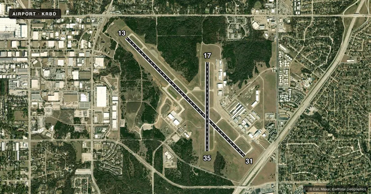
Runways & pattern
Full pagePattern entry · RWY 17
LEFT TRAFFIC| Runway | Heading (°M) | Length | Surface | Traffic |
|---|---|---|---|---|
| 13/31 | 129° / 309° | 7,136 ft | CONC | Standard L |
| 17/35Favored | 174° / 354° | 3,800 ft | CONC | Standard L |
Runway end performance
| End | TORA | TODA | ASDA | LDA | VGSI | Approach lights | Obstruction |
|---|---|---|---|---|---|---|---|
| 13 | 6,766' | 7,136' | 6,622' | 5,537' | PAPI 4-box left(3°) | — | 42', trees, 201' from thr, 457' R of cntrln, slope 0 |
| 31 | 6,051' | 7,136' | 7,101' | 6,601' | PAPI 4-box right(3°) | — | 7', road, 547' from thr, 513' R of cntrln, slope 49 |
| 17 | — | — | — | — | PAPI 4-box right(3°) | — | 18', trees, 770' from thr, 800' R of cntrln, slope 31 |
Declared distances in feet. TORA = takeoff run available, TODA = takeoff distance, ASDA = accelerate-stop, LDA = landing distance.
Airport sketch
Runways drawn to scale from FAA survey coordinates, rendered over satellite imagery. Not for navigation.
Approaches & charts
ILS · 1
Services on the field
Fuel grades, oxygen, maintenance, ramp storage and lighting — as declared to the FAA by the airport operator.
Fuel & services
- Fuel
- 100LLA
- Oxygen (bulk)
- HIGH/LOW
- Airframe repair
- Major
- Power plant repair
- Major
- Other services
- AVNCS,CHTR,INSTR,RNTL,SALES
Ramp & ground
- Transient storage
- Tie-down
- Hangar
- Lighting schedule
- SEE RMK
- Beacon schedule
- SS-SR
- Beacon
- White / Green (civil land)(WG)
- Wind indicator
- Lighted
- Segmented circle
- Yes
Fuel & FBOs
Cheapest 100LL and Jet A on the field and nearby. Always confirm with the FBO before taxi.
Airport notes
Surface conditions, obstructions, local procedures, lighting outages and other notes published with each FAA cycle.
General notes
- BIRDS & WILDLIFE ON & INVOF ARPT.
Lighting notes
- WHEN ATCT CLSD MIRL RWYS 13/31& 17/35 PRESET LOW INTST; TO INCR INTST ACTVT - CTAF.
Fuel notes
- 100LLFUEL AVBL 24 HR.
Approach & departure obstructions
- 1325 FT TREES, 0-199 FT DSTC, 399 FT R. 15 FT CONC WALL, 0 FT DSTC, 385 L.
- 13APCH SLOPE 0:1 TO DSPLCD THLD OVR 20 FT TREES, 0 FT DSTC, 395 FT R.
Other notes
- PRE-DATES ACT.
- 1ON CALL AFT HRS.
VFR map & nearby airports
VFR sectional. Tap any ICAO chip to open that airport.
Key facts · KRBD
Answer card- ICAO
- KRBD
- Name
- DALLAS EXEC
- Location
- DALLAS, TEXAS
- Elevation
- 660.5 ft MSL
- Traffic pattern altitude
- 1,660.5 ft MSL (1,000 AGL)
- Control tower
- Towered · 0700-2100
- Total runways
- 2
- Longest runway
- 13/31 · 7,136 ft
- Published ILS approaches
- 1
- Published frequencies
- 9
- Magnetic variation
- 6°
- Current flight rules
- VFR
- Current wind
- 180° at 6 kt
- Favored runway now
- RWY 17
Dallas Exec is in Dallas, Texas. The field elevation is 660.5 ft MSL. It has two concrete runways. The longest is 7,136 ft on runway 13/31. The tower is open 0700-2100. One ILS is published for runway 31.
Pattern altitude is not published. Use 1,000 ft AGL for light piston traffic unless the current Chart Supplement says otherwise. That puts the pattern at about 1,660.5 ft MSL based on the field elevation. The airport sits in busy metro airspace, so expect a high-traffic environment. Stay sharp on radio work and sequencing.
Jet Access and Ambassador Jet Center are on the field. Both carry 100LL, Jet A and Jet A Prist. Fuel is available 24 hours. Airport services are available on call after hours. When the tower is closed, the runway lights on 13/31 and 17/35 are preset to low intensity. Use the CTAF to increase lighting intensity if needed.
Watch the published obstructions near runway 13. Trees and a concrete wall are noted close to the runway environment. Birds and wildlife are also reported on and near the airport. Check the current Chart Supplement and brief the approach carefully before you go in.