METAR & TAF KGPM
Current METAR
Observed 07:55Z
KGPM 270755Z AUTO 20006KT 10SM CLR 28/19 A2996 RMK AO2 T02840188
- Wind
- 200° @ 6 kt
- Visibility
- 10 SM
- Temp / Dew
- 28°C / 19°C
- Altimeter
- 29.96 inHg
- Clouds
- CLR
- Density alt
- 2,242 ft
- Ceiling
- Unlimited
- Rules
- VFR
Airport info & contacts
Manager on record, flight service, ARTCC, attendance schedule and pattern altitude — published by the FAA and refreshed every 28 days.
Location
- From city
- 4 NM SW
- VFR sectional
- DALLAS-FT WORTH
- Pattern altitude
- 612 ft AGL · 1,202 ft MSL
- ARTCC
- ZFW · FORT WORTH
- NOTAM facility
- GPM (NOTAM-D)
Airport manager
- Name
- MARK DIVITA
- Phone
- 972-237-7591
- Address
- 3116 S GT SOUTHWEST PKWY, GRAND PRAIRIE TX 75052-7238
Flight service · Hours
- FSS FTW
- FORT WORTH1-800-WX-BRIEF
- Attendance
- MARCH-OCTOBER · MON-SAT · 0800-2000
- NOVEMBER-FEBRUARY · MON-SAT · 0800-2000
- SUN · 0800-1900
Frequencies
Tap any row to copy the frequency to your clipboard.
Runways & pattern
Full pagePattern entry · RWY 18
LEFT TRAFFICRunway end performance
| End | TORA | TODA | ASDA | LDA | VGSI | Approach lights | Obstruction |
|---|---|---|---|---|---|---|---|
| 18 | — | — | — | — | VASI 4-box left(3°) | — | 20', bldg, 790' from thr, 0' R of cntrln, slope 29 |
| 36 | — | — | — | — | VASI 4-box left(4°) | — | 24', road, 600' from thr, 310' R of cntrln, slope 16 |
Declared distances in feet. TORA = takeoff run available, TODA = takeoff distance, ASDA = accelerate-stop, LDA = landing distance.
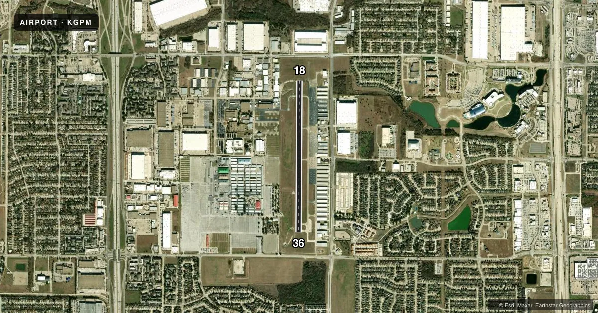
Airport sketch
Runways drawn to scale from FAA survey coordinates, rendered over satellite imagery. Not for navigation.
Approaches & charts
Services on the field
Fuel grades, oxygen, maintenance, ramp storage and lighting — as declared to the FAA by the airport operator.
Fuel & services
- Fuel
- 100LLA
- Oxygen (bottled)
- Not available
- Oxygen (bulk)
- Not available
- Airframe repair
- Major
- Power plant repair
- Major
- Other services
- AMB,INSTR,RNTL
Ramp & ground
- Transient storage
- Tie-down
- Hangar
- Landing fee
- No fee published
- Customs
- Not available
- Lighting schedule
- SEE RMK
- Beacon schedule
- SS-SR
- Beacon
- White / Green (civil land)(WG)
- Wind indicator
- Lighted
- Segmented circle
- Yes
Fuel & FBOs
Cheapest 100LL and Jet A on the field and nearby. Always confirm with the FBO before taxi.
Airport notes
Surface conditions, obstructions, local procedures, lighting outages and other notes published with each FAA cycle.
General notes
- EXTSV HEL TFC WEST SIDE OF ARPT.
- FOR CD WHEN ATCT IS CLSD CTC LONE STAR APCH AT 972-615-2799.
- WEST GRASS FOR ROTARY WING USE ONLY.
- NO ADS-B BILLING OR LDG FEES. GA TSNT RAMP FREE FOR SHORT TERM ONLY.
- 165 FT. WATER TWR, 1/4 MILE WEST OF RWY
Lighting notes
- MIRL RWY 18/36 PRESET LOW INTST; TO INCR INTST & ACTVT REIL RWY 36 AFT ATCT CLSD - CTAF.
Other notes
- THIS AIRPORT HAS BEEN SURVEYED BY THE NATIONAL GEODETIC SURVEY.
- TPA: 812 FT AGL FIXED WING, 612 FT AGL ROTARY WING.
VFR map & nearby airports
VFR sectional. Tap any ICAO chip to open that airport.
Key facts · KGPM
Answer card- ICAO
- KGPM
- Name
- GRAND PRAIRIE MUNI
- Location
- GRAND PRAIRIE, TEXAS
- Elevation
- 590 ft MSL
- Traffic pattern altitude
- 1,202 ft MSL (612 AGL)
- Control tower
- Towered · 0700-2100 DALGT TIME; 0800-1800 STANDARD TIME
- Total runways
- 1
- Longest runway
- 18/36 · 4,001 ft
- Published ILS approaches
- 0
- Published frequencies
- 6
- Magnetic variation
- 3°
- Current flight rules
- VFR
- Current wind
- 200° at 6 kt
- Favored runway now
- RWY 18
Grand Prairie Muni sits in Grand Prairie, Texas, at 590 ft MSL. It has one runway, 18/36, which is 4,001 ft long and paved with concrete. The airport is towered. Tower hours are 0700-2100 daylight time and 0800-1800 standard time. No ILS approaches are published here. Check the current FAA Chart Supplement and your approach setup before you go.
The published pattern altitude is 812 ft AGL for fixed wing aircraft. That is 1,402 ft MSL. Rotary wing pattern altitude is 612 ft AGL. That is 1,202 ft MSL. The field has a lot of helicopter traffic on the west side. The west grass area is for rotary wing use only. There is also a 165-foot water tower about one quarter mile west of the runway, so keep that in mind on arrival and departure.
Two FBOs are on the field. Grand Prairie Municipal Airport carries 100LL and Jet A. Spartan Flight Academy carries 100LL, Jet A and Jet A Prist. Published remarks say there are no ADS-B billing or landing fees. Short-term transient ramp use is free. When the tower is closed, clearance delivery goes through Lone Star Approach. Runway 18/36 has medium intensity lights preset to low. Use the CTAF to increase intensity and to activate runway end identifier lights on runway 36 after tower hours.