METAR & TAF T56
T56 does not publish a METAR.
Showing the nearest reporting station: KJWY (MID-WAY RGNL) · 3.4 NM away. Conditions at T56 may differ.
METAR · KJWY
Observed 05:35Z
KJWY 270535Z AUTO 16005KT 10SM CLR 26/21 A2998 RMK AO2 T02630206 $
- Wind
- 160° @ 5 kt
- Visibility
- 10 SM
- Temp / Dew
- 26°C / 21°C
- Altimeter
- 29.98 inHg
- Clouds
- CLR
- Density alt
- 2,213 ft
- Ceiling
- Unlimited
- Rules
- VFR
Airport info & contacts
Manager on record, flight service, ARTCC, attendance schedule and pattern altitude — published by the FAA and refreshed every 28 days.
Location
- From city
- 4 NM NE
- VFR sectional
- DALLAS-FT WORTH
- ARTCC
- ZFW · FORT WORTH
- NOTAM facility
- FTW (NOTAM-D)
Airport manager
- Name
- JAMES BARTH
- Phone
- 972-775-6403
- Address
- 3121 FALCON WAY, MIDLOTHIAN TX 76065
Flight service · Hours
- FSS FTW
- FORT WORTH1-800-WX-BRIEF
- Attendance
- Unattended
Frequencies
Tap any row to copy the frequency to your clipboard.
Runways & pattern
Full pagePattern entry · RWY 17
LEFT TRAFFICRunway end performance
| End | TORA | TODA | ASDA | LDA | VGSI | Approach lights | Obstruction |
|---|---|---|---|---|---|---|---|
| 17 | — | — | — | — | TRIL(5°) | — | 20', trees, 201' from thr, 40' R of cntrln, slope 0 |
| 35 | — | — | — | — | TRIL(5°) | — | 23', road, 211' from thr, 145' R of cntrln, slope 0 |
Declared distances in feet. TORA = takeoff run available, TODA = takeoff distance, ASDA = accelerate-stop, LDA = landing distance.
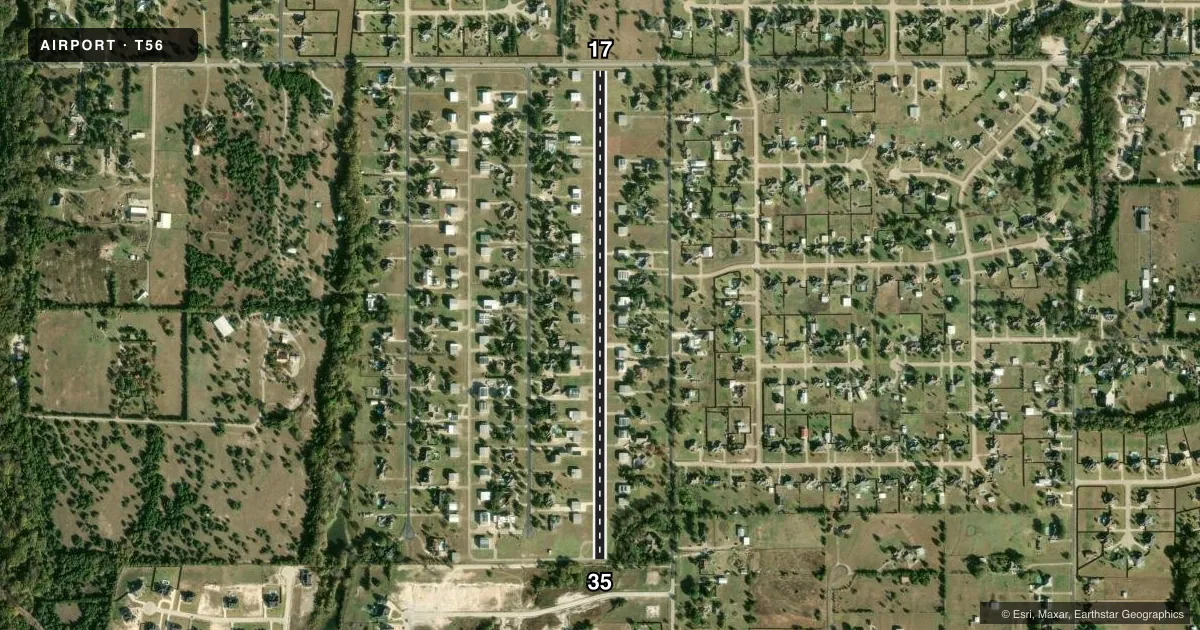
Airport sketch
Runways drawn to scale from FAA survey coordinates, rendered over satellite imagery. Not for navigation.
Approaches & charts
Services on the field
Fuel grades, oxygen, maintenance, ramp storage and lighting — as declared to the FAA by the airport operator.
Fuel & services
- Fuel
- Not available
Ramp & ground
- Transient storage
- Not published
- Lighting schedule
- SEE RMK
- Beacon schedule
- SS-SR
- Beacon
- White / Green (civil land)(WG)
- Wind indicator
- Yes
- Segmented circle
- No
Fuel & FBOs
Cheapest 100LL and Jet A on the field and nearby. Always confirm with the FBO before taxi.
Airport notes
Surface conditions, obstructions, local procedures, lighting outages and other notes published with each FAA cycle.
General notes
- FOR CD CTC FORT WORTH ARTCC 817-858-7584.
- NO LINE OF SIGHT BETWEEN RWY ENDS.
- ACTVT RWY LTS FOR ALL OPERATIONS DUE TO LINE OF SIGHT LIMITATIONS.
Lighting notes
- ACTVT MIRL RWY 17/35, REILS RWY 17 & 35, TRIL RWY 17 & 35 - 122.975.
Runway surface & condition
- 17/35RWY 35 RISES 12 FT FM PAVEMENT END TO DSPLCD THLD.
- 17/35STROBES MARK THRS.
Approach & departure obstructions
- 175 FT FENCE, 40 FT DSTC, 125 FT L/R; 15 RD, 51 FT DSTC, 125 FT L/R.
- 3535 FT TREES, 20 FT DSTC, 115 FT R.
- 1737 FT POLES 401 FT FM DSPLCD THR, 125 FT L & R OF CNTRLN.
- 17ARPT NAME & CTAF MKD ON RWY.
- 17OBSTN CLNC 0:1 TO DSPLCD THR OVR 20 FT HGR, 165 FT DSTC, 115 FT R; ALSO 0 FT DSTC, 103 FT L.
Other notes
- MANAGERPROP. OWNERS ASSN PRES.
VFR map & nearby airports
VFR sectional. Tap any ICAO chip to open that airport.
Key facts · T56
Answer card- ICAO
- T56
- Name
- EAGLE'S NEST ESTATES
- Location
- MIDLOTHIAN, TEXAS
- Elevation
- 780 ft MSL
- Traffic pattern altitude
- 1,780 ft MSL (1,000 AGL)
- Control tower
- Non-towered (use CTAF)
- Total runways
- 1
- Longest runway
- 17/35 · 3,216 ft
- Published ILS approaches
- 0
- Published frequencies
- 1
- Magnetic variation
- 6°
- Current flight rules
- VFR
- Current wind
- 160° at 5 kt
- Favored runway now
- RWY 17
Eagle's Nest Estates Airport (T56) is in Midlothian, Texas. Field elevation is 780 ft MSL. It has one runway, 17/35, which is 3,216 ft long with a concrete surface. There is no control tower. CTAF is 122.975. No ILS approaches are published here.
The pattern altitude is not published. Use the standard 1,000 ft AGL pattern unless local guidance or the current Chart Supplement says otherwise. That puts the traffic pattern at 1,780 ft MSL based on the field elevation. Runway lighting needs attention here. The published remarks say to activate runway lights for all operations because there is no line of sight between runway ends. Threshold strobes are marked. Medium intensity runway lights, runway end identifier lights and triple runway lights are activated on 122.975.
This field also has several obstacle notes. Runway 17 has poles, a fence, a road and other obstacle clearance concerns near the displaced threshold. Runway 35 has trees close to the runway edge. The airport name and CTAF are marked on the runway. There are no on-field FBOs listed. Verify fuel and services with the airport operator or the FBO directly by phone before you go. For clearance delivery, contact Fort Worth ARTCC at 817-858-7584. First-time pilots should plan for an uncontrolled field with lighting procedures and obstacle awareness on both ends.