METAR & TAF KHQZ
Current METAR
Observed 07:55Z
KHQZ 270755Z AUTO 17004KT 10SM CLR 24/20 A2994 RMK AO1 T02430195
- Wind
- 170° @ 4 kt
- Visibility
- 10 SM
- Temp / Dew
- 24°C / 20°C
- Altimeter
- 29.94 inHg
- Clouds
- CLR
- Density alt
- 1,609 ft
- Ceiling
- Unlimited
- Rules
- VFR
Airport info & contacts
Manager on record, flight service, ARTCC, attendance schedule and pattern altitude — published by the FAA and refreshed every 28 days.
Location
- From city
- 3 NM E
- VFR sectional
- DALLAS-FT WORTH
- ARTCC
- ZFW · FORT WORTH
- NOTAM facility
- HQZ (NOTAM-D)
Airport manager
- Name
- SHAWN BEAVER
- Phone
- 972-216-4130
- Address
- 1340 ARPT BLVD., MESQUITE TX 75181
Flight service · Hours
- FSS FTW
- FORT WORTH1-800-WX-BRIEF
- Attendance
- 0800-2000
Frequencies
Tap any row to copy the frequency to your clipboard.
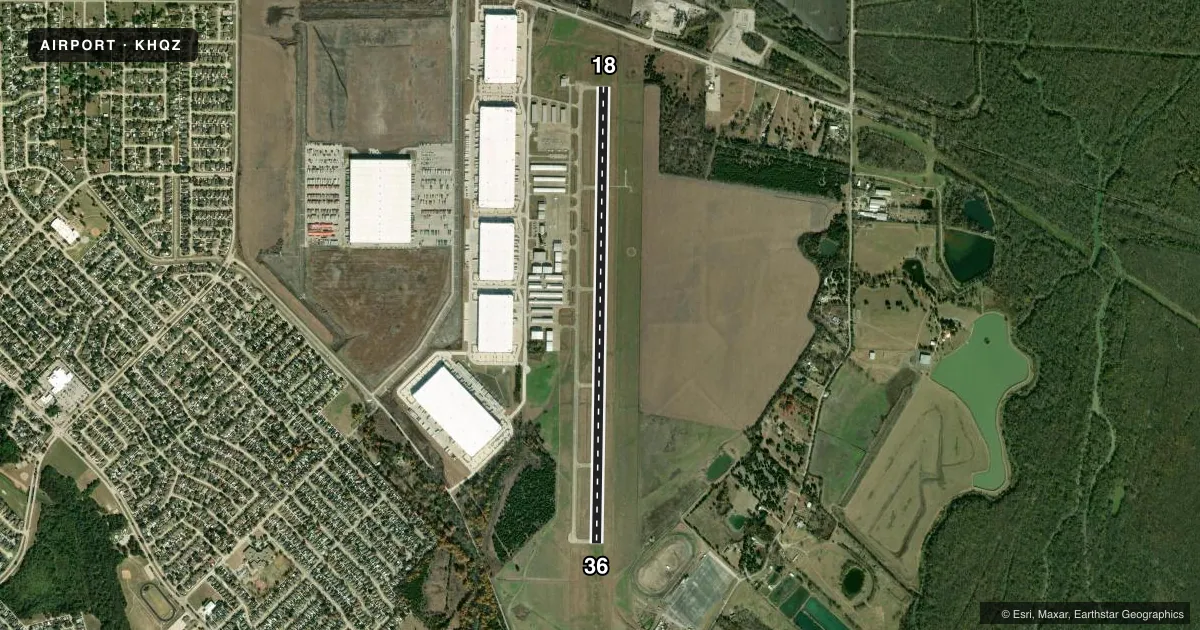
Runways & pattern
Full pagePattern entry · RWY 18
LEFT TRAFFICRunway end performance
| End | TORA | TODA | ASDA | LDA | VGSI | Approach lights | Obstruction |
|---|---|---|---|---|---|---|---|
| 18 | — | — | — | — | PAPI 4-box left(3°) | RLLS | 40', tree, 800' from thr, 460' R of cntrln, slope 15 |
| 36 | — | — | — | — | PAPI 4-box left(3°) | RLLS | 8', fence, 230' from thr, 510' R of cntrln, slope 3 |
Declared distances in feet. TORA = takeoff run available, TODA = takeoff distance, ASDA = accelerate-stop, LDA = landing distance.
Airport sketch
Runways drawn to scale from FAA survey coordinates, rendered over satellite imagery. Not for navigation.
Approaches & charts
Services on the field
Fuel grades, oxygen, maintenance, ramp storage and lighting — as declared to the FAA by the airport operator.
Fuel & services
- Fuel
- 100LLA1+
- Oxygen (bottled)
- Not available
- Oxygen (bulk)
- High pressure
- Airframe repair
- Major
- Power plant repair
- Major
- Other services
- INSTR,RNTL,SALES
Ramp & ground
- Transient storage
- Tie-down
- Hangar
- Landing fee
- No fee published
- Customs
- Not available
- Lighting schedule
- SEE RMK
- Beacon schedule
- SS-SR
- Beacon
- White / Green (civil land)(WG)
- Wind indicator
- Lighted
- Segmented circle
- Yes
Fuel & FBOs
Cheapest 100LL and Jet A on the field and nearby. Always confirm with the FBO before taxi.
Airport notes
Surface conditions, obstructions, local procedures, lighting outages and other notes published with each FAA cycle.
General notes
- BIRDS, COYOTES, & WILD HOGS ON & INVOF ARPT.
- FOR CD WHEN ATCT IS CLSD CTC LONE STAR APCH AT 972-615-2799.
Lighting notes
- MIRL RWY 18/36 PRESET LOW INTST; TO INCR INTST AND TO ACTVT RLLS RWY 18 & 36; REIL RWY 18 & 36; PAPI RWY 18 & 36 - CTAF.
Fuel notes
- 100LLSELF-SERVE FUEL AVBL 24 HRS. FULL SERVE DURG ATNDD HRS, ALSO AVBL AFT HRS CALL 214-244-1959. CALL IN FEE.
Approach & departure obstructions
- 1815 FT BRUSH 199 FT DSTC, 490 FT L.
Other notes
- 1FOR ATTENDANT AFT HRS CALL 214-244-1959.
- MANAGERSBEAVER@CITYOFMESQUITE.COM
VFR map & nearby airports
VFR sectional. Tap any ICAO chip to open that airport.
Key facts · KHQZ
Answer card- ICAO
- KHQZ
- Name
- MESQUITE METRO
- Location
- MESQUITE, TEXAS
- Elevation
- 446.5 ft MSL
- Traffic pattern altitude
- 1,446.5 ft MSL (1,000 AGL)
- Control tower
- Towered · 0700-2100
- Total runways
- 1
- Longest runway
- 18/36 · 6,000 ft
- Published ILS approaches
- 0
- Published frequencies
- 6
- Magnetic variation
- 3°
- Current flight rules
- VFR
- Current wind
- 170° at 4 kt
- Favored runway now
- RWY 18
Mesquite Metro Airport sits in Mesquite, Texas. Field elevation is 446.5 ft MSL. The airport has one runway. Runway 18/36 is 6,000 ft long with concrete pavement. The control tower is open from 0700 to 2100. No ILS approaches are published here.
Pattern altitude is not published. Use 1,000 ft AGL for light piston traffic unless local procedures or ATC say otherwise. The field sits under Lone Star approach control. When the tower is closed, clearance delivery is handled through Lone Star Approach. The runway lighting setup is worth a look before night ops. Medium intensity lights on 18/36 start at low intensity. You use the runway end identifier lights to bring up edge lights and increase intensity. PAPI for 18 and 36 is controlled by CTAF.
Mesquite Executive Air Center is on the field. It carries 100LL and Jet A Prist. Self-serve 100LL is available 24 hours. Full service is available during attended hours. After hours service is available by phone and a call-in fee applies. Watch for brush near runway 18. The published obstruction is 15 ft high, 199 ft from the runway and 490 ft left of centerline. Birds, coyotes and wild hogs are reported in the area, so keep a sharp scan on arrival and departure.