METAR & TAF 1F7
1F7 does not publish a METAR.
Showing the nearest reporting station: KTRL (TERRELL MUNI) · 7.6 NM away. Conditions at 1F7 may differ.
METAR · KTRL
Observed 08:53Z
KTRL 270853Z AUTO 18004KT 10SM CLR 25/22 A2994 RMK AO2 SLP131 T02500217 57007 $
- Wind
- 180° @ 4 kt
- Visibility
- 10 SM
- Temp / Dew
- 25°C / 22°C
- Altimeter
- 29.94 inHg
- Clouds
- CLR
- Density alt
- 1,795 ft
- Ceiling
- Unlimited
- Rules
- VFR
Airport info & contacts
Manager on record, flight service, ARTCC, attendance schedule and pattern altitude — published by the FAA and refreshed every 28 days.
Location
- From city
- 23 NM E
- VFR sectional
- DALLAS-FT WORTH
- ARTCC
- ZFW · FORT WORTH
- NOTAM facility
- FTW (NOTAM-D)
Airport manager
- Name
- HECTOR & LUZ GAMEZ
- Phone
- 214-679-8277
- Address
- 11560 S STATE HWY 205, TERRELL TX 75160
Flight service · Hours
- FSS FTW
- FORT WORTH1-800-WX-BRIEF
- Attendance
- Unattended
Frequencies
Tap any row to copy the frequency to your clipboard.
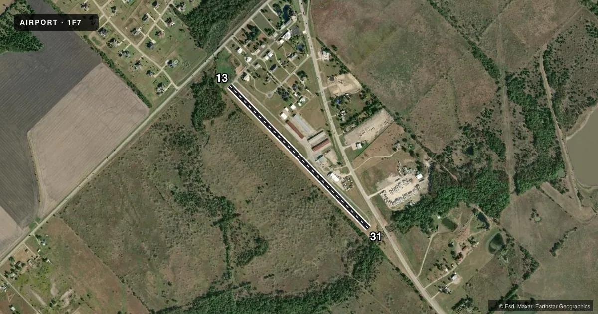
Runways & pattern
Full pagePattern entry · RWY 13
RIGHT TRAFFICRunway end performance
| End | TORA | TODA | ASDA | LDA | VGSI | Approach lights | Obstruction |
|---|---|---|---|---|---|---|---|
| 13 | — | — | — | — | — | — | 35', tree, 201' from thr, 78' R of cntrln, slope 0 |
| 31 | — | — | — | — | — | — | 35', trees, 201' from thr, 78' R of cntrln, slope 0 |
Declared distances in feet. TORA = takeoff run available, TODA = takeoff distance, ASDA = accelerate-stop, LDA = landing distance.
Airport sketch
Runways drawn to scale from FAA survey coordinates, rendered over satellite imagery. Not for navigation.
Approaches & charts
Services on the field
Fuel grades, oxygen, maintenance, ramp storage and lighting — as declared to the FAA by the airport operator.
Fuel & services
- Fuel
- 100LL
- Airframe repair
- Major
- Power plant repair
- Major
Ramp & ground
- Transient storage
- Not published
- Lighting schedule
- SS-SR
- Beacon schedule
- SS-SR
- Beacon
- White / Green (civil land)(WG)
- Wind indicator
- Lighted
- Segmented circle
- No
Fuel & FBOs
Cheapest 100LL and Jet A on the field and nearby. Always confirm with the FBO before taxi.
Airport notes
Surface conditions, obstructions, local procedures, lighting outages and other notes published with each FAA cycle.
General notes
- 4 FT FENCE PARL TO RWY, FULL LEN, 78 FT WEST OF RWY CNTRLN.
- RWY 13/31, 15 FT DROP OFF EACH END.
- RWY AND TWY SHOULDERS BROKEN, LOOSE AGGREGATE & STONES, EXTSV CRACKING AND SPALLING. TWY PVMT ROUGH & UNEVEN.
- RWY 13 APCH EXPECT WIND SHEAR & TURB.
- FOR CD CTC LONE STAR APCH AT 972-615-2799.
Runway surface & condition
- 13/31NSTD FIXTURES
Approach & departure obstructions
- 1330 FT TREES 0-199 FT DSTC, 70 FT RIGHT.
- 3130 FT TREES 0-199 FT DSTC, 78 FT LEFT.
- 13NSTD RWY CL 8 IN WIDE.
- 31NSTD RWY CL 8 IN WIDE.
Other notes
- PRVDD TFC PATS COMPATIBLE WITH PPSD ROCKWALL MUNI ARPT.
- MANAGERHECROR123@GMAIL.COM
- OWNERAIRPARKEAST@GMAIL.COM
VFR map & nearby airports
VFR sectional. Tap any ICAO chip to open that airport.
Key facts · 1F7
Answer card- ICAO
- 1F7
- Name
- AIRPARK EAST
- Location
- DALLAS, TEXAS
- Elevation
- 500 ft MSL
- Traffic pattern altitude
- 1,500 ft MSL (1,000 AGL)
- Control tower
- Non-towered (use CTAF)
- Total runways
- 1
- Longest runway
- 13/31 · 2,630 ft
- Published ILS approaches
- 0
- Published frequencies
- 2
- Magnetic variation
- 6°
- Current flight rules
- VFR
- Current wind
- 180° at 4 kt
- Favored runway now
- RWY 13
AIRPARK EAST is in Dallas, Texas. Field elevation is 500 ft MSL. This is a single-runway field with runway 13/31 at 2,630 ft asphalt, so plan for a short strip. There is no control tower. CTAF and UNICOM are both 122.7. No ILS approaches are published here.
Pattern altitude is not published. Use the standard 1,000 ft AGL pattern unless the current FAA Chart Supplement says otherwise. That puts the light piston pattern at about 1,500 ft MSL based on the field elevation. The published remarks matter here. There are trees close to both ends of the runway. Runway 13 also has wind shear and turbulence noted on approach. The runway and taxiway shoulders are broken in places. Loose aggregate, cracking, spalling and rough taxiway pavement are also noted. Both runway ends have a 15-foot drop-off. Runway 13/31 also has nonstandard fixtures.
No on-field FBOs are listed. Contact the airport operator directly before arrival, or call the field on CTAF or UNICOM for current FBO availability. For clearance delivery, the published remarks direct pilots to Lone Star Approach at 972-615-2799. If you are coming in for the first time, brief the short runway, the close-in trees and the rough pavement before you launch.