METAR & TAF T14
T14 does not publish a METAR.
Showing the nearest reporting station: KGVT (MAJORS) · 7.1 NM away. Conditions at T14 may differ.
METAR · KGVT
Observed 18:10Z
KGVT 261810Z AUTO 21003KT 10SM CLR 35/20 A3002 RMK AO2
- Wind
- 210° @ 3 kt
- Visibility
- 10 SM
- Temp / Dew
- 35°C / 20°C
- Altimeter
- 30.02 inHg
- Clouds
- CLR
- Density alt
- 2,863 ft
- Ceiling
- Unlimited
- Rules
- VFR
Airport info & contacts
Manager on record, flight service, ARTCC, attendance schedule and pattern altitude — published by the FAA and refreshed every 28 days.
Location
- From city
- 3 NM NE
- VFR sectional
- DALLAS-FT WORTH
- ARTCC
- ZFW · FORT WORTH
- NOTAM facility
- FTW (NOTAM-D)
Airport manager
- Name
- CHRIS BYRD
- Phone
- 214-335-4768
- Address
- 325 CO RD 3505, QUINLAN TX 75474
Flight service · Hours
- FSS FTW
- FORT WORTH1-800-WX-BRIEF
- Attendance
- INTMNT
Frequencies
Tap any row to copy the frequency to your clipboard.
Runways & pattern
Full pagePattern entry · RWY 18
LEFT TRAFFICRunway end performance
| End | TORA | TODA | ASDA | LDA | VGSI | Approach lights | Obstruction |
|---|---|---|---|---|---|---|---|
| 18 | — | — | — | — | — | — | 20', trees, 0' from thr, 64' R of cntrln, slope 0 |
| 36 | — | — | — | — | — | — | 10', brush, 0' from thr, 87' R of cntrln, slope 0 |
Declared distances in feet. TORA = takeoff run available, TODA = takeoff distance, ASDA = accelerate-stop, LDA = landing distance.
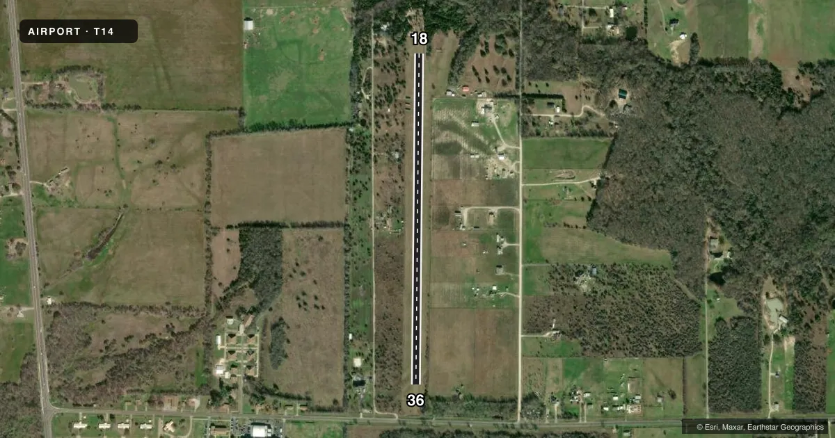
Airport sketch
Runways drawn to scale from FAA survey coordinates, rendered over satellite imagery. Not for navigation.
Approaches & charts
Services on the field
Fuel grades, oxygen, maintenance, ramp storage and lighting — as declared to the FAA by the airport operator.
Fuel & services
- Fuel
- Not available
Ramp & ground
- Transient storage
- Not published
- Lighting schedule
- SS-SR
- Beacon schedule
- SS-SR
- Beacon
- White / Green (civil land)(WG)
- Wind indicator
- Yes
- Segmented circle
- No
Fuel & FBOs
Cheapest 100LL and Jet A on the field and nearby. Always confirm with the FBO before taxi.
Airport notes
Surface conditions, obstructions, local procedures, lighting outages and other notes published with each FAA cycle.
General notes
- RWY SOFT WHEN WET. CALL TO CONFIRM COND.
- RWY SOFT 10 FT ALG BOTH EDGES, FULL LEN.
- FOR CD CTC FORT WORTH ARTCC AT 817-858-7584.
- 12 FT BRUSH, 90 FT EACH SIDE OF RWY CNTRLN.
- STORAGE CONTAINERS ALONG RWY EDGE, NORTH END, WEST SIDE.
Runway surface & condition
- 18/36SOLAR POWERED LIRL.
Approach & departure obstructions
- 18RWY MKD WITH YELLOW CONES.
- 18ALSO, NMRS 20-30 FT TREES IN THE APCH.
VFR map & nearby airports
VFR sectional. Tap any ICAO chip to open that airport.
Key facts · T14
Answer card- ICAO
- T14
- Name
- ROCKIN M
- Location
- QUINLAN, TEXAS
- Elevation
- 473 ft MSL
- Traffic pattern altitude
- 1,473 ft MSL (1,000 AGL)
- Control tower
- Non-towered (use CTAF)
- Total runways
- 1
- Longest runway
- 18/36 · 3,120 ft
- Published ILS approaches
- 0
- Published frequencies
- 1
- Magnetic variation
- 6°
- Current flight rules
- VFR
- Current wind
- 210° at 3 kt
- Favored runway now
- RWY 18
ROCKIN M is in Quinlan, Texas. Field elevation is 473 ft MSL. It has one runway, 18/36, which is 3,120 ft of turf. The airport is non-towered. CTAF is 122.9. No ILS approaches are published.
Pattern altitude is not published. Use 1,000 ft AGL as the standard light piston pattern unless the current FAA Chart Supplement says otherwise. The runway has solar powered low intensity lighting. Runway 18 is marked with yellow cones. That helps on the ground. The field has several items that matter on short final. There are numerous 20 to 30 ft trees in the approach. There are also storage containers along the runway edge at the north end on the west side.
This is a turf strip, so surface condition matters. The runway is soft when wet. The runway is also soft 10 ft along both edges for the full length. Call to confirm condition before you go. There are no on-field FBOs listed, so plan fuel and services with the airport operator or by calling ahead. For clearance delivery, contact Fort Worth ARTCC at 817-858-7584. If you are planning a first arrival, brief the trees, the soft edges and the lighting before you launch.