METAR & TAF 76F
76F does not publish a METAR.
Showing the nearest reporting station: KTRL (TERRELL MUNI) · 14.4 NM away. Conditions at 76F may differ.
METAR · KTRL
Observed 03:53Z
KTRL 270353Z AUTO 17005KT 10SM CLR 28/21 A2995 RMK AO2 SLP135 T02830206 $
- Wind
- 170° @ 5 kt
- Visibility
- 10 SM
- Temp / Dew
- 28°C / 21°C
- Altimeter
- 29.95 inHg
- Clouds
- CLR
- Density alt
- 2,170 ft
- Ceiling
- Unlimited
- Rules
- VFR
Airport info & contacts
Manager on record, flight service, ARTCC, attendance schedule and pattern altitude — published by the FAA and refreshed every 28 days.
Location
- From city
- 3 NM SE
- VFR sectional
- DALLAS-FT WORTH
- ARTCC
- ZFW · FORT WORTH
- NOTAM facility
- FTW (NOTAM-D)
Airport manager
- Name
- PAM PEARSON
- Phone
- 903-873-3381
- Address
- PO BOX 217, WILLS POINT TX 75169
Flight service · Hours
- FSS FTW
- FORT WORTH1-800-WX-BRIEF
- Attendance
- MON-FRI · 0800-1700
Frequencies
Tap any row to copy the frequency to your clipboard.
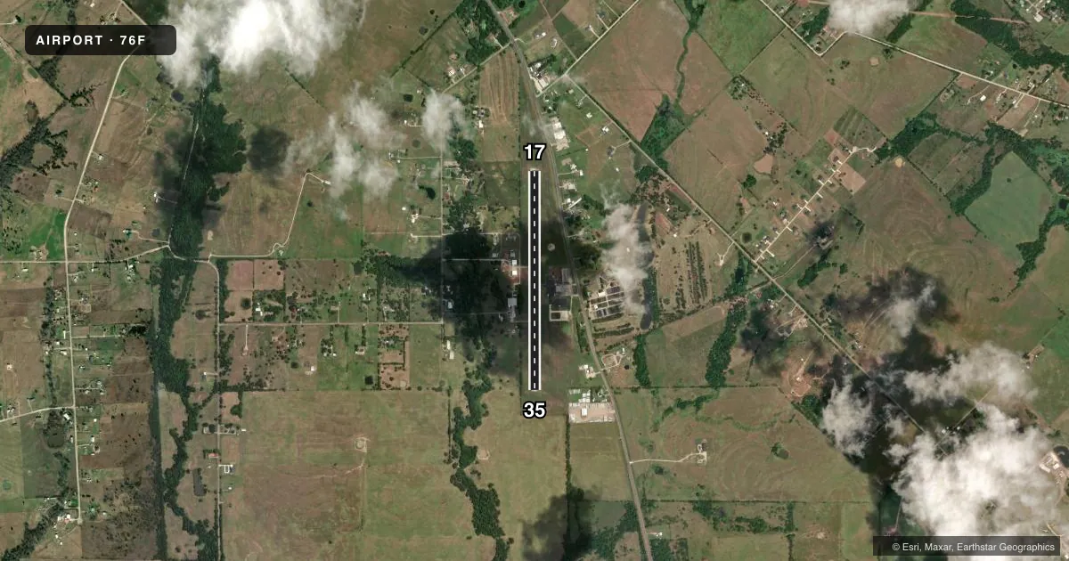
Runways & pattern
Full pagePattern entry · RWY 17
LEFT TRAFFICRunway end performance
| End | TORA | TODA | ASDA | LDA | VGSI | Approach lights | Obstruction |
|---|---|---|---|---|---|---|---|
| 17 | — | — | — | — | — | — | 38', tree, 900' from thr, 165' R of cntrln, slope 18 |
| 35 | — | — | — | — | — | — | 22', trees, 425' from thr, 125' R of cntrln, slope 10 |
Declared distances in feet. TORA = takeoff run available, TODA = takeoff distance, ASDA = accelerate-stop, LDA = landing distance.
Airport sketch
Runways drawn to scale from FAA survey coordinates, rendered over satellite imagery. Not for navigation.
Approaches & charts
Services on the field
Fuel grades, oxygen, maintenance, ramp storage and lighting — as declared to the FAA by the airport operator.
Fuel & services
- Fuel
- 100LL
- Oxygen (bottled)
- Not available
- Oxygen (bulk)
- Not available
- Airframe repair
- Minor
- Power plant repair
- Minor
Ramp & ground
- Transient storage
- Tie-down
- Landing fee
- No fee published
- Customs
- Not available
- Beacon schedule
- SS-SR
- Beacon
- White / Green (civil land)(WG)
- Wind indicator
- Lighted
- Segmented circle
- Yes
Fuel & FBOs
Cheapest 100LL and Jet A on the field and nearby. Always confirm with the FBO before taxi.
Airport notes
Surface conditions, obstructions, local procedures, lighting outages and other notes published with each FAA cycle.
General notes
- 68 FT ANTENNA 810 FT EAST OF RWY CNTRLN.
- FOR CD CTC FORT WORTH ARTCC AT 817-858-7584.
- 24 HR PILOT ACES TO LOUNGE.
Fuel notes
- 100LLSELF SERVE 24 HRS.
Other notes
- MANAGERARPT PHYSICAL ADDRESS: 36671 STATE HWY 64.
- MANAGERWILLS POINT EDC
VFR map & nearby airports
VFR sectional. Tap any ICAO chip to open that airport.
Key facts · 76F
Answer card- ICAO
- 76F
- Name
- VAN ZANDT COUNTY RGNL
- Location
- WILLS POINT, TEXAS
- Elevation
- 522 ft MSL
- Traffic pattern altitude
- 1,522 ft MSL (1,000 AGL)
- Control tower
- Non-towered (use CTAF)
- Total runways
- 1
- Longest runway
- 17/35 · 3,230 ft
- Published ILS approaches
- 0
- Published frequencies
- 2
- Magnetic variation
- 6°
- Current flight rules
- VFR
- Current wind
- 170° at 5 kt
- Favored runway now
- RWY 17
Van Zandt County Rgnl is in Wills Point, Texas. The field elevation is 522 ft MSL. It has one runway, 17/35, which is 3,230 ft long and asphalt. There is no control tower. CTAF and UNICOM are both 122.725. No ILS approaches are published here.
The pattern altitude is not published. Use 1,000 ft AGL for light piston operations unless the current Chart Supplement says otherwise. That puts the standard pattern at 1,522 ft MSL based on the field elevation. The airport has 24-hour self-serve 100LL fuel. The lounge is also available 24 hours. No on-field FBOs are listed, so call the airport operator or the field directly if you need current service details before arrival.
A published remark notes a 68-foot antenna about 810 feet east of the runway centerline. Keep that in mind on departure and arrival. The airport manager is Wills Point EDC. For clearance delivery, contact Fort Worth ARTCC at 817-858-7584. If you are planning a night or IFR arrival, verify current procedures in the Chart Supplement before you go. The runway is modest in length. Performance planning matters, especially on hot Texas days.