METAR & TAF F44
Current METAR
Observed 05:55Z
KF44 270555Z AUTO 00000KT 10SM CLR 24/21 A2997 RMK AO2
- Wind
- 000° @ 0 kt
- Visibility
- 10 SM
- Temp / Dew
- 24°C / 21°C
- Altimeter
- 29.97 inHg
- Clouds
- CLR
- Density alt
- 1,569 ft
- Ceiling
- Unlimited
- Rules
- VFR
Airport info & contacts
Manager on record, flight service, ARTCC, attendance schedule and pattern altitude — published by the FAA and refreshed every 28 days.
Location
- From city
- 3 NM SE
- VFR sectional
- DALLAS-FT WORTH
- ARTCC
- ZFW · FORT WORTH
- NOTAM facility
- FTW (NOTAM-D)
Airport manager
- Name
- SHANNON EASLEY
- Phone
- 903-675-8036
- Address
- 508 E. TYLER ST., ATHENS TX 75751
Flight service · Hours
- FSS FTW
- FORT WORTH1-800-WX-BRIEF
- Attendance
- 0800-DUSK
Frequencies
Tap any row to copy the frequency to your clipboard.
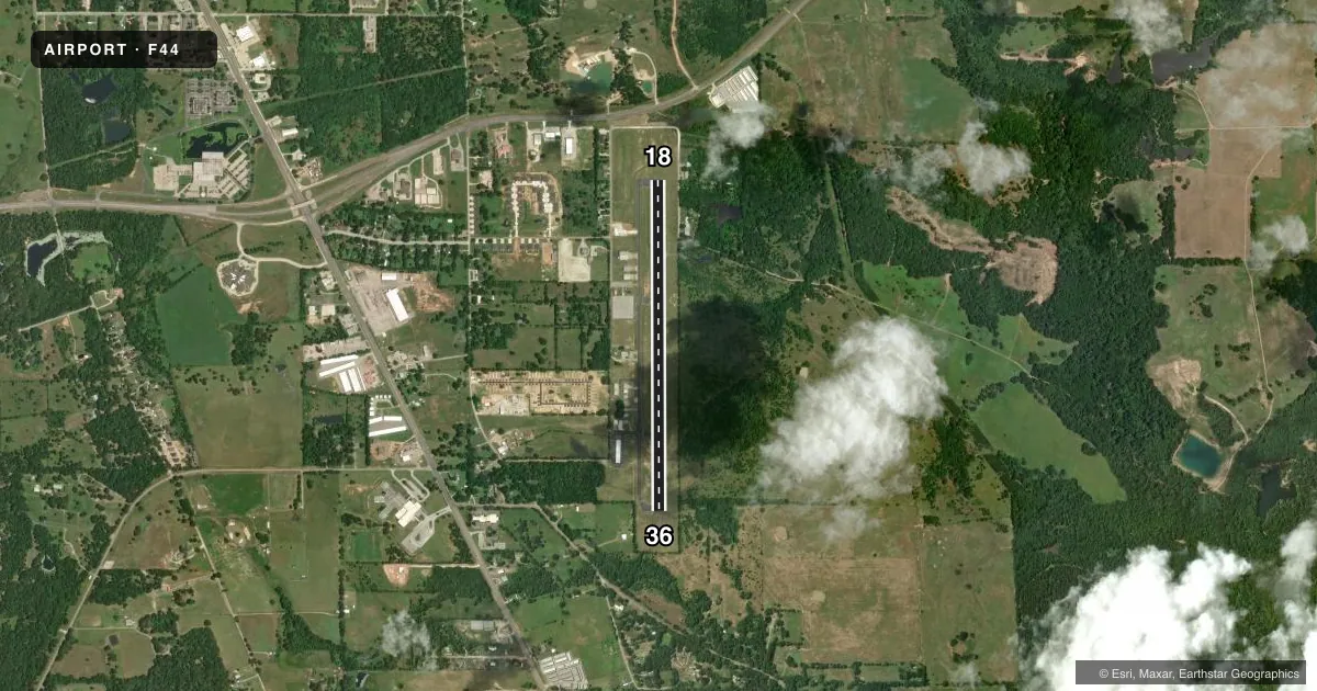
Runways & pattern
Full pagePattern entry · RWY 18
LEFT TRAFFICRunway end performance
| End | TORA | TODA | ASDA | LDA | VGSI | Approach lights | Obstruction |
|---|---|---|---|---|---|---|---|
| 18 | — | — | — | — | PAPI 2-box left(3°) | — | 66', trees, 985' from thr, 160' R of cntrln, slope 11 |
| 36 | — | — | — | — | PAPI 2-box left(4°) | — | 55', trees, 700' from thr, 305' R of cntrln, slope 9 |
Declared distances in feet. TORA = takeoff run available, TODA = takeoff distance, ASDA = accelerate-stop, LDA = landing distance.
Airport sketch
Runways drawn to scale from FAA survey coordinates, rendered over satellite imagery. Not for navigation.
Approaches & charts
Services on the field
Fuel grades, oxygen, maintenance, ramp storage and lighting — as declared to the FAA by the airport operator.
Fuel & services
- Fuel
- 100LLA
- Oxygen (bottled)
- HIGH/LOW
- Oxygen (bulk)
- Not available
- Airframe repair
- Major
- Power plant repair
- Major
- Other services
- INSTR,RNTL,SALES
Ramp & ground
- Transient storage
- Tie-down
- Hangar
- Landing fee
- No fee published
- Customs
- Not available
- Lighting schedule
- SS-SR
- Beacon schedule
- SS-SR
- Beacon
- White / Green (civil land)(WG)
- Wind indicator
- Lighted
- Segmented circle
- Yes
Fuel & FBOs
Cheapest 100LL and Jet A on the field and nearby. Always confirm with the FBO before taxi.
Airport notes
Surface conditions, obstructions, local procedures, lighting outages and other notes published with each FAA cycle.
General notes
- FERAL HOGS ON AND INVOF ARPT.
- FOR CD CTC FORT WORTH ARTCC AT 817-858-7584.
Approach & departure obstructions
- 1811 FT ROAD 160 FT DSTC, 235 FT L.
- 3612-25 FT TREES ON FENCELINE 0-200 FT DSTC, 247 R.
- 18ALSO 15 FT RD AT 160 DSTC, 235 L, 0:1.
Other notes
- THIS AIRPORT HAS BEEN SURVEYED BY THE NATIONAL GEODETIC SURVEY.
- MANAGERPUBLIC WORKS DIRECTOR.
VFR map & nearby airports
VFR sectional. Tap any ICAO chip to open that airport.
Key facts · F44
Answer card- ICAO
- F44
- Name
- ATHENS MUNI
- Location
- ATHENS, TEXAS
- Elevation
- 444.1 ft MSL
- Traffic pattern altitude
- 1,444.1 ft MSL (1,000 AGL)
- Control tower
- Non-towered (use CTAF)
- Total runways
- 1
- Longest runway
- 18/36 · 3,988 ft
- Published ILS approaches
- 0
- Published frequencies
- 2
- Magnetic variation
- 2°
- Current flight rules
- VFR
- Current wind
- 000° at 0 kt
- Favored runway now
- –
Athens Muni sits in Athens, Texas. The field elevation is 444.1 ft MSL. It has one runway, 18/36, which is 3,988 ft long and asphalt. This is an uncontrolled airport with no tower. CTAF is 123.0 and UNICOM is 123.0.
No ILS approaches are published here. Pattern altitude is not published, so use the standard 1,000 ft AGL for light piston operations unless the current Chart Supplement says otherwise. The airport has two on-field FBOs. Dyson Aviation carries 100LL and Jet A. Addco Aviation Services also carries 100LL and Jet A. Call ahead if you need current service details.
Published remarks matter here. Trees sit near the runway 36 side of the fence line. There are also road obstructions near runway 18. Feral hogs are reported on and near the airport, so keep an eye out on taxi and takeoff. For clearance delivery, contact Fort Worth ARTCC at 817-858-7584. The airport is in a part of Texas where density altitude can matter in warm weather. Plan performance with that in mind. If you are unfamiliar with the field, review the current Chart Supplement before departure.