METAR & TAF KPSN
Current METAR
Observed 13:15Z
KPSN 271315Z AUTO 19005KT 1 3/4SM -RA BR CLR 26/24 A3000 RMK AO2 VIS 1/4V5
- Wind
- 190° @ 5 kt
- Visibility
- 0.75 SM
- Temp / Dew
- 26°C / 24°C
- Altimeter
- 30.00 inHg
- Clouds
- CLR
- Density alt
- 1,745 ft
- Ceiling
- Unlimited
- Rules
- LIFR
Airport info & contacts
Manager on record, flight service, ARTCC, attendance schedule and pattern altitude — published by the FAA and refreshed every 28 days.
Location
- From city
- 4 NM NW
- VFR sectional
- HOUSTON
- ARTCC
- ZFW · FORT WORTH
- NOTAM facility
- PSN (NOTAM-D)
Airport manager
- Name
- TERESA HERRERA
- Phone
- 903-731-8415
- Address
- 504 N. QUEEN, PALESTINE TX 75801
Flight service · Hours
- FSS FTW
- FORT WORTH1-800-WX-BRIEF
- Attendance
- 0800-1700
Frequencies
Tap any row to copy the frequency to your clipboard.
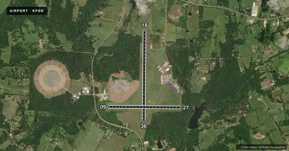
Runways & pattern
Full pagePattern entry · RWY 18
LEFT TRAFFIC| Runway | Heading (°M) | Length | Surface | Traffic |
|---|---|---|---|---|
| 18/36Favored | 177° / 357° | 5,005 ft | ASPH | Standard L |
| 09/27 | 87° / 267° | 4,002 ft | ASPH | Standard L |
Runway end performance
| End | TORA | TODA | ASDA | LDA | VGSI | Approach lights | Obstruction |
|---|---|---|---|---|---|---|---|
| 18 | — | — | — | — | PAPI 4-box left(3°) | — | 50', tree, 750' from thr, 276' R of cntrln, slope 11 |
| 36 | — | — | — | — | PAPI 4-box left(3°) | — | 32', trees, 672' from thr, 155' R of cntrln, slope 14 |
| 09 | — | — | — | — | — | — | 56', trees, 856' from thr, 0' R of cntrln, slope 11 |
| 27 | — | — | — | — | — | — | 35', trees, 201' from thr, 200' R of cntrln, slope 1 |
Declared distances in feet. TORA = takeoff run available, TODA = takeoff distance, ASDA = accelerate-stop, LDA = landing distance.
Airport sketch
Runways drawn to scale from FAA survey coordinates, rendered over satellite imagery. Not for navigation.
Approaches & charts
Services on the field
Fuel grades, oxygen, maintenance, ramp storage and lighting — as declared to the FAA by the airport operator.
Fuel & services
- Fuel
- 100LLA
- Oxygen (bottled)
- Not available
- Oxygen (bulk)
- Not available
- Other services
- INSTR,SALES
Ramp & ground
- Transient storage
- Tie-down
- Hangar
- Landing fee
- No fee published
- Customs
- Not available
- Lighting schedule
- SEE RMK
- Beacon schedule
- SS-SR
- Beacon
- White / Green (civil land)(WG)
- Wind indicator
- Lighted
- Segmented circle
- Yes
Fuel & FBOs
Cheapest 100LL and Jet A on the field and nearby. Always confirm with the FBO before taxi.
Airport notes
Surface conditions, obstructions, local procedures, lighting outages and other notes published with each FAA cycle.
General notes
- FOR CD CTC FORT WORTH ARTCC AT 817-858-7584.
- RWY 09/27 CLSD DAILY SS-SR, PERM.
Lighting notes
- MIRL RWY 18/36 PRESET LOW INTST DUSK-DAWN; TO INCR INTST ACTVT - CTAF.
Approach & departure obstructions
- 0915 FT BRUSH 160 FT DSTC, 234 R.
- 2725 FT TREES 120-200 FT DSTC, 249 FT L/R
- 3610 BRUSH 90 FT DSTC, 245 R.
- 36REIL OTS INDEFLY.
Other notes
- EXISTED PRIOR TO 1959.
- 2FOR SVC AFT HRS CALL 903-724-2225. CALL-IN FEE.
- MANAGERCITY/ARPT MGR
VFR map & nearby airports
VFR sectional. Tap any ICAO chip to open that airport.
Key facts · KPSN
Answer card- ICAO
- KPSN
- Name
- PALESTINE MUNI
- Location
- PALESTINE, TEXAS
- Elevation
- 422.6 ft MSL
- Traffic pattern altitude
- 1,422.6 ft MSL (1,000 AGL)
- Control tower
- Non-towered (use CTAF)
- Total runways
- 2
- Longest runway
- 18/36 · 5,005 ft
- Published ILS approaches
- 0
- Published frequencies
- 2
- Magnetic variation
- 4°
- Current flight rules
- LIFR
- Current wind
- 190° at 5 kt
- Favored runway now
- RWY 18
Palestine Muni is in Palestine, Texas. Field elevation is 422.6 ft MSL. The airport has two asphalt runways. The longest is 5,005 ft on runway 18/36. There is no control tower. CTAF and UNICOM are both 122.7. No ILS approaches are published here.
Pattern altitude is not published. Use the standard 1,000 ft AGL for light piston traffic unless the current Chart Supplement says otherwise. That puts the pattern at about 1,423 ft MSL based on the field elevation. Verify before you fly. The field has one on-field FBO. Palestine Jet Center carries 100LL and Jet A. Call (903) 723-0111 for current service details.
A few operational items matter here. Runway 09/27 is permanently closed from sunset to sunrise. The runway 18/36 lights are preset to low intensity from dusk to dawn. Use CTAF to increase intensity. Runway end identifier lights for runway 36 are out of service indefinitely. There are also brush and tree obstructions near the runway ends, so plan your takeoff and landing with that in mind. For clearance delivery, contact Fort Worth ARTCC. If you need after-hours service, the published number is 903-724-2225. A call-in fee applies.