METAR & TAF 68F
68F does not publish a METAR.
Showing the nearest reporting station: KLXY (MEXIA-LIMESTONE COUNTY) · 10.5 NM away. Conditions at 68F may differ.
METAR · KLXY
Observed 16:15Z
KLXY 261615Z AUTO 18007KT 10SM CLR 30/19 A3007 RMK AO2 T03030189 TSNO
- Wind
- 180° @ 7 kt
- Visibility
- 10 SM
- Temp / Dew
- 30°C / 19°C
- Altimeter
- 30.07 inHg
- Clouds
- CLR
- Density alt
- 2,265 ft
- Ceiling
- Unlimited
- Rules
- VFR
Airport info & contacts
Manager on record, flight service, ARTCC, attendance schedule and pattern altitude — published by the FAA and refreshed every 28 days.
Location
- From city
- 3 NM NW
- VFR sectional
- HOUSTON
- ARTCC
- ZFW · FORT WORTH
- NOTAM facility
- FTW (NOTAM-D)
Airport manager
- Name
- JACOB COWLING
- Phone
- 254-739-5327
- Address
- 105 S. 4TH AVE., TEAGUE TX 75860
Flight service · Hours
- FSS FTW
- FORT WORTH1-800-WX-BRIEF
- Attendance
- Unattended
Frequencies
Tap any row to copy the frequency to your clipboard.
Runways & pattern
Full pagePattern entry · RWY 15
LEFT TRAFFICRunway end performance
| End | TORA | TODA | ASDA | LDA | VGSI | Approach lights | Obstruction |
|---|---|---|---|---|---|---|---|
| 15 | — | — | — | — | — | — | 42', trees, 404' from thr, 92' R of cntrln, slope 4 |
| 33 | — | — | — | — | — | — | 35', tree, 270' from thr, 125' R of cntrln, slope 2 |
Declared distances in feet. TORA = takeoff run available, TODA = takeoff distance, ASDA = accelerate-stop, LDA = landing distance.
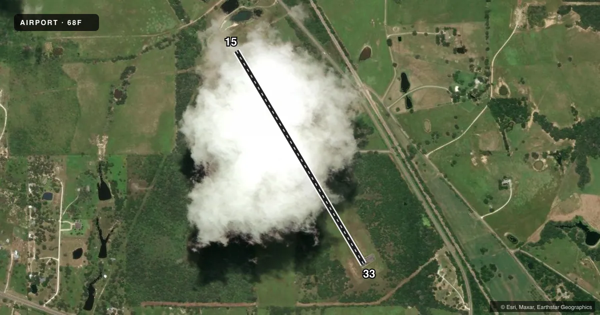
Airport sketch
Runways drawn to scale from FAA survey coordinates, rendered over satellite imagery. Not for navigation.
Approaches & charts
Services on the field
Fuel grades, oxygen, maintenance, ramp storage and lighting — as declared to the FAA by the airport operator.
Fuel & services
- Fuel
- Not available
- Oxygen (bulk)
- Not available
Ramp & ground
- Transient storage
- Tie-down
- Landing fee
- No fee published
- Customs
- Not available
- Lighting schedule
- SS-SR
- Beacon schedule
- SS-SR
- Beacon
- White / Green (civil land)(WG)
- Wind indicator
- Lighted
- Segmented circle
- Yes
Fuel & FBOs
Cheapest 100LL and Jet A on the field and nearby. Always confirm with the FBO before taxi.
Airport notes
Surface conditions, obstructions, local procedures, lighting outages and other notes published with each FAA cycle.
General notes
- MOWING OPNS ON ARPT SUMMER MONTHS.
- FOR ACCESS GATE CALL CITY HALL 254-739-2547 0800-1700; AFT HRS CALL POLICE 254-739-2553 OR 903-389-3236.
- RADIO CONTROL ACFT OPER ON RAMP EAST OF RWY 15/33.
- FOR CD CTC FORT WORTH ARTCC AT 817-858-7584.
Lighting notes
- BEACON OTS.
Runway surface & condition
- 15/33NMRS RWY LGTS OTS.
Approach & departure obstructions
- 3310 FT TREES 195 FT DSTC.
- 15MKGS FADED.
- 33NO RWY NR.
Other notes
- MANAGERPUBLIC WORKS DIRECTOR.
VFR map & nearby airports
VFR sectional. Tap any ICAO chip to open that airport.
Key facts · 68F
Answer card- ICAO
- 68F
- Name
- TEAGUE MUNI
- Location
- TEAGUE, TEXAS
- Elevation
- 525 ft MSL
- Traffic pattern altitude
- 1,525 ft MSL (1,000 AGL)
- Control tower
- Non-towered (use CTAF)
- Total runways
- 1
- Longest runway
- 15/33 · 3,300 ft
- Published ILS approaches
- 0
- Published frequencies
- 1
- Magnetic variation
- 6°
- Current flight rules
- VFR
- Current wind
- 180° at 7 kt
- Favored runway now
- RWY 15
Teague Muni sits in Teague, Texas at 525 ft MSL. It has one runway, 15/33, which is 3,300 ft of asphalt. The field is non-towered. CTAF is 122.9. No ILS approaches are published here.
Pattern altitude is not published in the facts. Use the current FAA Chart Supplement before you fly in. Runway 15/33 lights are out of service. Runway 15 markings are faded. Runway 33 has no runway numbers. There are 10 ft trees about 195 ft from runway 33. The beacon is also out of service. Mowing takes place during the summer months, so expect airport activity on the field.
There are no on-field FBOs listed. Check with the airport operator or the FBO directly by phone before arrival for current services. Radio controlled aircraft operate on the ramp east of runway 15/33, so keep an eye out for that area during taxi and runup. For access, call City Hall at 254-739-2547 between 0800 and 1700. After hours, call police at 254-739-2553 or 903-389-3236. Clearance delivery is handled through Fort Worth ARTCC at 817-858-7584. The airport manager is the Public Works Director.