METAR & TAF T15
T15 does not publish a METAR.
Showing the nearest reporting station: KCNW (TSTC WACO) · 21.2 NM away. Conditions at T15 may differ.
METAR · KCNW
Observed 01:55Z
KCNW 270155Z 15006KT 10SM CLR 31/18 A2994
- Wind
- 150° @ 6 kt
- Visibility
- 10 SM
- Temp / Dew
- 31°C / 18°C
- Altimeter
- 29.94 inHg
- Clouds
- CLR
- Density alt
- 2,404 ft
- Ceiling
- Unlimited
- Rules
- VFR
Airport info & contacts
Manager on record, flight service, ARTCC, attendance schedule and pattern altitude — published by the FAA and refreshed every 28 days.
Location
- From city
- 3 NM NE
- VFR sectional
- HOUSTON
- ARTCC
- ZFW · FORT WORTH
- NOTAM facility
- FTW (NOTAM-D)
Airport manager
- Name
- LAVONNE LAPREZE
- Phone
- 254-275-0051
- Address
- 101 FORTUNE STREET, PO BOX 980, MARLIN TX 76661
Flight service · Hours
- FSS FTW
- FORT WORTH1-800-WX-BRIEF
- Attendance
- Unattended
Frequencies
Tap any row to copy the frequency to your clipboard.
Runways & pattern
Full pagePattern entry · RWY 17
LEFT TRAFFICRunway end performance
| End | TORA | TODA | ASDA | LDA | VGSI | Approach lights | Obstruction |
|---|---|---|---|---|---|---|---|
| 17 | — | — | — | — | — | — | 32', trees, 650' from thr, 130' R of cntrln, slope 14 |
| 35 | — | — | — | — | — | — | 8', fence, 201' from thr, 75' R of cntrln, slope 0 |
Declared distances in feet. TORA = takeoff run available, TODA = takeoff distance, ASDA = accelerate-stop, LDA = landing distance.
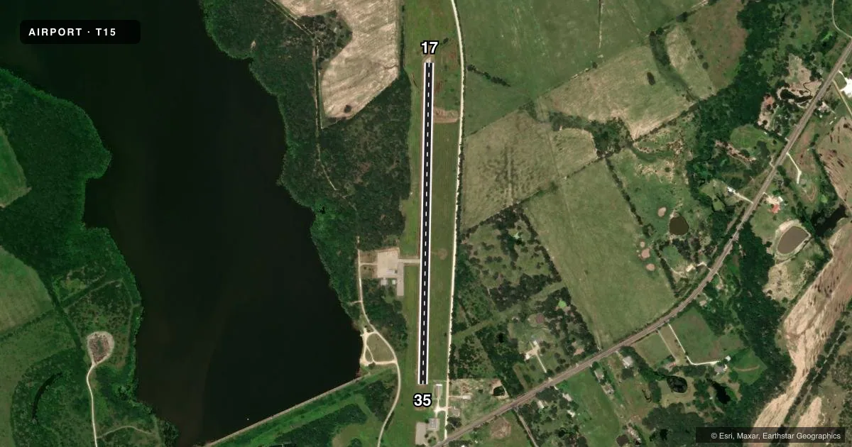
Airport sketch
Runways drawn to scale from FAA survey coordinates, rendered over satellite imagery. Not for navigation.
Approaches & charts
Services on the field
Fuel grades, oxygen, maintenance, ramp storage and lighting — as declared to the FAA by the airport operator.
Fuel & services
- Fuel
- Not available
- Oxygen (bottled)
- Not available
- Oxygen (bulk)
- Not available
- Airframe repair
- Not available
- Power plant repair
- Not available
Ramp & ground
- Transient storage
- Tie-down
- Landing fee
- No fee published
- Customs
- Not available
- Wind indicator
- Yes
- Segmented circle
- Yes
Fuel & FBOs
Cheapest 100LL and Jet A on the field and nearby. Always confirm with the FBO before taxi.
Airport notes
Surface conditions, obstructions, local procedures, lighting outages and other notes published with each FAA cycle.
General notes
- FOR CD CTC FORT WORTH ARTCC AT 817-858-7584.
- ARPT DAY VFR ONLY. NO LIGHTS.
Approach & departure obstructions
- 1720 FT TREE, 126 FT DSTC, 118 L.
- 358 FT FENCE, 0-199 FT DSTC, 70 FT RIGHT.
- 358 FT FENCE, 0-199 FT DSTC, 77 FT R.
Other notes
- THIS AIRPORT HAS BEEN SURVEYED BY THE NATIONAL GEODETIC SURVEY.
- PRE DATES THE ACT.
- WINDSOCK MAY BE UNREL DUE TO TREES IN PROXIMITY AND MAST NOT VER.
- MANAGERPUBLIC WORKS DIRECTOR.
- MANAGEREXT 1004
VFR map & nearby airports
VFR sectional. Tap any ICAO chip to open that airport.
Key facts · T15
Answer card- ICAO
- T15
- Name
- MARLIN
- Location
- MARLIN, TEXAS
- Elevation
- 410.7 ft MSL
- Traffic pattern altitude
- 1,410.7 ft MSL (1,000 AGL)
- Control tower
- Non-towered (use CTAF)
- Total runways
- 1
- Longest runway
- 17/35 · 3,021 ft
- Published ILS approaches
- 0
- Published frequencies
- 3
- Magnetic variation
- 5°
- Current flight rules
- VFR
- Current wind
- 150° at 6 kt
- Favored runway now
- RWY 17
Marlin Airport (T15) sits in Marlin, Texas. The field elevation is 410.7 ft MSL. It has one runway, 17/35, which is 3,021 ft long with asphalt pavement. There is no control tower. No ILS approaches are published. The pattern altitude is not published, so use the standard 1,000 ft AGL for light piston operations unless the current FAA Chart Supplement says otherwise.
This is a day VFR only airport. There are no lights, so plan for daylight arrival and departure only. The published remarks also note that the windsock may be unreliable because of nearby trees and a mast that is not vertical. That matters here because the field also has obstructions near both runway ends. Runway 17 has a 20-foot tree near the approach area. Runway 35 has 8-foot fences close to the runway on the right side.
No on-field FBOs are listed. Contact the airport operator directly before arrival if you need local services. For clearance delivery, Fort Worth ARTCC is listed in the remarks. The airport is surveyed by the National Geodetic Survey. Pilots should also verify current airspace and any local procedures in the FAA Chart Supplement before flying in.