METAR & TAF KTPL
Current METAR
Observed 12:51Z
KTPL 271251Z AUTO 18008KT CLR 25/23 A2999 RMK AO2 SLPNO T02500233 PWINO RVRNO $
- Wind
- 180° @ 8 kt
- Visibility
- —
- Temp / Dew
- 25°C / 23°C
- Altimeter
- 29.99 inHg
- Clouds
- CLR
- Density alt
- 1,959 ft
- Ceiling
- Unlimited
- Rules
- VFR
Airport info & contacts
Manager on record, flight service, ARTCC, attendance schedule and pattern altitude — published by the FAA and refreshed every 28 days.
Location
- From city
- 5 NM NW
- VFR sectional
- SAN ANTONIO
- ARTCC
- ZFW · FORT WORTH
- NOTAM facility
- TPL (NOTAM-D)
Airport manager
- Name
- SEAN PARKER
- Phone
- 254-298-5770
- Address
- 7720-F AIRPORT ROAD, TEMPLE TX 76501
Flight service · Hours
- FSS SJT
- SAN ANGELO1-800-WX-BRIEF
- Attendance
- 0700-2000
Frequencies
Tap any row to copy the frequency to your clipboard.
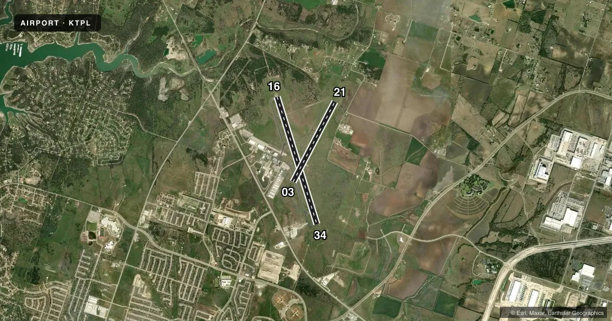
Runways & pattern
Full pagePattern entry · RWY 16
LEFT TRAFFIC| Runway | Heading (°M) | Length | Surface | Traffic |
|---|---|---|---|---|
| 16/34Favored | 160° / 340° | 7,000 ft | ASPH | Standard L |
| 03/21 | 25° / 205° | 4,740 ft | ASPH | Standard L |
Runway end performance
| End | TORA | TODA | ASDA | LDA | VGSI | Approach lights | Obstruction |
|---|---|---|---|---|---|---|---|
| 16 | 7,000' | 7,000' | 7,000' | 7,000' | — | MALSR | — |
| 34 | 7,000' | 7,000' | 7,000' | 7,000' | PAPI 4-box left(3°) | — | — |
| 03 | 4,740' | 4,740' | 4,740' | 4,740' | — | — | — |
| 21 | 4,740' | 4,740' | 4,740' | 4,740' | PAPI 4-box left(3°) | — | — |
Declared distances in feet. TORA = takeoff run available, TODA = takeoff distance, ASDA = accelerate-stop, LDA = landing distance.
Airport sketch
Runways drawn to scale from FAA survey coordinates, rendered over satellite imagery. Not for navigation.
Approaches & charts
ILS · 1
Services on the field
Fuel grades, oxygen, maintenance, ramp storage and lighting — as declared to the FAA by the airport operator.
Fuel & services
- Fuel
- 100LLAA1+
- Oxygen (bottled)
- Not available
- Airframe repair
- Major
- Power plant repair
- Major
- Other services
- AMB,AVNCS,INSTR,RNTL
Ramp & ground
- Transient storage
- Tie-down
- Landing fee
- No fee published
- Customs
- Not available
- Lighting schedule
- SEE RMK
- Beacon schedule
- SS-SR
- Beacon
- White / Green (civil land)(WG)
- Wind indicator
- Lighted
- Segmented circle
- Yes
Fuel & FBOs
Cheapest 100LL and Jet A on the field and nearby. Always confirm with the FBO before taxi.
Airport notes
Surface conditions, obstructions, local procedures, lighting outages and other notes published with each FAA cycle.
General notes
- ARFF NOT AVBL 2000-0700.
- MIL CONTR FUEL AVBL.
- GLDR OPS 1.5 MI NORTH OF RWY 16 THR.
Lighting notes
- DUSK-2200. ACTVT PAPI RWY 21 - CTAF. AFT 2200 MIRL RWY 16/34 PRESET LOW INTST; TO INCR INTST & ACTVT MALSR RWY 16 - CTAF. MIRL RWY 03/21 NOT AVBL AFT 2200.
Fuel notes
- 100LLALL FUELS FULL & SELF SVC.
Other notes
- PRE DATES ACT.
- ARFF PROTECTION MEETS INDEX B.
- 1FOR AFT HRS ATNDT 254-493-8530.
VFR map & nearby airports
VFR sectional. Tap any ICAO chip to open that airport.
Key facts · KTPL
Answer card- ICAO
- KTPL
- Name
- DRAUGHON-MILLER CENTRAL TEXAS RGNL
- Location
- TEMPLE, TEXAS
- Elevation
- 682.3 ft MSL
- Traffic pattern altitude
- 1,682.3 ft MSL (1,000 AGL)
- Control tower
- Non-towered (use CTAF)
- Total runways
- 2
- Longest runway
- 16/34 · 7,000 ft
- Published ILS approaches
- 1
- Published frequencies
- 5
- Magnetic variation
- 3°
- Current flight rules
- VFR
- Current wind
- 180° at 8 kt
- Favored runway now
- RWY 16
Draughon-Miller Central Texas Rgnl sits in Temple, Texas. Field elevation is 682.3 ft MSL. The airport has two asphalt runways. The longest is runway 16/34 at 7,000 ft. Runway 03/21 is 4,740 ft. There is no control tower, so use CTAF 123.0 and UNICOM 123.0 for local traffic calls. One ILS approach is published for runway 16. Pattern altitude is not published, so plan on the standard 1,000 ft AGL for light piston traffic unless the current FAA Chart Supplement says otherwise.
Temple Executive Air Center is on the field. It carries 100LL, Jet A and Jet A Prist. Fuel is self-serve. The published remarks also note that lighting is available from dusk to 2200. After 2200, runway 16/34 lights default to low intensity. Runway 03/21 medium intensity lights are not available after 2200. The PAPI on runway 21 is activated by CTAF. If you need after-hours help, the published remarks list a phone number for the attendant.
For a first-time arrival, pay attention to the lack of tower service and the published lighting limits after 2200. Glider operations are 1.5 miles north of the runway 16 threshold. ARFF is not available from 2000 to 0700. Check the current FAA Chart Supplement for any changes before you go.