METAR & TAF KGOP
Current METAR
Observed 13:15Z
KGOP 271315Z AUTO 17006KT 10SM CLR 26/24 A2999 RMK AO2
- Wind
- 170° @ 6 kt
- Visibility
- 10 SM
- Temp / Dew
- 26°C / 24°C
- Altimeter
- 29.99 inHg
- Clouds
- CLR
- Density alt
- 2,355 ft
- Ceiling
- Unlimited
- Rules
- VFR
Airport info & contacts
Manager on record, flight service, ARTCC, attendance schedule and pattern altitude — published by the FAA and refreshed every 28 days.
Location
- From city
- 3 NM W
- VFR sectional
- SAN ANTONIO
- ARTCC
- ZFW · FORT WORTH
- NOTAM facility
- GOP (NOTAM-D)
Airport manager
- Name
- BRAD HUNT
- Phone
- 254-865-8951
- Address
- 110 N 8TH, GATESVILLE TX 76528
Flight service · Hours
- FSS FTW
- FORT WORTH1-800-WX-BRIEF
- Attendance
- MON-FRI · 0800-1700
Frequencies
Tap any row to copy the frequency to your clipboard.
Runways & pattern
Full pagePattern entry · RWY 17
LEFT TRAFFICRunway end performance
| End | TORA | TODA | ASDA | LDA | VGSI | Approach lights | Obstruction |
|---|---|---|---|---|---|---|---|
| 17 | — | — | — | — | PAPI 2-box left(3°) | — | 35', trees, 355' from thr, 35' R of cntrln, slope 4 |
| 35 | — | — | — | — | PAPI 2-box left(3°) | — | 23', trees, 400' from thr, 40' R of cntrln, slope 8 |
Declared distances in feet. TORA = takeoff run available, TODA = takeoff distance, ASDA = accelerate-stop, LDA = landing distance.
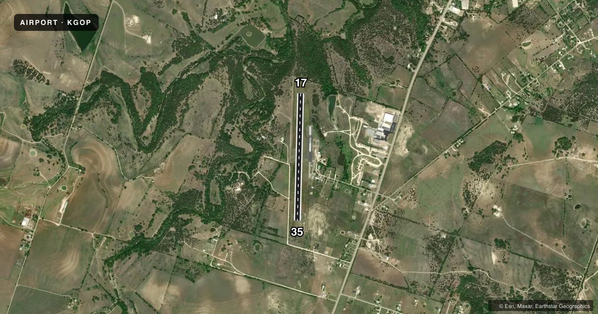
Airport sketch
Runways drawn to scale from FAA survey coordinates, rendered over satellite imagery. Not for navigation.
Approaches & charts
Services on the field
Fuel grades, oxygen, maintenance, ramp storage and lighting — as declared to the FAA by the airport operator.
Fuel & services
- Fuel
- 100LL
- Oxygen (bottled)
- HIGH/LOW
- Oxygen (bulk)
- HIGH/LOW
- Airframe repair
- Major
- Power plant repair
- Major
Ramp & ground
- Transient storage
- Tie-down
- Hangar
- Landing fee
- No fee published
- Customs
- Not available
- Lighting schedule
- SEE RMK
- Beacon schedule
- SS-SR
- Beacon
- White / Green (civil land)(WG)
- Wind indicator
- Yes
- Segmented circle
- Yes
Fuel & FBOs
Cheapest 100LL and Jet A on the field and nearby. Always confirm with the FBO before taxi.
Airport notes
Surface conditions, obstructions, local procedures, lighting outages and other notes published with each FAA cycle.
General notes
- LOW FLYING MIL JET ACFT & HEL IN VCNTY.
- FOR CD CTC FORT WORTH ARTCC AT 817-858-7584.
Lighting notes
- DUSK-DAWN. MIRL RWY 17/35 PRESET LOW INTST, TO INCR INTST ACTVT - CTAF.
Fuel notes
- 100LLFUEL AVBL 24 HRS SELF SERVE.
Approach & departure obstructions
- 35RISING GROUND, 32-199 FT DSTC, 102-125 R.
Other notes
- MANAGERCITY MGR.
VFR map & nearby airports
VFR sectional. Tap any ICAO chip to open that airport.
Key facts · KGOP
Answer card- ICAO
- KGOP
- Name
- GATESVILLE MUNI
- Location
- GATESVILLE, TEXAS
- Elevation
- 905 ft MSL
- Traffic pattern altitude
- 1,905 ft MSL (1,000 AGL)
- Control tower
- Non-towered (use CTAF)
- Total runways
- 1
- Longest runway
- 17/35 · 3,400 ft
- Published ILS approaches
- 0
- Published frequencies
- 1
- Magnetic variation
- 7°
- Current flight rules
- VFR
- Current wind
- 170° at 6 kt
- Favored runway now
- RWY 17
Gatesville Muni sits in Gatesville, Texas. The field elevation is 905 ft MSL. It has one runway. Runway 17/35 is 3,400 ft of asphalt. There is no control tower. CTAF is 122.9. No ILS approaches are published here.
Pattern altitude is not published. Use the standard 1,000 ft AGL unless the current Chart Supplement says otherwise. That puts the light piston pattern at 1,905 ft MSL based on the field elevation. Verify before you go if you are flying anything unusual.
The on-field FBO is Gatesville Municipal Airport. It carries 100LL. Self-serve 100LL is available 24 hours. At dusk to dawn, the runway lights on 17/35 are preset to low intensity. Use the CTAF to increase intensity when needed.
A few operational items matter here. Rising ground sits off the departure end of runway 35, close in and to the right. Low-flying military jets and helicopters are also reported in the area. For clearance delivery, contact Fort Worth ARTCC. If you are planning a first stop here, brief the lighting. Brief the terrain near 35. Brief the lack of published ILS before arrival.