METAR & TAF KLZZ
Current METAR
Observed 14:15Z
KLZZ 261415Z AUTO 21008KT 190V250 7SM CLR 26/21 A3009 RMK AO2
- Wind
- 210° @ 8 kt
- Visibility
- 7 SM
- Temp / Dew
- 26°C / 21°C
- Altimeter
- 30.09 inHg
- Clouds
- CLR
- Density alt
- 2,615 ft
- Ceiling
- Unlimited
- Rules
- VFR
Airport info & contacts
Manager on record, flight service, ARTCC, attendance schedule and pattern altitude — published by the FAA and refreshed every 28 days.
Location
- From city
- 3 NM N
- VFR sectional
- SAN ANTONIO
- ARTCC
- ZFW · FORT WORTH
- NOTAM facility
- SJT (NOTAM-D)
Airport manager
- Name
- ROBERT LANSFORD
- Phone
- 512-734-5634
- Address
- 312 E. 3RD STREET, LAMPASAS TX 76550
Flight service · Hours
- FSS SJT
- SAN ANGELO1-800-WX-BRIEF
- Attendance
- Unattended
Frequencies
Tap any row to copy the frequency to your clipboard.
Runways & pattern
Full pagePattern entry · RWY 16
LEFT TRAFFICRunway end performance
| End | TORA | TODA | ASDA | LDA | VGSI | Approach lights | Obstruction |
|---|---|---|---|---|---|---|---|
| 16 | — | — | — | — | PAPI 2-box left(3°) | — | 20', trees, 201' from thr, 170' R of cntrln, slope 0 |
| 34 | — | — | — | — | PAPI 2-box left(3°) | — | — |
Declared distances in feet. TORA = takeoff run available, TODA = takeoff distance, ASDA = accelerate-stop, LDA = landing distance.
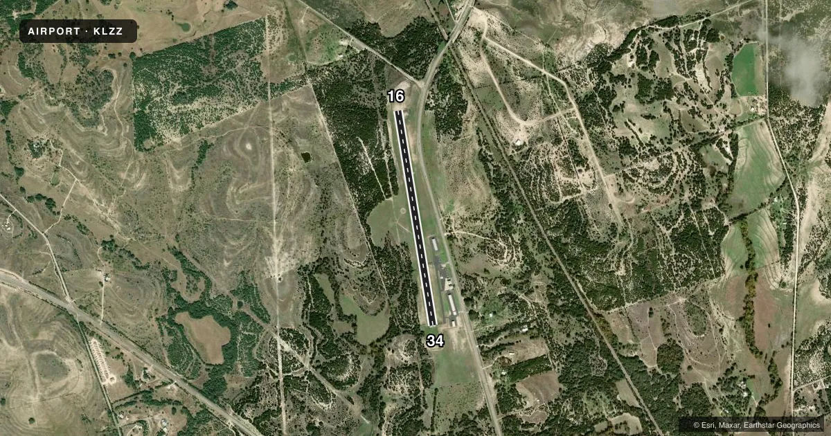
Airport sketch
Runways drawn to scale from FAA survey coordinates, rendered over satellite imagery. Not for navigation.
Approaches & charts
Services on the field
Fuel grades, oxygen, maintenance, ramp storage and lighting — as declared to the FAA by the airport operator.
Fuel & services
- Fuel
- 100LL
- Oxygen (bottled)
- Not available
- Oxygen (bulk)
- Not available
Ramp & ground
- Transient storage
- Tie-down
- Landing fee
- No fee published
- Customs
- Not available
- Lighting schedule
- SEE RMK
- Beacon schedule
- SS-SR
- Beacon
- White / Green (civil land)(WG)
- Wind indicator
- Lighted
- Segmented circle
- Yes
Fuel & FBOs
Cheapest 100LL and Jet A on the field and nearby. Always confirm with the FBO before taxi.
Airport notes
Surface conditions, obstructions, local procedures, lighting outages and other notes published with each FAA cycle.
General notes
- DEER ON & INVOF ARPT.
Lighting notes
- ACTVT PAPI RWYS 16 & 34; MIRL RWY 16/34 - CTAF.
Fuel notes
- 100LLFUEL 24 HR SELF SVC.
Approach & departure obstructions
- 166 FT GROUND, O FT DSTC, 124 FT R. 23 FT TREES, 0 FT DSTC, 208 R.
- 3412 FT BRUSH, 100-100 FT DSTC, 188L.
Other notes
- 2FOR ATTENDANT AFT HRS CALL AMGR.
VFR map & nearby airports
VFR sectional. Tap any ICAO chip to open that airport.
Key facts · KLZZ
Answer card- ICAO
- KLZZ
- Name
- LAMPASAS
- Location
- LAMPASAS, TEXAS
- Elevation
- 1,214.4 ft MSL
- Traffic pattern altitude
- 2,214.4 ft MSL (1,000 AGL)
- Control tower
- Non-towered (use CTAF)
- Total runways
- 1
- Longest runway
- 16/34 · 4,202 ft
- Published ILS approaches
- 0
- Published frequencies
- 4
- Magnetic variation
- 8°
- Current flight rules
- VFR
- Current wind
- 210° at 8 kt
- Favored runway now
- RWY 16
Lampasas Airport sits in Lampasas, Texas. Field elevation is 1,214.4 ft MSL. The airport has one runway. Runway 16/34 is 4,202 ft long and paved with asphalt. There is no control tower. The published pattern altitude is not listed, so use standard 1,000 ft AGL for light piston traffic unless the current Chart Supplement says otherwise.
No ILS approaches are published here. The field uses CTAF 122.8 for airport traffic. The published frequencies also include APCH/P DEP/P on 120.075 and 323.15. Lampasas Airport is served by Lampasas Airport on the field. It carries 100LL. Self-serve 100LL is available 24 hours. If you need an attendant after hours, call the airport manager.
A few operational notes matter here. Deer are reported on and near the airport. There are obstructions near both runway ends. Runway 16 has a 6-foot ground obstruction and 23-foot trees off the right side. Runway 34 has 12-foot brush off the left side. PAPI is available on runways 16 and 34. Medium intensity runway lights are controlled by CTAF. This is a non-towered field, so expect self-announced traffic and keep a close scan on final, especially at dusk when wildlife can move.