METAR & TAF KILE
Current METAR
Observed 12:56Z
KILE 271256Z AUTO 16005KT 10SM CLR 25/25 A3000 RMK AO2 SLP146 T02500250
- Wind
- 160° @ 5 kt
- Visibility
- 10 SM
- Temp / Dew
- 25°C / 25°C
- Altimeter
- 30.00 inHg
- Clouds
- CLR
- Density alt
- 2,152 ft
- Ceiling
- Unlimited
- Rules
- VFR
Airport info & contacts
Manager on record, flight service, ARTCC, attendance schedule and pattern altitude — published by the FAA and refreshed every 28 days.
Location
- From city
- 3 NM E
- VFR sectional
- SAN ANTONIO
- ARTCC
- ZFW · FORT WORTH
- NOTAM facility
- ILE (NOTAM-D)
Airport manager
- Name
- MIKE WILSON
- Phone
- 254-501-8728
- Address
- 8101 CLEAR CREEK RD., BOX C, KILLEEN TX 76549
Flight service · Hours
- FSS SJT
- SAN ANGELO1-800-WX-BRIEF
- Attendance
- 0800-1800
Frequencies
Tap any row to copy the frequency to your clipboard.
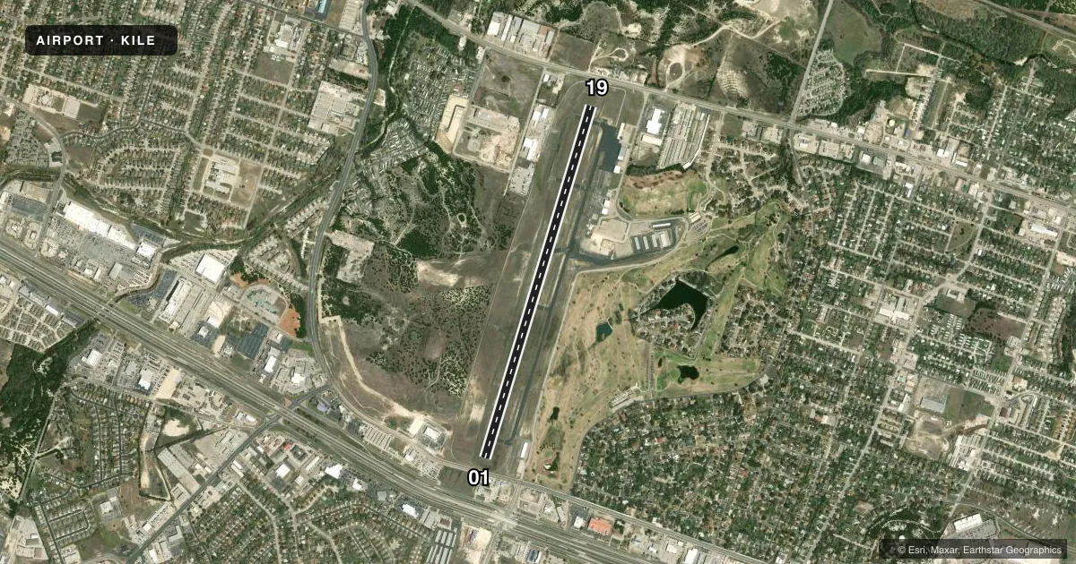
Runways & pattern
Full pagePattern entry · RWY 19
LEFT TRAFFICRunway end performance
| End | TORA | TODA | ASDA | LDA | VGSI | Approach lights | Obstruction |
|---|---|---|---|---|---|---|---|
| 01 | 5,495' | 5,495' | 5,495' | 4,651' | PAPI 4-box left(3°) | — | 20', road, 200' from thr, 500' R of cntrln, slope 0 |
| 19 | 5,495' | 5,495' | 5,295' | 5,295' | PAPI 4-box left(3°) | — | 24', pline, 200' from thr, 495' R of cntrln, slope 0 |
Declared distances in feet. TORA = takeoff run available, TODA = takeoff distance, ASDA = accelerate-stop, LDA = landing distance.
Airport sketch
Runways drawn to scale from FAA survey coordinates, rendered over satellite imagery. Not for navigation.
Approaches & charts
ILS · 1
Services on the field
Fuel grades, oxygen, maintenance, ramp storage and lighting — as declared to the FAA by the airport operator.
Fuel & services
- Fuel
- 100LLA
- Oxygen (bottled)
- Not available
- Oxygen (bulk)
- Not available
- Airframe repair
- Minor
- Power plant repair
- Minor
- Other services
- INSTR,PAJA,RNTL
Ramp & ground
- Transient storage
- Tie-down
- Landing fee
- No fee published
- Customs
- Not available
- Lighting schedule
- SEE RMK
- Beacon schedule
- SS-SR
- Beacon
- White / Green (civil land)(WG)
- Wind indicator
- Lighted
- Segmented circle
- Yes
Fuel & FBOs
Cheapest 100LL and Jet A on the field and nearby. Always confirm with the FBO before taxi.
Airport notes
Surface conditions, obstructions, local procedures, lighting outages and other notes published with each FAA cycle.
General notes
- FOR CD CTC FORT WORTH ARTCC AT 817-858-7584.
- ARPT PHYSICAL ADDRESS 1525 STONETREE RD. KILLEEN, TX.
Lighting notes
- MIRL RWY 01/19 SS-SR PRESET LOW INTST; TO INCR INTST & ACTVT TWY LIGHTS - CTAF.
Approach & departure obstructions
- 018 FT FENCE, 170 FT DSTC, 500 FT L/R. 20 FT RD, 185 FT DSTC, 500 FT L/R.
- 194 FT GROUND 183 FT LEFT AT THR.
- 01OBSTRUCTION CLEARANCE SLOPE 0:1 AT DSPLCD THR TO OVR 14 FT GROUND 500 FT L.
VFR map & nearby airports
VFR sectional. Tap any ICAO chip to open that airport.
Key facts · KILE
Answer card- ICAO
- KILE
- Name
- SKYLARK FLD
- Location
- KILLEEN, TEXAS
- Elevation
- 847.5 ft MSL
- Traffic pattern altitude
- 1,847.5 ft MSL (1,000 AGL)
- Control tower
- Non-towered (use CTAF)
- Total runways
- 1
- Longest runway
- 01/19 · 5,495 ft
- Published ILS approaches
- 1
- Published frequencies
- 5
- Magnetic variation
- 5°
- Current flight rules
- VFR
- Current wind
- 160° at 5 kt
- Favored runway now
- RWY 19
Skylark Fld sits in Killeen, Texas. The field elevation is 847.5 ft MSL. It has one runway. Runway 01/19 is 5,495 ft long and asphalt. There is no control tower. The airport has one ILS approach to runway 01. Pattern altitude is not published, so a light piston pilot should plan on the standard 1,000 ft AGL unless the current Chart Supplement says otherwise.
Flight Line Services is on the field. It carries AVGAS 100LL and Jet A. For a first-time arrival, pay attention to the published lighting setup. The medium intensity runway lights on 01/19 come up at low intensity from sunset to sunrise. Use CTAF if you need to increase intensity or activate taxiway lights. There are also published obstructions near both ends. Runway 19 has a 4-foot ground obstruction 183 feet left of the threshold. Runway 01 has an 8-foot fence and a 20-foot road near the approach area, both 500 feet left and right of centerline at the stated distances. The airport uses gray approach and departure frequencies, so verify the current Chart Supplement and brief the field before arrival. Clearance delivery is handled through Fort Worth ARTCC. This is a non-towered airport, so standard see-and-avoid discipline and a clean radio callout matter here.