METAR & TAF T74
Current METAR
Observed 07:35Z
KT74 280735Z AUTO 17006KT 10SM CLR 25/22 A2996 RMK AO2
- Wind
- 170° @ 6 kt
- Visibility
- 10 SM
- Temp / Dew
- 25°C / 22°C
- Altimeter
- 29.96 inHg
- Clouds
- CLR
- Density alt
- 1,894 ft
- Ceiling
- Unlimited
- Rules
- VFR
Airport info & contacts
Manager on record, flight service, ARTCC, attendance schedule and pattern altitude — published by the FAA and refreshed every 28 days.
Location
- From city
- 2 NM W
- VFR sectional
- SAN ANTONIO
- ARTCC
- ZHU · HOUSTON
- NOTAM facility
- SJT (NOTAM-D)
Airport manager
- Name
- STACEY BATCH
- Phone
- 512-352-5747
- Address
- 303 AIRPORT RD., #101, TAYLOR TX 76574
Flight service · Hours
- FSS SJT
- SAN ANGELO1-800-WX-BRIEF
- Attendance
- MON-FRI · 0800-1700
Frequencies
Tap any row to copy the frequency to your clipboard.
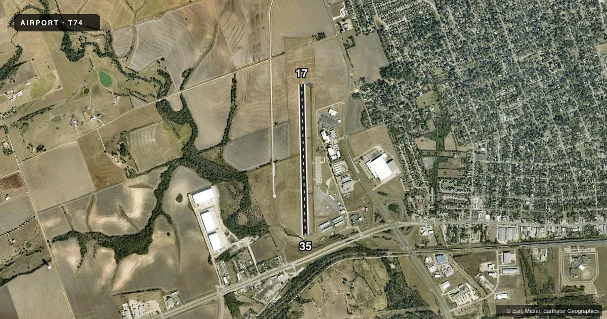
Runways & pattern
Full pagePattern entry · RWY 17
RIGHT TRAFFICRunway end performance
| End | TORA | TODA | ASDA | LDA | VGSI | Approach lights | Obstruction |
|---|---|---|---|---|---|---|---|
| 17 | — | — | — | — | PAPI 2-box left(3°) | — | 30', trees, 1030' from thr, 160' R of cntrln, slope 27 |
| 35 | — | — | — | — | PAPI 2-box left(3°) | — | 55', trees, 835' from thr, 215' R of cntrln, slope 11 |
Declared distances in feet. TORA = takeoff run available, TODA = takeoff distance, ASDA = accelerate-stop, LDA = landing distance.
Airport sketch
Runways drawn to scale from FAA survey coordinates, rendered over satellite imagery. Not for navigation.
Approaches & charts
Services on the field
Fuel grades, oxygen, maintenance, ramp storage and lighting — as declared to the FAA by the airport operator.
Fuel & services
- Fuel
- 100LLA+
- Oxygen (bottled)
- Not available
- Oxygen (bulk)
- Not available
- Airframe repair
- Major
- Power plant repair
- Major
- Other services
- AMB,INSTR
Ramp & ground
- Transient storage
- Tie-down
- Landing fee
- No fee published
- Customs
- Not available
- Lighting schedule
- SEE RMK
- Beacon schedule
- SS-SR
- Beacon
- White / Green (civil land)(WG)
- Wind indicator
- Lighted
- Segmented circle
- Yes
Fuel & FBOs
Cheapest 100LL and Jet A on the field and nearby. Always confirm with the FBO before taxi.
Airport notes
Surface conditions, obstructions, local procedures, lighting outages and other notes published with each FAA cycle.
General notes
- FOR CD CTC AUSTIN APCH AT 512-369-7865.
- 200 FT. AGL TWR, 1000 FT EAST OF RWY CENTERLINE, APX MID POINT OF RWY.
- INTSV HEL ACTVTY ON AND INVOF ARPT.
Lighting notes
- MIRLS RWY 17/35 PRESET LOW SS-SR. TO ACTVT & INCR INTST - CTAF.
Fuel notes
- A+100 LL & JET A SELF SERVE ONLY.
Approach & departure obstructions
- 35APCH RATIO 25:1 TO DSPLCD THR OVR 80 FT TREES 2000 FT DSTC.
Other notes
- HELI SVCS ALSO AVBL.
- THIS AIRPORT HAS BEEN SURVEYED BY THE NATIONAL GEODETIC SURVEY.
VFR map & nearby airports
VFR sectional. Tap any ICAO chip to open that airport.
Key facts · T74
Answer card- ICAO
- T74
- Name
- TAYLOR MUNI
- Location
- TAYLOR, TEXAS
- Elevation
- 600 ft MSL
- Traffic pattern altitude
- 1,600 ft MSL (1,000 AGL)
- Control tower
- Non-towered (use CTAF)
- Total runways
- 1
- Longest runway
- 17/35 · 4,000 ft
- Published ILS approaches
- 0
- Published frequencies
- 4
- Magnetic variation
- 5°
- Current flight rules
- VFR
- Current wind
- 170° at 6 kt
- Favored runway now
- RWY 17
Taylor Muni sits in Taylor, Texas. Field elevation is 600 ft MSL. The airport has one runway. Runway 17/35 is 4,000 ft of asphalt, which is the longest runway on the field. There is no control tower. Austin Approach handles clearance delivery and approach or departure services on 127.225 and 317.65 MHz.
No ILS approaches are published here. Pattern altitude is not published, so use the standard 1,000 ft AGL for light piston operations unless the current Chart Supplement says otherwise. The field has one on-field FBO, Taylor Municipal Airport. It carries 100LL and Jet A. Fuel is self-serve only.
A few local items matter here. Intensive helicopter activity is reported on and near the airport. There is also a 200 ft AGL tower about 1,000 ft east of the runway centerline near midfield. Runway 35 has an obstacle note for the approach path over 80 ft trees about 2,000 ft out. The runway lights are preset low from sunset to sunrise. Use CTAF 122.8 to activate and raise intensity. If you are planning a first stop here, keep the helicopter traffic, the tower and the runway 35 obstacle picture in mind.