METAR & TAF 3R9
3R9 does not publish a METAR.
Showing the nearest reporting station: KRYW (LAGO VISTA TX/RUSTY ALLEN) · 8.6 NM away. Conditions at 3R9 may differ.
METAR · KRYW
Observed 12:20Z
KRYW 271220Z AUTO 19004KT 10SM CLR 23/23 A3003 RMK AO2 T02320232
- Wind
- 190° @ 4 kt
- Visibility
- 10 SM
- Temp / Dew
- 23°C / 23°C
- Altimeter
- 30.03 inHg
- Clouds
- CLR
- Density alt
- 1,951 ft
- Ceiling
- Unlimited
- Rules
- VFR
Airport info & contacts
Manager on record, flight service, ARTCC, attendance schedule and pattern altitude — published by the FAA and refreshed every 28 days.
Location
- From city
- 2 NM SW
- VFR sectional
- SAN ANTONIO
- ARTCC
- ZHU · HOUSTON
- NOTAM facility
- SJT (NOTAM-D)
Airport manager
- Name
- AIRPARK BOARD
- Phone
- 512-261-4385
- Address
- 115 FLYING SCOT, LAKEWAY TX 78734
Flight service · Hours
- FSS SJT
- SAN ANGELO1-800-WX-BRIEF
- Attendance
- Unattended
Frequencies
Tap any row to copy the frequency to your clipboard.
Runways & pattern
Full pagePattern entry · RWY 16
LEFT TRAFFICRunway end performance
| End | TORA | TODA | ASDA | LDA | VGSI | Approach lights | Obstruction |
|---|---|---|---|---|---|---|---|
| 16 | — | — | — | — | — | — | 30', tree, 205' from thr, 0' R of cntrln, slope 0 |
| 34 | — | — | — | — | — | — | 34', trees, 201' from thr, 0' R of cntrln, slope 0 |
Declared distances in feet. TORA = takeoff run available, TODA = takeoff distance, ASDA = accelerate-stop, LDA = landing distance.
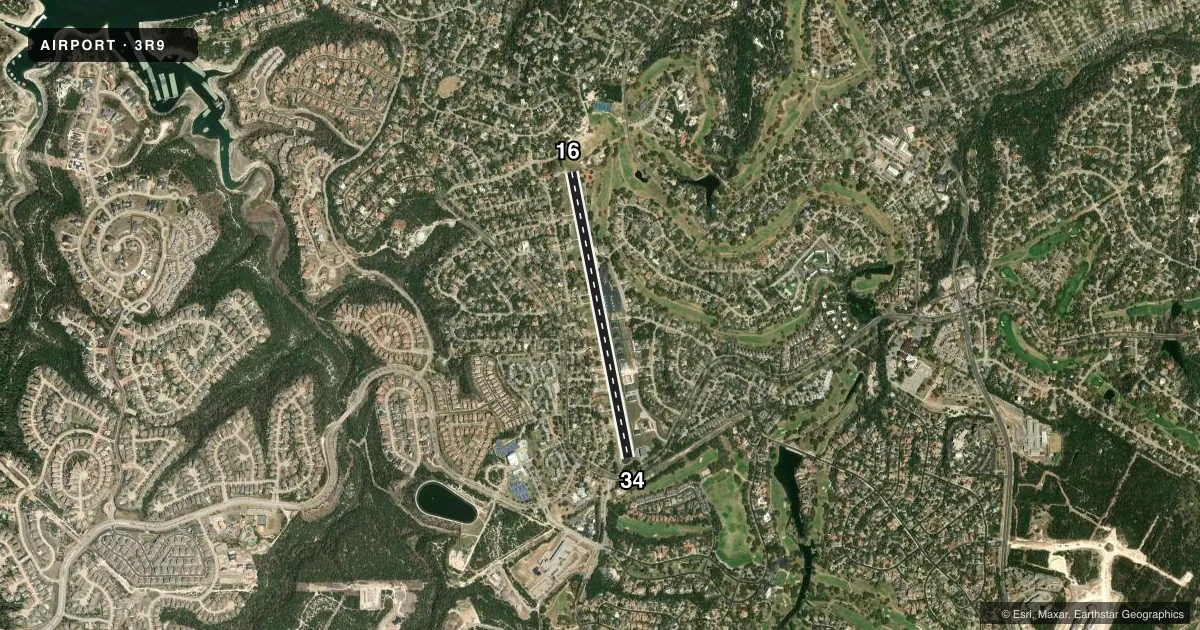
Airport sketch
Runways drawn to scale from FAA survey coordinates, rendered over satellite imagery. Not for navigation.
Approaches & charts
Services on the field
Fuel grades, oxygen, maintenance, ramp storage and lighting — as declared to the FAA by the airport operator.
Fuel & services
- Fuel
- 100LL
Ramp & ground
- Transient storage
- Tie-down
- Landing fee
- Yes
- Customs
- Not available
- Wind indicator
- Yes
- Segmented circle
- No
Fuel & FBOs
Cheapest 100LL and Jet A on the field and nearby. Always confirm with the FBO before taxi.
Airport notes
Surface conditions, obstructions, local procedures, lighting outages and other notes published with each FAA cycle.
General notes
- NO TGLS. NO LOW PASSES
- NO NGT OPNS PER CITY ORDINANCE.
- DEER ON & INVOF ARPT.
- NUMEROUS OBJECTS IN PRIM SFC.
- ARPT OPNS LTD TO ACFT WITH MAX GWT OF 12500 LBS OR LESS BY CITY ORDINANCE..
- ULTRALIGHT AND GLIDER OPNS PROHIBITED.
- MNTN RWY HDG TIL 1 MI & 400 FT AGL (1300 FT MSL) FOR NOISE ABATEMENT.
- BLDGS, TREES & PARKED ACFT NEAR RWY.
- 2-WAY RADIO COM RQRD ON CTAF.
- 3 FT NON-FRANGIBLE SIGNS 10 FT FM RWY EDGE AT DSPLCD THR, BOTH SIDES.
- FOR CD CTC AUSTIN APCH AT 512-369-7865.
- NO COML OPNS PER CITY ORDINANCE.
- RWY 34, 30 FT MKD PWR LINES ACRS APCH 155 FT DSTC.
- RWY 34, 30 FT MKD ELEC TMTN LINES CRS THRU APCH 200 FT DSTC.
- ARPT WX SR-SS CLICK MIKE 5X ON CTAF.
Fuel notes
- 100LLFUEL SELF-SVC.
Approach & departure obstructions
- 163 FT BANK 70 FT R OF CNTRLN 0-199 FT DSTC.
- 3434 FT TREES 75--200 FT DSTC ACRS APCH.
- 16APCH RATIO 0:1 TO DSPLCD THR OVR 40 FT TREE, 0 FT DSTC, 150 FT L.
- 34APCH SLOPE 0:1 TO DSPLCD THR OVR 27 FT BLDG 166 FT R & 42 FT TREES 208 FT L 0 FT DSTC,
Other notes
- LNDG FEE FOR TURBINES & JETS. OVNGT TIEDOWN FEE.
- 1ARPT CLSD SS-SR.
- 16/34RWY RISES FM S TO N 32 FT. ACFT NOT VISIBLE AT OPPOSITE END.
VFR map & nearby airports
VFR sectional. Tap any ICAO chip to open that airport.
Key facts · 3R9
Answer card- ICAO
- 3R9
- Name
- LAKEWAY AIRPARK
- Location
- LAKEWAY, TEXAS
- Elevation
- 909.4 ft MSL
- Traffic pattern altitude
- 1,909.4 ft MSL (1,000 AGL)
- Control tower
- Non-towered (use CTAF)
- Total runways
- 1
- Longest runway
- 16/34 · 3,930 ft
- Published ILS approaches
- 0
- Published frequencies
- 4
- Magnetic variation
- 4°
- Current flight rules
- VFR
- Current wind
- 190° at 4 kt
- Favored runway now
- RWY 16
Lakeway Airpark (3R9) sits in Lakeway, Texas at 909.4 ft MSL. It has one runway, 16/34, which is 3,930 ft long and asphalt. The field is non-towered. CTAF and UNICOM are both 123.0. Austin Approach is on 119.0 and 370.85. No ILS approaches are published here. The pattern altitude is not published, so use the standard 1,000 ft AGL for light piston traffic unless the current Chart Supplement says otherwise.
The on-field FBO is Lakeway Airpark. It carries 100LL. Fuel is self-service. If you need clearance delivery, Austin Approach is listed in the remarks with the phone number 512-369-7865. This is a local-use field with some limits that matter. Ultralights and gliders are prohibited. Aircraft over 12,500 lb max gross are not allowed by city ordinance. No commercial operations are permitted.
Runway and approach notes deserve a close look before you go. The runway rises from south to north by 32 ft. Aircraft are not visible at the opposite end. Runway 34 has marked power lines across the approach. There are also buildings, trees and parked aircraft near the runway. Check the current Chart Supplement and brief the runway environment carefully before arrival.